


Antioch Council discusses more redistricting maps, including fourth new map submitted Monday night
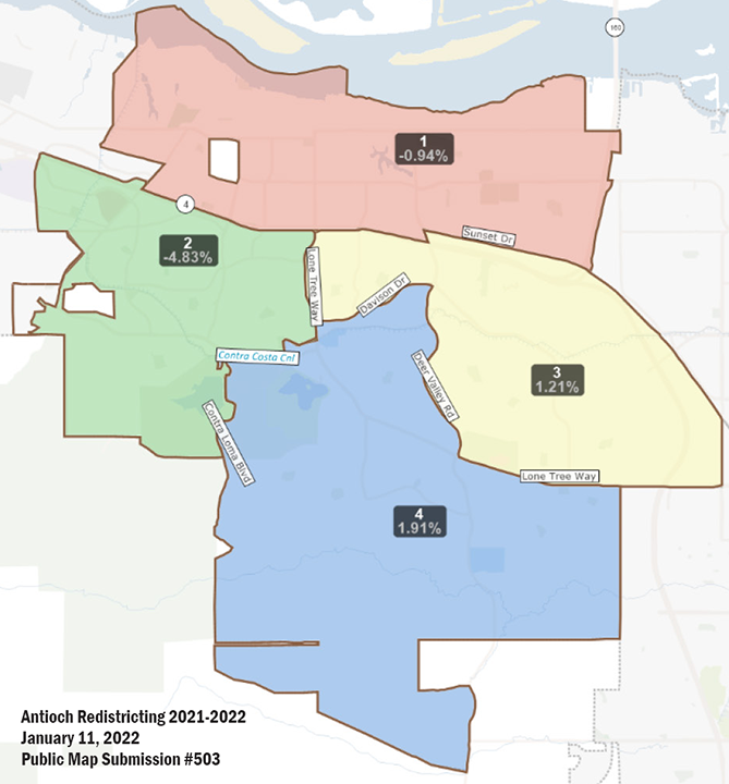
Antioch Redistricting Public Map #503 submitted Monday night is slightly incomplete on the west side of the proposed District 2. There were no User Comments provided. Source: www.antiochca.gov/fc/district-elections
Torres-Walker stands for Pledge of Allegiance; mayor welcomes Con Johnson as interim city manager, finally refers to him as “retired San Francisco Police Lieutenant”
By Allen Payton
During a public hearing at the beginning of Tuesday night’s meeting, the Antioch City Council reviewed new maps submitted by members of the public, as well as the eight maps previously reviewed, including three drawn by the consultant and five submitted by members of the public. In a surprise to some residents watching, District 1 Councilwoman Tamisha Torres-Walker stood for the Pledge of Allegiance, for the first time since the council returned to holding in-person meetings.
“Since the last meeting we have had four new submissions,” said Karin Mac Donald, owner and Senior Researcher of Q2 Data and Research. “Two of the public submissions don’t meet the Fair Maps Act” due to “contiguity”. She was referring to Maps 39 and 49 reviewed by the council at a previous meeting.
See all maps on the City’s Redistricting webpage under Draft Maps and Public Map Submissions.
“You have one more mapping meeting on Jan. 25th,” she added. “It would be good to whittle down the number of maps” for consideration.
A fourth new map, #503, was submitted last night. (See related article)
During public comments, resident Harry Thurston, one of only two residents to speak, again advocated for Map B, as he had at a previous meeting.
Resident Sharon Johnson asked, “what is the reason for redistricting when you just did it two years ago? My neighbors and I are wondering.”
“If you’re going to do it…” she continued, then said she also supported Map B “because it keeps current neighborhoods together.”
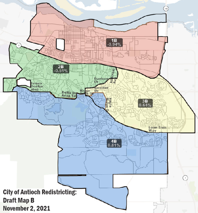
Drawn by consultant. Notes: Current Antioch City Council boundaries are shown in black on this map. Proposed boundaries are shown in brown and filled in with color. Draft Map B only modifies the boundary between District 3 and 4.
“This process is required every 10 years. What we did last time was not redistricting but districting due to a lawsuit…based on the Census,” Mayor Lamar Thorpe explained
The current districts are based on the 2010 Census. The new districts will be based on the 2020 Census which includes a population increase of 15,000 residents.
During that process in which the council adopted the current districts in May 2018, Thorpe asked Consultant Mac Donald about the current process. “Will we see drastic changes in where the lines will be?”
She responded by saying, “I think that depends on what you wanted to do. There is no law…that says you must start with the districts drawn in the last process.”
Thorpe then stated, “So, we can start with a completely new…or go with what we have and try to adjust the lines accordingly.” (See related articles here and here)
Council Reviews New Maps Submitted by the Public
“I would like to see the new maps that were submitted,” said District 3 Councilwoman Lori Ogorchock.
Jane Hood of Q2 then reviewed the four new submitted maps 91, 95, 99 and 503.
She pointed out that the new map, #503 was incomplete, as it is does not include a small portion on the west side of District 2. “It should be included with District 2,” Hood stated.
Ogorchock asked to see Map 91, again, which Hood put up on the screen.
About Map 95 Hood then said, “You’ll see this changes things, a bit.”
She then presented Map 99 and provided the population deviation percentages and described the boundaries.
“The last submission we have was received last night, which is #503,” Hood said, then reviewed the district boundaries and population percentages.
“This process continues until February so there’s time to submit maps,” Thorpe said.
“Do you want me to include all those maps in the staff report?” asked City Attorney Thomas L. Smith.
“Yes, please,” Thorpe replied. He then asked to review the City’s current districts map and the last two maps that the council considered in 2018.
“This map was created through public engagement and by the elected officials,” he said about a map that the council did not approve, known as Quadrants C. As reported previously, that map used major thoroughfares on the south side of Highway 4 as the dividing lines, such as Putnam Drive, Lone Tree Way and Deer Valley Road, as well as the Delta DeAnza Trail on the west side of the city.
Thorpe then spoke about the current districts map.
“This map wasn’t created by any public officials or by any member of the public,” he said. “This map was created by the consultant. No lines were changed…it was literally the exact map created by the consultant. I point this out because there’s been some implications that lines were moved to accommodate one individual council member. That’s a bold-faced lie.”
“That map passed on a 3-2 vote,” Thorpe continued. “There was some interest particularly by Latino residents up north that they haven’t had representation. This process was fair…of the highest regard. This map is fair.”
However, the consultant drew the map after extensive input from both members of the public and city council during several meetings and special workshops, during the 2018 process. Also, at that time, Thorpe said he supported having two council members represent the north side of the freeway stating, “North Antioch deserves two council people.” But in an Op-Ed by him published the day before, he advocated for one district north of the freeway. Plus, Thorpe was one of the three council members, along with Wilson and then-Councilman Tony Tiscareno to approve the current map with just one council member representing that area of the city.
In addition, during the 2018 process for creating the current map, then-Mayor Sean Wright said, “When you gerrymander you draw crazy lines to make sure you have the people in your district. When drawing the lines, I went down the major thoroughfares. I didn’t look at which family is where. I’m in favor of Quadrants C going forward and Working Draft 1.” (See related article)
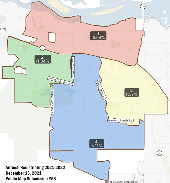
User Comments: “This leaves all current council members in their districts and makes more sense including the Silverado Drive area in District 2 instead of District 4, and makes Districts 2, 3 and 4 north-south oriented districts instead of east-west.”
Barbanica then asked to see Map 58 and for the Q2 staff to “go over the boundaries?”
Hood then described the district boundaries and population deviation percentages from average.
“It’s just an easy map to follow,” Barbanica said.
Thorpe Introduces Interim City Manager Johnson as Retired Police Lieutenant
The mayor then closed the public hearing and began the introductions of new city staff members.
“It is my duty to introduce our new city manager. Con Johnson is here, today. He took the helm, officially by himself, last week,” Thorpe said. “He’s a retired San Francisco Police Lieutenant. Con, we welcome you.”
“I would just like to thank the mayor and entire council members for this opportunity to work for this wonderful city,” Johnson said.
the attachments to this post:

Antioch-Redistricting-Draft-Map-B

Antioch-Redistricting-Public-Map-#58

Antioch-Redistricting-Public-Map-#503