Over $107 million for Contra Costa projects including $46.9 million on Hwy 4 from Hillcrest Avenue in Antioch to Byron Highway near Brentwood
By Edward Barrera, Division Chief, Caltrans Public Affairs
In August, the California Transportation Commission (CTC) approved $3 billion in allocations to enhance safety and mobility across the state highway system and expand multimodal travel, including bike lanes and pedestrian pathways. Guided by Governor Gavin Newsom’s Build More, Faster – For All infrastructure agenda, these improvements will make California communities safer, cleaner and increase access to active transportation options.
Of the $3 billion allocated, $663 million derives from Senate Bill (SB) 1, the Road Repair and Accountability Act of 2017 and approximately $2 billion from the federal Infrastructure Investment and Jobs Act of 2021 (IIJA). The funds will serve as a catalyst to increase the capacity of the state’s transportation system, rehabilitate aging roadways and improve travel times, while balancing community impacts and promoting environmental benefits.
The “…investments reflect California’s long-term commitment to safer roads, smarter traffic management and expanded transportation choices that get people where they need to go,” said Caltrans Director Dina El-Tawansy.
“The funds allocated…reflect the Commission’s commitment to investing taxpayer dollars strategically. These investments will improve the safety and reliability of the state’s transportation network and support a thriving economy by improving the movement of freight and reducing out-of-pocket expenses for all California,” said Darnell Grisby, Chair of the California Transportation Commission.
Projects in Contra Costa County approved by the Commission include:
$46,900,000 on SR-4 in and near Antioch and Brentwood, from Hillcrest Avenue to Byron Highway, to rehabilitate pavement and drainage systems, upgrade facilities to ADA standards, install Accessible Pedestrian Signals (APS), high-visibility crosswalks, bike loop detectors, and construct Class II bike lanes. This will extend pavement service life and improve ride quality.
$42,374,000 on I-680 in San Ramon and Danville, from Alcosta Boulevard to 0.1 mile north of Diablo Road, to rehabilitate pavement, upgrade guardrail, and upgrade facilities to ADA standards. This will extend pavement service life and improve ride quality.
$14,584,000 on SR-24 in Orinda, at the Caldecott Tunnel, to rehabilitate and upgrade the ventilation system in Bores 1, 2, and 3. This will ensure structural integrity and prolong tunnel service life.
$1,301,000 on SR-4 in Concord, 0.5 mile east of Port Chicago Highway, to reconstruct a failed slope embankment and repair a displaced down drain due to heavy rainfall in February and March 2025. Work includes installing Rock Slope Protection (RSP), and repairing the down drain, guardrail, and dike. This will enhance driver and pedestrian safety.
• $1,275,000 on SR-4 near Pittsburg, 0.3 mile west of Bailey Road, to reconstruct a slope embankment and repair a displaced down drain due to heavy rainfall in February and March 2025. Work includes installing Rock Slope Protection (RSP). This will improve roadway safety.
$999,000 on SR-24 in Lafayette, from 0.7 to 1.0 mile east of Acalanes Road, to rehabilitate pavement due to ponding and water seepage caused by heavy rainfall in February and March 2025, which led to cracking and settlement. This will extend pavement life and improve safety.
IIJA is a once-in-a-generation investment in our nation’s infrastructure to improve the sustainability and resiliency of our country’s energy, water, broadband and transportation systems. The total funding for California is nearly $54 billion. This includes investments to upgrade the state’s roads, bridges, rail, public transit, airports, ports, waterways and the electric vehicle charging network.
SB 1 has invested approximately $5 billion annually toward transportation projects since its adoption. It provides funding split between the state and local agencies. Road projects progress through construction phases more quickly, based on the availability of funds, including those partially funded by SB 1.
Visit build.ca.gov to learn more about transformative infrastructure projects happening in communities throughout the state.
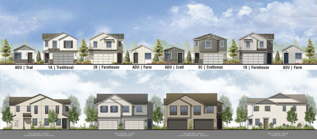
Renderings of the single-family homes and accessory dwelling units (top) and the duplexes (bottom) in the proposed Vineyard Crossing rental housing project. Source: BrightSky Residential
Will discuss $30 million lawsuit by desal plant general contractor
By Allen D. Payton
During their meeting on Tuesday, Oct. 14, 2025, the Antioch City Council will consider approving a 137-unit rental housing project in the northeast part of the city, within the City’s Priority Development Area north of the Antioch BART station. They will also consider spending an additional $245,000 on an Organizational Efficiency Implementation Consultant and splitting the $21 million L Street Pathway to Transit Project into two projects.
City Faces $30M+ Lawsuit by Desalination Plant General Contractor
Consultant for Organizational Efficiency Implementation Services
According to the City staff report, for Item 2.P., “It is recommended that the City Council adopt a resolution approving a Professional Services Agreement with K. Zelenka Consulting to provide organizational efficiency implementation services and other functions in an amount not to exceed $245,000…that will help the City Manager advance the City’s adopted efficiency review recommendations and ensure continuity in several key initiatives. The
consultant will concentrate on facilitating process improvements, coordinating efforts across departments, and supporting the City’s ongoing commitment to organizational effectiveness and customer-focused service delivery.”
In addition, the report reads, “K. Zelenka Consulting is in the process of completing the City’s comprehensive organizational efficiency audits, which have identified a series of actionable recommendations to improve operations, streamline processes, and enhance overall service delivery.
“The consultant will immediately continue the Operational Assessments with the Human Resources Department (in final draft phase) and will begin assessments for Antioch Police Department (APD) Dispatch Center, Community and Economic Development Department, and Parks and Recreation Services Department this month. The consultant will also identify new opportunities for process improvement, recommend strategies to enhance service delivery, and assist with community engagement and stakeholder communication related to organizational changes. As directed by the City Manager, the consultant may provide policy and program analysis and attend City Council or community meetings to present updates.
“Because K. Zelenka Consulting conducted the original organizational efficiency audits and possesses specialized knowledge of the City’s operations, her continued involvement is essential to maintain momentum and ensure consistency in implementation.
“Funding for this initiative will come from cost savings achieved during the vacancies of the Assistant City Manager and Executive Assistant positions within the City Manager’s office, while recruitment efforts to fill the open roles continue and commence.”
Vineyard Crossing Project Site map. Source: City of Antioch
Vineyard Crossing Rental Housing Project – Part of Almondridge, City’s PDA
Under Item 6, the Council will consider approving a 137-unit housing project by Walnut Creek-based BrightSky Residential on 14.6 acres located northwest of the intersection of Phillips Lane and Oakley Road within the City’s Priority Development Area near the BART Station. According to the City staff report, the proposed project would subdivide the project site into 71 individual lots containing 137 residential units total with 45 single-family residential lots and 40 accessory dwelling units (ADUs) on the western parcel. A condominium map could be recorded for the duplex lots 46-71 on the eastern parcel, for 26 duplex building lots creating 52 condominium lots.
In addition, the “proposed project designates 10% of base units (13 of the ADUs total) as affordable to low-income households to obtain a density bonus of 16 additional units (included in the 137) as well as waivers from certain development standards, in accordance with state density bonus law.” They would be deed-restricted and available for households earning 60 percent of the Area Median Income (AMI). The City’s proposed Inclusionary Housing Ordinance, which would require designating 15% of units in new developments as affordable, cannot apply as the Council has not yet adopted it.
The applicant has indicated that they intend to own and operate the entire project after construction as a rental housing community. However, the proposed Vesting Tentative Map is for condominium purposes for the duplex lots on the eastern parcel and would allow for the possible future sale of each residential duplex unit.
The project site is part of the Almondridge South Planned Development District that was entitled in 1991 but only partially developed since that time. Single-family residences were developed to the west of the project site, but both of the project parcels have remained undeveloped.
As part of the City’s 2003 General Plan, the western project parcel was designated Medium Low Density Residential with a density of up to 6 dwelling units/acre permitted and the eastern project parcel was designated Medium Density Residential with a density of up to 10 dwelling units/acre permitted.
The project applicant submitted a preliminary development plan and received feedback from the Antioch Planning Commission and City Council in December 2023 and January 2024 respectively.
The applicant submitted a Preliminary Application under SB 330 (The Housing Crisis Act of 2019). Through the Preliminary Application process put in place under SB 330, housing developments may only be subject to the ordinances and objective standards in effect at the time when a completed Preliminary Application is submitted. To qualify, projects had to be submitted prior to Jan. 1, 2025.
Rezoning Not Required, ADU’s Not Counted Toward Density per State Law
While the project does not conform to the adopted Planned Development zoning standards for the site such as lot size and setbacks, it is consistent with the density established in the General Plan, and therefore per state law, a rezoning is not required to develop the project. Additionally, per state law, accessory dwelling units are not counted as units for the purposes of determining the proposed density of a project.
As part of Plan Bay Area, each of the 101 cities in the nine-county Bay Area were required to set aside land for a Priority Development Area (PDA) near public transit planned for new homes, jobs and community amenities, including higher-density housing. In order for Antioch to obtain approval for a BART extension and station, the city council had to agree to 2,500 housing units in the City’s 400-acre PDA. It includes the land east of the BART station and north to E. 18th Street.
Amenities located on the western parcel of the site would include a recreation center with an outdoor pool area as well as a children’s play area. Amenities located on the eastern parcel would include an activity lawn area with park benches in the northern portion of the parcel.
Parking
The project provides a total of 408 parking spots. This includes 194 spots within 2-car garages for each single-family home and duplex unit, 130 spots within the single-family home and ADU driveways, and 84 spots on streets. Projects receiving a density bonus are entitled to reduced parking standards, with a maximum parking requirement of 1.5 parking spaces for a 3-bedroom unit (all units proposed for the development, with the exception of the ADU’s are 3-bedroom). The 45 single family homes and 52 duplex units would therefore require 146 parking spots.
The project parking therefore exceeds what is required for a density bonus project, and in fact also exceeds standard municipal code requirements for parking (single family detached – 2 spots per unit in a garage plus 1 guest spot – 135 total – single family attached – 2 spots per unit plus 1 per 5 units for guest parking – 114 spots total).
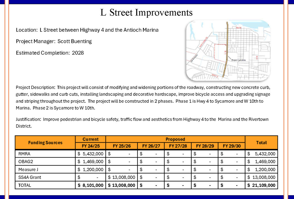
L Street Improvements Plan. Source: City of Antioch 5-Year CIP 2025-30
Split $21 Million L Street Pathway to Transit Improvement Project into Two
Under Item 8 the council will consider splitting the planned $21 million L Street improvement project into two projects to reserve funding.
According to the City staff report for the item, the L Street Pathway to Transit (“Project”) will improve accessibility for all modes of transportation and beautify the L Street corridor between Highway 4 and the Antioch Marina.
“The first phase of work on the Project will consist of modifying portions of the roadway, constructing new concrete curb, gutter, sidewalks and curb cuts, installing landscaping and decorative hardscape, improve bicycle access and upgrading signage, and striping throughout the Project from Highway 4 to Sycamore Drive, and from West Tenth Street to the Marina.
“The second phase of work will consist of widening the roadway to four lanes between West 10th Street to West 18th Street, installation of new sidewalks on the western side of the roadway, ADA-compliant upgrades, signal improvements at the intersection of W. 10th and W. 18th Streets, enhanced bus facilities, and the addition of bike lanes. (P. W. 234-16).
“In order to keep the funding sources separately, staff recommends separating this work into two projects. The first phase will be funded by Measure J funds in the amount of 1,191,465 and the One Bay Area Grant (OBAG2) in the amount of $1,469,000. The second phase will be funded by the state’s Road Maintenance and Rehabilitation Account (RMRA) in the amount of $5,244,167, and a U.S. Department of Transportation’s Safe Streets and Roads for All (SS4A) Grant in the amount of $13,008,000, which has already been budgeted for in the 5 Year Capital Improvement Program 2025-2030.”
The meetings will be held in the Council Chambers at City Hall, 200 H Street, in Antioch’s historic, downtown Rivertown. They can also be viewed via livestream on the City’s website and the City’s YouTube Channel, on Comcast Cable Channel 24 or AT&T U-verse Channel 99.
Leighann Kingsbury. Photos courtesy of her sister.
By Allen D. Payton
According to Antioch Police Lt. Joe Njoroge, a pedestrian was struck by a train on Tuesday evening, Oct. 7, 2025, in the area of 6th and A Streets. BNSF, the railroad company, are the primary investigators, he added.
According to Contra Costa County Deputy Coroner Aaron Carson, the victim was identified as Leighann Kingsbury, 34 years old, from Massachusetts.
Antioch homeless advocate Nichole Gardner spoke with Kingsbury’s sister who said she was from Worcester and moved here 14 years ago and confirmed Leighann was unhoused at the time of her death.
Please be advised that Wilbur Avenue On-ramp to southbound SR-160 and E. 18th Street Off-Ramp on southbound SR-160 will remain closed throughout the closure. This extended closure is required to safely and efficiently complete construction activities in the area.
DETOUR DIRECTIONS?
Detour signs will be posted, and Changeable Message Signs (CMS) will alert drivers of the closure. Drivers should expect delays, allow extra travel time and exercise caution while navigating the detours. All work is weather permitted. Caltrans appreciates the public’s patience and cooperation while crews perform this critical work.
Existing transportation funding strained by rising construction costs, population growth, potential decrease in state gas tax revenue
“115 of 1,374 bridges are rated poor/structurally deficient, with significant deterioration” – TRIP Report
By Carolyn Bonifas Kelly, Director of Communication & Research, TRIP
San Francisco, CA – While additional state and federal transportation funding is allowing California to repair and improve roads and bridges, a new report documents looming challenges including population growth, rising congestion, construction cost inflation and declining fuel-tax revenue. The report by The Road Information Program, TRIP, a national transportation research nonprofit based in Washington, DC, examines California’s road and bridge conditions, congestion and reliability, highway safety, economic development, vehicle travel trends, and the impact of recent state and federal transportation funding increases.
The TRIP report, “Keeping California Mobile: Providing a Modern, Sustainable Transportation System in the Golden State,” finds that throughout the state, traffic fatalities have increased significantly in the last decade despite recent downward trends, 50 percent of major roads are in poor or mediocre condition, five percent of locally and state-maintained bridges (20 feet or more in length) are rated poor/structurally deficient, and traffic congestion costs the state’s drivers $55 billion annually in lost time and wasted fuel. In addition to statewide data, the TRIP report includes regional pavement and bridge conditions, congestion data, highway safety data, and cost breakdowns for the Los Angeles, Riverside-San Bernardino, Sacramento, San Diego, San Francisco-Oakland and San Jose urban areas.
The TRIP report finds that 73 percent of major locally and state-maintained roads in the San Francisco-Oakland urban area are in poor or mediocre condition, costing the average motorist an additional $1,106 each year in extra vehicle operating costs, including accelerated vehicle depreciation, additional repair costs, and increased fuel consumption and tire wear. Statewide, 28 percent of California’s major roads are in poor condition and 22 percent are in mediocre condition. TRIP estimates that the state’s drivers lose $24.2 billion annually in extra vehicle operating costs as a result of driving on deteriorated roads.
In the San Francisco-Oakland area, eight percent of bridges (115 of 1,374 bridges) are rated poor/structurally deficient, with significant deterioration to the bridge deck, supports or other major components. This includes locally and state-maintained bridges that are 20 feet or longer. Statewide, five percent of California’s bridges are rated poor/structurally deficient. Most bridges are designed to last 50 years before major overhaul or replacement. In California, 54 percent of the state’s bridges were built in 1969 or earlier.
According to the TRIP report, traffic congestion in the San Francisco-Oakland area causes 111 annual hours of delay for the average motorist and costs the average driver $3,406 annually in lost time and wasted fuel. On average, San Francisco-Oakland drivers waste 38 gallons of fuel annually due to congestion. Statewide, drivers lose $55 billion annually because of lost time and wasted fuel due to traffic congestion. Due to the Covid-19 pandemic, vehicle travel in California dropped by as much as 41 percent in April 2020 (as compared to vehicle travel during the same month the previous year).By 2025, vehicle miles of travel in California had rebounded to five percent below 2019’s pre-pandemic levels. Congestion reduces job accessibility significantly. In California’s six largest metros, the number of jobs accessible within a 40-minute drive during peak hours were reduced by 44 percent in 2023 as a result of traffic congestion.
Source: TRIP
Traffic crashes in California claimed the lives of 24,508 people from 2019 to 2024. The state’s 2024 traffic fatality rate of 1.19 fatalities for every 100 million miles traveled was slightly lower than the national average of 1.2. The number of traffic fatalities and the fatality rate per 100 million vehicle miles of travel in California spiked dramatically in 2020 and 2021 before falling each year from 2022 to 2024. But, despite recent progress, from 2014 to 2024 the number of traffic fatalities in California increased 24 percent and the state’s traffic fatality rate increased 29 percent. From 2019 to 2023, 30 percent of those killed in California crashes involving motorized vehicles were pedestrians or bicyclists. In the San Francisco-Oakland area, 36 percent of traffic fatalities between 2019 and 2023 (306 of 934) were pedestrians or bicyclists.
“California’s future depends on transportation infrastructure that can withstand the challenges of a changing climate and a growing population,” said Senator Dave Cortese, chair of the California Senate Transportation Committee. “These investments don’t just move people and goods—they cut emissions, strengthen communities, create jobs, and spur economic growth. The TRIP report makes clear that smart infrastructure investments are among the most powerful tools we have to support California’s workforce and drive long-term economic prosperity.”
Improvements to California’s roads, highways and bridges are funded by local, state and federal governments. In April 2017, the California legislature enacted SB 1 — the Road Repair and Accountability Act. SB 1 increased state revenues for transportation by increasing the state’s gasoline and diesel taxes, implementing a transportation investment fee on vehicles and initiating an annual fee on zero emission vehicles. SB 1 is estimated to increase state revenues for California’s transportation system by an average of $5.2 billion annually through to 2027. In addition to state transportation funding, the Infrastructure Investment and Jobs Act (IIJA), signed into law on November 2021, provides $25.3 billion in federal funds to the state for highway and bridge investments in California over five years, representing a 29 percent increase in annual federal funding for roads and bridges in the state over the previous federal surface transportation program. The IIJA is set to expire on September 30, 2026.
“California’s transportation system is the backbone of our daily lives, connecting millions of people to work, school, and opportunity,” said Assemblymember Lori Wilson, chair of the California State Assembly Transportation Committee. “The TRIP report provides the proof points behind what we already know: our infrastructure needs are urgent and growing. As we transition to cleaner vehicles and more sustainable mobility, we must secure fair and reliable funding solutions to ensure tomorrow’s infrastructure serves Californians better than today’s.”
The ability of revenue from California’s motor fuel tax – a critical source of state transportation funds – to keep pace with the state’s future transportation needs is likely to erode as a result of increasing vehicle fuel efficiency, the increasing use of electric vehicles and inflation in highway construction costs. The Federal Highway Administration’s national highway construction cost index, which measures labor and materials cost, increased by 48 percent from the beginning of 2022 through the fourth quarter of 2024.
The California Legislative Analyst’s Office (LAO) found that steps taken by California to reduce greenhouse gas emissions, including programs and policies that are targeted at increasing the adoption of zero-emission vehicles (ZEVs), increasing the use of lower-carbon fuels, and reducing the number of vehicle miles traveled will reduce state transportation revenues by $4.4 billion over the next decade. This reduction in state transportation spending which is projected to result in poorer road conditions. However, the recent federal rollbacks to California strict emissions requirements will impact these programs and policies.
“Our deteriorating transportation system costs Californians lives, time, and money,” said California Transportation Commissioner Joseph Cruz. “Every investment in improving and maintaining our roads, bridges, and transit networks is an investment in people. These projects don’t just build infrastructure – they create good jobs, support local economies, and ensure California’s workforce is at the center of the solution.”
Source: TRIP
The efficiency and condition of California’s transportation system, particularly its highways, is critical to the health of the state’s economy. In 2023 California’s freight system moved 1.4 billion tons of freight, valued at $2.8 trillion. From 2022 to 2050, freight moved annually in California by trucks is expected to increase 65 percent by weight and 100 percent by value (inflation-adjusted dollars). The design, construction and maintenance of transportation infrastructure in California supports approximately 420,000 full-time jobs across all sectors of the state economy. Approximately 7.1 million full-time jobs in California in key industries like tourism, retail sales, agriculture and manufacturing are dependent on the quality, safety and reliability of the state’s transportation infrastructure network.
“California’s transportation dollars are already being stretched thin by increased inflation in construction costs and declining fuel tax revenue,” said Dave Kearby, TRIP’s executive director. “Without additional transportation investment, needed projects that would make the state’s roads safer, smoother and more efficient will not move forward.”
Every trip matters! No matter if you’re driving to work, catching BART, biking to school, or strolling your neighborhood, we have a plan to make traveling around our county easier, safer, and smarter.
The Contra Costa Transportation Authority (CCTA) is updating your Countywide Transportation Plan (CTP), and we’re asking residents to weigh in on the next 25 years of investments that will keep our communities moving smoothly and sustainably.
What’s on the Table?
In 2024, CCTA surveyed residents to find out what transportation solutions were most needed in their Contra Costa community — and thousands of you responded! Public engagement in early 2025 identified strategies for improving transportation
Based on your feedback, CCTA has created a series of Transformative Visions — bold project and program ideas that are visionary and will bring safer streets, more reliable transit, cleaner air, and more access to good transportation options for every corner of Contra Costa County. Your feedback will help us refine these ideas and decide which deserve top priority.
These visions are:
Create People-First Transportation Spaces: Redesign streets to put people first, making everyday travel safer, easier, and more comfortable.
Provide a Complete, Reliable Transit Network: Expand fast and reliable bus, shuttle, rail, and ferry services that come more often and connect you to key places.
Provide Reliable Freeway Travel: Keep freeways moving smoothly by reducing backups from crashes, better using existing travel lanes, and fixing bottlenecks.
Build Vibrant Communities: Revitalize and create places where people can live, gather, and connect to natural and community destinations.
Learn more about these Transformative Visions. Complete this brief survey to tell us which best fits YOUR vision for Contra Costa County. Your feedback will help us refine and update these Transformative Visions to show what the Plan’s focus should be for transportation investments in the next 25 years.
Why Take the Survey?
Influence real projects. Your answers guide where billions in transportation funds are spent.
It’s quick. The survey is mobile-friendly and takes just a few minutes.
Perks! Complete it and you can enter a drawing to win one of five $100 virtual Visa gift cards—the sooner you participate, the more chances you’ll have to win.
Survey window. The questionnaire is open through September 30, so don’t wait.
We greatly appreciate your feedback. Individuals who complete this survey may enter a drawing to win one of five $100 virtual VISA gift cards. Winners’ names will be drawn throughout the survey period, so the earlier you take the survey, the more chances you will have to win! The survey is open through September 30.
“The New TDT Network” brings community-driven changes to nearly all of the agency’s bus routes
By Leeann Loroño,Manager of Customer Service and Marketing, Tri Delta Transit
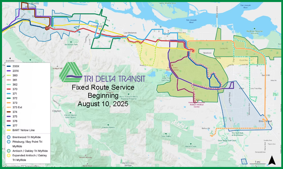
After canvassing East County for input from riders and residents over the last year, Tri Delta Transit (also known as East Contra Costa Transit Authority) is poised to launch a significant realignment of its transit system, offering service that is faster, more direct and more frequent beginning Aug. 10.
Dubbed “The New TDT Network,” this realignment brings sweeping changes to nearly every Tri Delta Transit route, informed by a blend of public feedback and data analysis. Bus routes across the system have been made faster and more direct, with better connectivity between buses and BART.
A brief video highlighting the major changes of the new network – and how they were determined – is available at revitalizetridelta.com.
Busier areas will see more frequent and consistent service, with improved weekend service across the board. The updated system introduces a brand-new route running every 15 minutes, along with four additional routes operating every 30 minutes, making morning commutes smoother for bus riders.
“We wanted to be sure these changes served local riders – particularly those who rely on transit for their morning commutes,” said Contra Costa County Supervisor Diane Burgis, who chairs Tri Delta Transit’s Board of Directors. “These updated routes – including Tri Delta Transit’s first route to run every 15 minutes – will not only greatly improve commutes for those who already ride but open up new possibilities for those whose schedules didn’t align with the previous system.”
Source: Tri Delta Transit
Integration with Tri MyRide has also been expanded to better serve the Brentwood, Antioch and Oakley areas, while maintaining existing coverage in the Pittsburg and Bay Point area.
“From the beginning of the New TDT Network initiative, our goal has been to ensure that the new network is able to better meet the needs of the communities we serve,” said Rashidi Barnes, CEO of Tri Delta Transit. “This new network is a direct result of that goal and aligns with everything we’ve heard from the public over the last year. Our riders can look forward to consistent bus service with lower wait times that offer faster, more direct routes to where they need to be.”
For details on specific route changes and other information about The New TDT Network, visit revitalizetridelta.com.
About Tri Delta Transit
Tri Delta Transit provides over 2,000,000 trips each year to a population of over 315,000 residents in the 225 square miles of eastern Contra Costa County. For additional information about the Tri Delta Transit, please visit www.trideltatransit.com.
A legislatively mandated and voter-approved gas tax increase of 1.6 cents and updated fuel standards that could, according to experts, translate to 5 to 8 centsnot 65 cents per gallon
What you need to know: There are many disingenuous claims swirling about California gas prices “set to soar” – the truth is that gas prices won’t come anywhere close to increasing by 65 cents, as many would have you believe.
By Office of the California Governor
SACRAMENTO – California gas prices are 20 cents lower than one month ago and 17 cents lower than one year ago – despite a swirl of misinformation drawing attention to current prices.
According to a 2024 report, thanks to major improvements in fuel efficiency, California drivers rank 45th in the nation for gasoline consumption and 21st in spending on gasoline per capita. Trump’s tariffs and policies impacting the price of crude oil stand to swing gas prices far more than any state policy.
Driven by misinformation pushed by Republican lawmakers and the oil industry, there remains a lot of speculation about California gas prices. Here are the facts.
CLAIM: California gas prices will go up by 65 cents or higher on July 1.
FALSE. There are two separate changes to fuel prices expected on or around July 1 – a legislatively mandated and voter-approved gas tax increase of 1.6 cents and updated fuel standards that could, according to experts, translate to 5 to 8 cents.
Gas tax: California’s gasoline tax will increase by 1.6 cents per gallon, starting July 1, as required by law. This annual inflation increase was enacted by the Legislature in 2017 to help pay for road repairs – and overwhelmingly approved by voters in 2018 when they rejected a repeal attempt.
Fuel standard: Additionally, changes to the state’s Low Carbon Fuel Standard (LCFS) – which is not a tax – have been requested to go into effect on July 1. Experts at UC Davis estimate this program, first established by Republican Governor Arnold Schwarzenegger, could add between 5 and 8 cents per gallon – well below one extreme projection that showed 65 cents. In the long term, LCFS is estimated to reduce fuel costs for Californians per mile by 42% – translating to savings of over $20 billion in gasoline costs every year by 2045. Studies also show that LCFS credit prices have no correlation with gasoline prices.
CLAIM: Gas prices could top $8 a gallon by next year.
FALSE. That number – widely reported in the media – comes from an unscientific analysis whose author has close ties with the oil industry and has been on the payroll of the Kingdom of Saudi Arabia. The author fails to provide evidence to support his main claim and only relies on vague references to models with no details on what those models are based on. Other experts, such as these Stanford economists, say gas price increases based on recent refinery announcements are likely to be negligible.
CalTax Says Gas Tax Will Increase to 61.2 Cents per Gallon
The tax rate on diesel fuel – a matter of great interest for many businesses, especially those in the trucking and agricultural industries – will increase from 45.4 cents per gallon to 46.6 cents per gallon, likely leading to higher costs for consumers for many goods and services.
The tax increases are in addition to any other increases that may be imposed as a result of fuel standards developed by the California Air Resources Board (CARB). Increases resulting from CARB actions also would take effect July 1.
The gas tax rate has more than doubled during the past 10 years. The largest year-to-year increase occurred in 2017 as a result of SB 1 (Chapter 5, Statutes of 2017), which increased gas tax by 12 cents per gallon and increased the diesel tax by 20 cents per gallon (both effective November 1, 2017) and required that the rates be adjusted annually based on the California Consumer Price Index.
Although Californians often mention vehicle-related taxes as a topic of major concern – and cited an increase in the vehicle license tax as a major factor in their decision to recall Governor Gray Davis in 2003 – the CDTFA did not issue a news release or use its social media channels to alert the media or general public to the increase. Instead, the increase was posted on the agency’s website as a special notice to retailers of gas and diesel fuels.