Archive for the ‘Recreation’ Category

3 parks in California ranked in Top-10 Best National Parks for Hiking

Saturday, June 1st, 2024

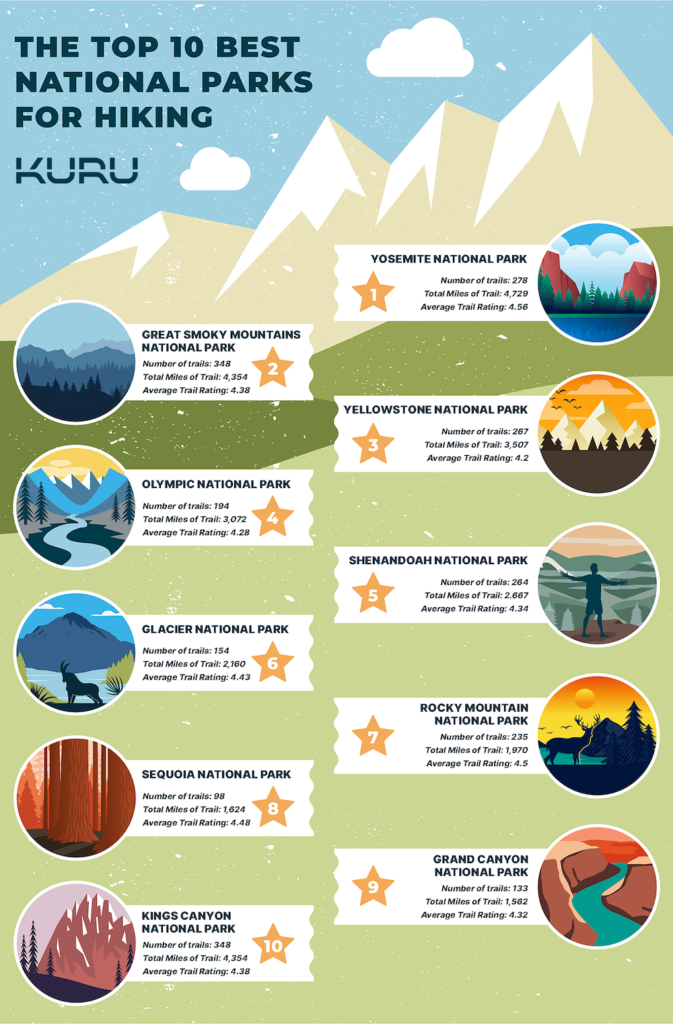
Yosemite ranked #1, Sequoia #8 & Kings Canyon #10

On this National Trails Day see how all 63 national parks rank for hiking, most trails, most miles of trails & most visitors

By KURU Footwear Media Team

National parks are a national treasure—and Americans know it.

In fact, the National Park Service saw 325.5 million recreation visits in 2023 (that’s up more than 13 million visitors from the previous year!), and almost half of Americans (48%) say visiting the national parks is on their bucket list.

National parks help preserve and protect many of our nation’s stunning natural landscapes, so we can behold the beauty for years to come—often through one of thousands of breathtaking hikes.

With summer coming up and kicking off (unofficially) with Memorial Day weekend in May, we wanted to dig into data and find the top 10 best national parks for hiking to help Americans discover their next adventure.

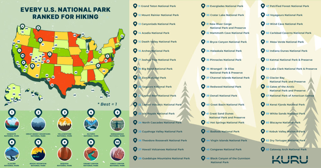
Which National Parks are the Best for Hiking?

With so many show-stopping trails in the U.S. National Park System (over 44,000 combined miles of them!), we knew we needed to narrow it down.

To find our top national parks for hiking, we looked at several metrics: high number of trails, miles of trails, and a high average trail rating score. We also found the crowd density in each park by comparing the average number of daily visitors with the acreage of the park.

Here’s what we found!

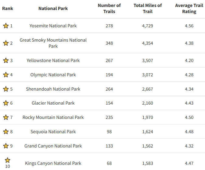
Yosemite National Park takes our #1 slot with 278 trails, 4,729 miles of trail, and a 4.56 average trail rating. Located in the Sierra Nevada mountains of California, Yosemite is known for its iconic and striking Half Dome, tall waterfalls, and giant Sequoia trees.

Source: KURU Footwear

Let’s dig into a more detailed breakdown of parks ranked by number of trails, miles of trails, and annual visitors!
Every National Park Ranked for Hiking

Here are our rankings of all 63 national parks based on our metrics. Total mileage was rounded up to the nearest whole mile for the purposes of the table.

As a note, our rankings are based on specific metrics, but everyone’s priorities are unique! So, when it comes time for your national parks trip, feel free to reference this list while ultimately choosing the parks that most inspire you. We feel every national park is worth a visit!

Source: KURU Footwear

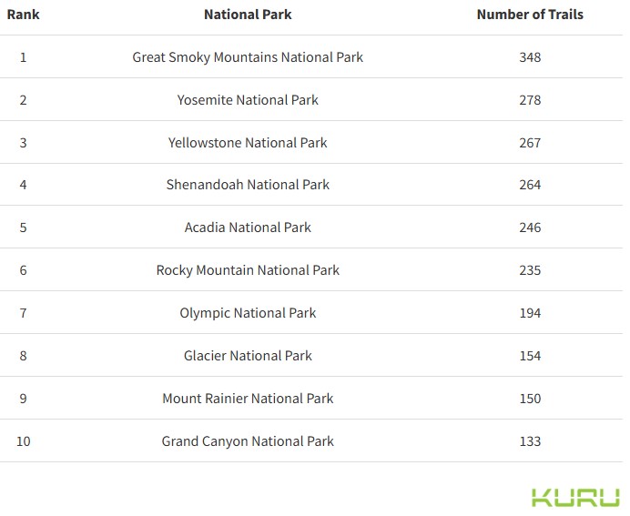
Which National Parks Have the Most Trails?

The national park system offers a tremendous total of 4,155 trails. Even if you ambitiously decided to hike one each day with no days off, you’d need a whopping 11 years to do it!

But if you’re looking for hiking options for the whole family, choosing a park with a high number of trails is a smart way to ensure there’s something for everyone.

Source: KURU Footwear

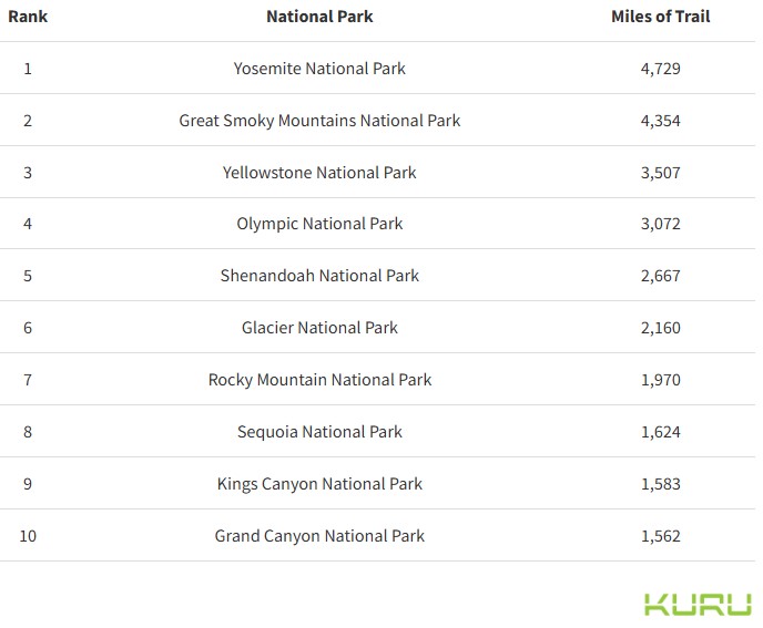
Which National Parks Have the Most Miles of Trails?

When mileage matters most (or you’re just hoping to get your steps in!) choosing a park with plenty of miles of trails might be your best bet.

With an impressive 44,370 combined miles of trails within national parks, you certainly won’t be short of options. The longest trail in the National Park System is the North Country Trail—spanning 4,600 miles across eight states!

Source: KURU Footwear

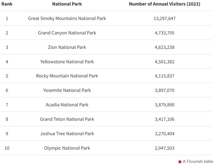
Which National Parks Get the Most Visitors?

Great Smoky Mountains National Park topped our list as the most visited, receiving almost 3 times as many visitors as the second most-visited national park, Grand Canyon National Park!

As you plan your next national park adventure, you may or may not want a lot of people around for the party. Here are the parks with the most visitors in 2023.

Source: KURU Footwear

Final Thoughts & Tips for Hiking in the National Parks

Now that you’ve discovered more info about some of our nation’s top national parks, here are a few tips on how to prepare for a visit to your bucket-list destination!

  • Do your research. Before you leave, we recommend planning your trip in advance by researching weather, trails you want to prioritize, trail difficulty, length, bathroom stops, and finding any needed lodging.
  • Wear supportive footwear. Bring a pair or two of comfortable, supportive shoes with plenty of traction, as you could walk many miles per day as you explore.
  • Stay hydrated. Bring plenty of water to get you through long days. It’s smart for each person to wear a hydration pack along with additional bottles of water if needed.
  • Use sun protection. When in the sun, apply sunscreen every two hours, wear a hat and sunglasses, and wear moisture-wicking clothing with as much coverage as possible.
  • Bring a first-aid kit. On the trail, you might not have immediate access to medical care, so bring a kit with you that includes the basics (think disinfectant, bandaids, ace bandage, etc.) until you can get more help.

Whichever park you decide on, we hope you have a spectacular visit!

About the National Parks

Since 1916, the National Park Service has been entrusted with the care of our national parks. With the help of volunteers and partners, we safeguard these special places and share their stories with more than 318 million visitors every year. But our work doesn’t stop there.

We are proud that tribes, local governments, nonprofit organizations, businesses, and individual citizens ask for our help in revitalizing their communities, preserving local history, celebrating local heritage, and creating close-to-home opportunities for kids and families to get outside, be active, and have fun.

Taking care of the national parks and helping Americans take care of their communities is a job we love, and we need—and welcome—your help and support. Learn more on the National Park Service website.

Methodology and Sources

Methodology

We used data from the National Park Service and AllTrails to find the number of available trails in all 63 National Parks in the United States, then ranked each on a scale of best to worst based on number of trails, miles of trails, average trail rating, and park crowd levels.

We used Alltrails to find all of the available trails in each of the 63 National Parks, and analyzed them based on the following metrics:
Number of Trails (Total)
Total Distance of Trails (in Miles)
Average Trail Rating (1-5 Scale)
Number of Annual Visitors (2023)
Acreage of the National Park (Public Areas Only)
These variables were weighted as follows to achieve our final scores and subsequent rankings:
(40%) Number of Trails
(35%) Miles of Trail
(20%) Average Trail Rating
(5%) Park Crowd Levels
Each metric was normalized on a 0-1 scale with 1 corresponding to the measurement that would most positively affect the final score. These adjusted measurements were then added together with the weights mentioned above to get a score of 100.
Sources
1. AllTrails.com
2. National Park Service – Reports (General)
3. National Park Service – 2023 Recreation Visitors
4. National Park Service – Trails & Hiking
5. National Park Service – Acreage by Park
About KURU
At KURU, we’re on a mission to help you Heel Better™ with footwear technology designed to relieve foot pain, so you can live a life you love. Since launching our innovative technology in 2008, we’ve received more than 32,000 five-star reviews from thousands of customers who tell us their KURU shoes helped them with conditions (such as plantar fasciitis) and got them back to doing what they love.

American Discovery Trail Society sponsors ADT Challenge for this year’s National Trails Day, June 1

Thursday, May 30th, 2024

By Ders Anderson, Open Lands

The American Discovery Trail Society announces its second annual trail challenge! In honor of the American Hiking Society’s National Trails Day, June 1, the Challenge is an invite to anyone and everyone living near the 6800-mile American Discovery Trail. (See related article)

The goal of the Challenge is meant to be a personal one, a trail challenge that hikers, bicyclists, runners, baby stroller pushers, skaters, and wheel-chair users set for themselves. It could be…adding miles to their personal best so far. It could be…enlisting friends who don’t often exercise. It could be… the first time for a family hike. It could be… a distance hike-bike-or run relay with a group of friends. It could be…a first, really-long-distance hike, whether it’s 20, 50 or 500 miles.

American Discovery Trail map. Source: ADT Society

Participants are asked to register at  https://discoverytrail.org/american-discovery-trail-home/trailchallenge/  where ADT trail access and route info, local trail agency contacts, and general trail use guidance will be available

Think…Outdoors…Healthy Exercise…Fresh Air…Inspiration…America’s Beautiful Landscapes…Participating in a national event with thousands of National Trail Day partners.

California Trails

If you participate in the ADT Challenge, the American Discovery Trail Society will report back to the American Hiking Society on the level of participation in the ADT Challenge. National Trails Day (NTD) is an annual event that has been sponsored by the American Hiking Society (AHS) for the past 31 years. Your experience will be added to this years’ overall NTD national participation. In 2022, over 125,000 people participated in National Trails Day.

About ADT

The American Discovery Trail (ADT) is the nation’s first coast-to-coast, non-motorized recreation trail. The ADT was conceived in 1989 and initially led by the American Hiking Society. In 1996 the ADT Society (ADTS) was created and has been the prime advocate for the completing a continuous trail across the United States. The ADTS considers it the east-west “backbone” of our country’s national trails system, connecting to the Appalachian Trail, Pacific Crest Trail, East Coast Greenway Trail and 50 other national scenic, historic and recreational trails. In the Midwest, two options are possible: either thru Iowa and Nebraska, and northern Illinois and Indiana, or through Missouri and Kansas and southern Illinois and Indiana.

Allen D. Payton contributed to this report.

Love Life’s annual LifeRide fundraiser in Antioch June 15

Saturday, May 25th, 2024

Sponsors needed

By Sophia Martin, Regional Director, Love Life NorCal Antioch

Please support us in our annual fundraiser, LifeRide. We will be riding bikes across the nation to raise awareness and funds to unite and mobilize the Church to end abortion and the orphan crisis.

What is LifeRide?

In 2023, Pastor Jay Stewart at the age of 60, rode his bicycle over 3,100 miles across America to bring awareness to the ministry of Love Life and to raise over a million dollars. Pastor Jay has been a partnering pastor with Love Life from the beginning and his church is also a House of Refuge church. (See video1 and video2)

Locally, our goal is to raise $10,000. If you would like to give $25, $50 or $100 to help us meet our goal and learn more, please visit: https://join.liferideusa.org/team/580862.

“Rescue those who are being taken away to death; hold back those who are stumbling to the slaughter.” – Proverbs 24:11

For more information about Love Life visit: https://lovelife.org. To sign up for a 1-Hour Journey visit: https://lovelife.org/1-hour-journey. Get your Love Life apparel and coffee here: https://shop.welovelife.org/?ref=antioch.

Parks district issues tick season advisory

Wednesday, May 22nd, 2024
Source: EBRPD

It’s better to be ticked off than ticked on

By East Bay Regional Park District

Whether you’re hiking in East Bay Regional Parks, venturing into nearby open spaces, or simply relaxing in your own yard, it’s important to be wary of ticks, which are often present in tall grass, brush, and wooded areas. Visitors are encouraged to keep tick safety precautions in mind when visiting East Bay Regional Parks throughout the spring, summer, and fall seasons.

Ticks carry germs that can cause a number of diseases, including Lyme disease. Lyme disease is an infectious disease transmitted by the bite of a tick. It may be treated and cured with early diagnosis, but if not properly treated, it may persist in the body for years. Visit www.bayarealyme.org for more information.

What Does a Tick Look Like? In California, the western black-legged tick is the major carrier of Lyme disease. The adult female is reddish brown with black legs, about 1/8 inch long. Males are smaller and entirely brownish black. Both are teardrop shaped. Most ticks can’t fly or jump. They wait on the tips of grasses and in shrubs along well-used paths. With their front legs outstretched, they easily climb aboard unsuspecting hosts when they brush by.

Tick Safety Tips

  1. Wear long pants, long sleeves, and closed-toe shoes.
  2. Tuck shirt into pants, and pants into socks.
  3. Use insect repellent on shoes, socks, and pants.
  4. Check yourself, your children, and your pets for ticks thoroughly and frequently.
  5. Keep children and pets nearby. For maximum safety, consider keeping your dog on a leash.
  6. Stay on trails. Avoid brush and grassy areas.

What To Do If Bitten By A Tick

  1. Pull the tick gently from the skin using a tissue or tweezers (not with bare hands).
  2. Scrape to remove any mouthparts left behind. An item such as a credit card can be used.
  3. Wash hands and the tick bite with soap and water; apply antiseptic to the bite. Prompt removal of ticks may prevent disease transmission.
  4. See a physician immediately if you think you have found a tick attached to your skin and you have any of the above symptoms. Early symptoms may include a spreading rash accompanied by fever, aches, and/or fatigue.

Download the Park District’s Living with Ticks brochure. Additional information is available at ebparks.org/safety/wildlife-encounters.

The East Bay Regional Park District is the largest regional park system in the nation, comprising 73 parks, 55 miles of shoreline, and over 1,330 miles of trails for hiking, biking, horseback riding, and environmental education. The Park District receives an estimated 30 million visits annually throughout Alameda and Contra Costa counties in the San Francisco Bay Area.

Free Teen Skate Night in Antioch Thursday, May 9

Monday, May 6th, 2024

Get ready to roll! You’re invited to Teen Skate Night at Paradise Skate in Antioch. This event is open to ages 12-18 and includes free skate rentals, food, and admission. Rest assured, adult supervision will be provided throughout the event. We look forward to seeing you there!

Please be advised: For all youth under the age of 18, a parent/guardian signature is required for sign-out at the conclusion of the event. Please come to the front entrance to sign out. Should you have any inquiries or concerns, please contact youth@antiochca.gov

For more information visit paradiseskate.com or www.antiochca.gov/pscr/youth-services/council-of-teens.

Automatic gate to be installed at Antioch Marina Boat Launch parking lot

Wednesday, April 3rd, 2024

Closure Friday, April 5; hours of access to boat launch will not change

From City of Antioch

Attention Residents

IMPORTANT NOTICE: Boat Launch Parking Lot Closure

Date: Friday, April 5 Time: 7:00 AM – 3:00 PM

Please be advised that the Antioch Marina boat launch parking lot at the foot of L Street will be CLOSED this Friday!

Our contractors will be hard at work installing a brand-new automatic gate. As part of this process, they will be cutting into the driveway leading into the parking lot.

For safety reasons, access to the parking lot will be restricted during this time. We apologize for any inconvenience this may cause and appreciate your cooperation.

Plan ahead and make alternate arrangements if you were planning to use the boat launch during these hours.

Thank you for your understanding and patience as we work to improve our facilities for everyone’s enjoyment!

UPDATE: According to Antioch Recreation Department Director and Acting Assistant City Manager Brad Helfenberger, “With the installation of the new gate, the level of access to the boat launch parking lot will not change. Currently, our landscaping contractor manually opens and closes the gate each day. With the new automatic gate, we will be able to program the opening and closing times depending on the season. The current access hours are 6am-9pm.”

Allen D. Payton contributed to this report.

Antioch Rotary Club to hold 8th Annual Bunny Hop 5K Saturday, March 30

Tuesday, March 26th, 2024

For more information about the Antioch Rotary Club visit www.facebook.com/antiochrotaryclub.

Opening of Mokelumne Trail Bicycle and Pedestrian Overcrossing in Brentwood celebrated

Wednesday, March 20th, 2024
Pedestrians and a bicyclist cross the recently completed Highway 4 Mokelumne Trail Overcrossing in Brentwood on March 20, 2024. Photos: CCTA

Transportation, city officials were joined by dozens of cyclists and pedestrians to cut the ribbon, make the inaugural walk over new $13 million bridge 

BRENTWOOD, CA – Almost two years to the day of the groundbreaking, as of today, Wednesday, March 20, 2024, the Mokelumne Trail Bicycle and Pedestrian Overcrossing in Brentwood is officially open to the public.

Officials of the Contra Costa Transportation Authority (CCTA), City of Brentwood, State Route 4 Bypass Authority, Contra Costa County and Metropolitan Transportation Commission cut the ribbon to ceremonially open the recently completed bridge across Highway 4 between Lone Tree Way and Sand Creek Road.

Transportation and city officials, and former Brentwood Mayor Bob Taylor (in yellow) who first proposed the project, cut the ribbon for the opening of the Mokelumne Trail Overcrossing on March 30, 2024. Photo: CCTA

They were joined by dozens of eagerly awaiting bicyclists and pedestrians to make the inaugural bike and walk on the overcrossing. The bridge now provides safe access to bicyclists and pedestrians for commuting and recreational travel and as part of the Mokelumne Coast to Crest Trail which includes the Delta de Anza Regional Trail that runs through Antioch and Oakley.

The 850-foot bridge structure includes a wider trail-width of 16 feet to accommodate bicyclists and pedestrians using the trail or accessing a potential future transit station. The bridge also meets Americans with Disabilities Act (ADA) standards to support use by all community members. The overcrossing will also provide access to the future Brentwood Transit Center and BART Station.

“The opening of the Mokelumne Pedestrian Overcrossing marks a significant milestone for alternative and innovative transportation in Contra Costa County,” said CCTA Board Chair Newell Arnerich. “The bridge was designed for the future in mind: access to future development in Brentwood as well as creating a wider pathway to someday accommodate many forms of environmentally friendly travel, including autonomous shuttle vehicles.”

Bicyclists, including advocate Bruce Ohlson (grey beard) and CCTA Executive Director Tim Haile (in blue vest) prepare to ride across the Mokelumne Trail Overcrossing following the ribbon cutting on Wed., March 20, 2024. Photo: CCTA

The overcrossing also provides a connection to the planned Innovation Center at Brentwood, a 200+ acre parcel that city officials have zoned for employer and development partners to create a workplace community.  

“The City of Brentwood is proud to have partnered with CCTA on this important project, which brings greater connectivity for bicyclists and pedestrians in Eastern Contra Costa County,” said Mayor Joel Bryant. “The project complements the City’s emphasis on innovation, safety and being financially wise – no city funds were used to construct the overcrossing.”

The cost to design and build the bridge was approximately $13 million, with funding provided through Measure J taxpayer dollars, the State Route 4 Bypass Authority and Bay Area Toll Authority (BATA) bridge toll funds. 

Mokelumne Trail Overcrossing partner agencies.

“Closing the gap between the Mokelumne Trail by constructing a bridge to span Highway 4 was a priority project for CCTA as the overcrossing allows safe access to cyclists and pedestrians for commuting and recreational travel,” said CCTA Executive Director Tim Haile who spoke while wearing a helmet as he said  rode his bike to the event and rides his bike to work every day. “This project represents CCTA’s commitment to improving mobility and furthering safe and accessible transportation for all.” 

Learn more about the overcrossing by clicking here: Mokelumne Trail Bicycle/Pedestrian Overcrossing.

About the Contra Costa Transportation Authority: 

The Contra Costa Transportation Authority (CCTA) is a public agency formed by Contra Costa voters in 1988 to manage the county’s transportation sales tax program and oversee countywide transportation planning efforts. With a staff of 23 people managing a multi-billion-dollar suite of projects and programs, CCTA is responsible for planning, funding, and delivering critical transportation infrastructure projects and programs that connect our communities, foster a strong economy, increase sustainability, and safely and efficiently get people where they need to go. CCTA also serves as the county’s designated Congestion Management Agency, responsible for putting programs in place to keep traffic levels manageable. More information about CCTA is available at ccta.net.

Allen D. Payton contributed to this report.