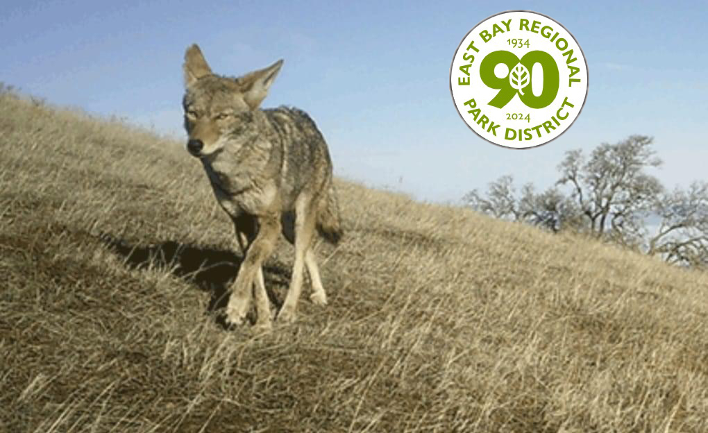
As visitation to East Bay Regional Parks increases in warmer months, encounters with coyotes become more common. Coyotes are native to California and are found in various wildland habitats, as well as in rural and urban areas. They hold cultural and ecological importance throughout the state.
Coyote parents are active and protective of den sites from spring through fall, when new pups are born. It is a normal reaction for them to run away when spotted, although some have become used to human presence and will continue their activities while being watched. Visitors are encouraged to keep coyote safety precautions in mind when visiting Regional Parks throughout the year.
Coyote Safety Tips
Avoid hiking alone so you have help in case of emergency.
Keep children and pets nearby; keep your dog(s) on a leash.
Be aware of your surroundings as you walk, jog, or ride.
Stay on trails.
Never attempt to feed a coyote.
What To Do If You See a Coyote
Keep an eye on the coyote and observe from afar. Do not approach or engage with the coyote; walk away calmly and leave the area quickly. Do not run. If you have small children, keep them close by. If you have a small dog, keep them on a leash.
What To Do If Approached By A Coyote
Rarely, a coyote may approach you. If a coyote moves within 50 feet and does not go away on its own, encourage the coyote to move away to help it retain a natural fear of humans.
Be as big and loud as possible; shout in a deep, loud, and aggressive voice.
Wave your arms.
Keep dogs and children nearby.
Maintain eye contact, which can make coyotes uncomfortable and timid.
If the coyote continues to approach, do not run or turn your back on the coyote but continue to exaggerate the above gestures while backing away slowly.
Help protect all wildlife and their environment. Never feed, approach, or pet wild animals. For emergencies, contact 911 or the East Bay Regional Park District Public Safety line (510) 881-1833, 24 hours a day.
The East Bay Regional Park District is the largest regional park system in the nation, comprising 73 parks, 55 miles of shoreline, and over 1,330 miles of trails for hiking, biking, horseback riding, and environmental education. The Park District receives an estimated 30 million visits annually throughout Alameda and Contra Costa counties in the San Francisco Bay Area.
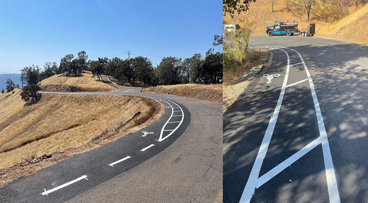
Examples of newly installed bicycle turnouts at Mount Diablo State Park. Source: CA State Parks
By Clint Elsholz, Superintendent, Diablo Range District, CA State Parks
California State Parks, in partnership with the California State Parks Foundation, Mount Diablo Cyclists, and community donors, began construction on June 3, on 22 new bike turnouts at Mount Diablo State Park (SP). Once completed, these new turnouts will bring the total turnouts in the park to 67. Turnouts allow bicyclists, who move at slower speeds as they pedal uphill, to pull out of the main traffic lane into their own lane so that vehicles can pass safely.
“State Parks is very excited to implement these critical safety measures with our partners,” said Diablo Range District Superintendent Clint Elsholz. “Each turnout can provide our visitors with a safer and more enjoyable park experience.”
Project construction is expected to be completed by fall 2024. Here is what the public can expect during construction:
The three park roads receiving new turnouts (South Gate Road, Summit Road and North Gate Road) will be closed on weekdays, from 8 a.m. on Monday through 2 p.m. on Friday. The park will be fully open on the weekends during the project.
This work will be done in three phases, with the first phase beginning on June 3, on South Gate Road. Southgate Road will remain closed on weekdays for approximately five weeks until the project moves to Summit Road and then to North Gate Road.
Vehicles, bicyclists, equestrians, and hikers will be prohibited on the closed roads until the project is completed.
Camping will only be allowed on Friday and Saturday nights in campgrounds along closed roads.
All trails and fire roads will remain open throughout the project.
At the completion of this important road safety project, California State Parks and its partners will plan a celebration event to commemorate these safety improvements and recognize contributors to the project. Road closures updates and celebration event information will be provided at parks.ca.gov/MountDiablo.
Public safety at this popular destination remains a priority for State Parks. Over the past few years, several safety enhancements have been implemented, such as double yellow line striping on the roads, designating passing areas, repaving portions of the road, improving safety signage, and installing designated bike turnouts. To date, State Parks has installed 45 bike turnouts at Mount Diablo SP. Along South Gate Road, there are a total of 17 turnouts, 16 along North Gate Road, and 12 along Summit Road.
Visitors to Mount Diablo SP are encouraged to share the road. Here are some tips to keep your visit safe and enjoyable:
All Users
Check the weather, bring water, and wear layers.
Don’t forget sunscreen.
Obey park rules.
Park in designated areas.
Tell someone where you are going and when you plan on returning.
Help us keep animals wild by viewing them from a safe distance. Do not touch or feed them.
Drivers and Cyclists
Observe posted speed limits.
Stay in your lane on blind curves and do not cut corners.
Do not pass on double yellow lines and until you have a clear view of oncoming traffic, and it is safe to do so.
Wearing headphones that cover both ears is illegal. Wear only one headphone if you must.
Hikers
Use the “buddy system” – hike with a friend or family member.
Drink and carry plenty of water (a minimum of 1 quart every 2 hours).
Wear sturdy, comfortable, closed-toe shoes to help prevent injury.
Stay within designated trails. Do not walk off-trail or enter closed areas.
Equestrian Riders
Check the weather, bring water, and know where to find water. Bring snacks for you and your horse.
Know your level. Trails can be beginner, intermediate, and advanced.
Groom and condition your horse before leaving the barn.
Bring your own first aid kit and cell phone. Attach it to your body, not your horse or saddle.
Ride with a buddy.
Wear a helmet and protective clothing.
Carry a compass and a trail map.
Although the rule is that cyclists and hikers yield to horses, be prepared for that not to happen.
If your horse kicks, tie something red in its tail.
Make sure to leave enough distance between horses. You should be able to see the hooves of the horse in front of you.
California State Parks provide for the health, inspiration and education of the people of California by helping to preserve the state’s extraordinary biological diversity, protecting its most valued natural and cultural resources, and creating opportunities for high quality outdoor recreation.
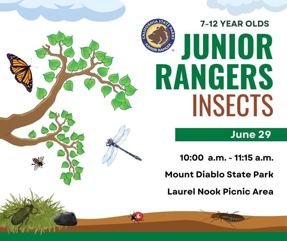
Do you think our six-legged neighbors are creepy or cool? Join us to take a closer look at the world of insects. Learn about fierce predators, plant munchers, and nectar sippers and how they get a meal. We’ll search for insects, play a game, and design our own imaginary insects.
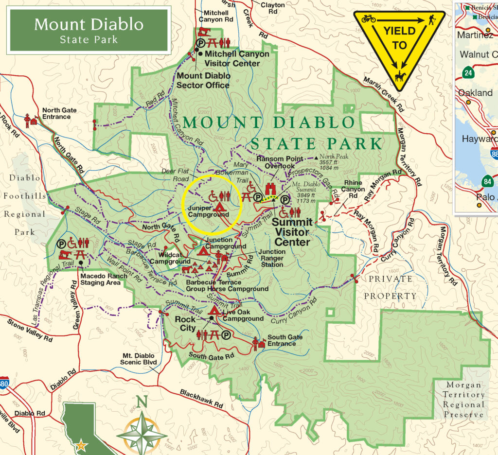
Meet at Laurel Nook Picnic Area. June 29, 10:00 a.m. – 11:15 a.m. Park at the Diablo Overlook parking area next to Juniper Campground (see yellow circle on map below). There is a $10 per vehicle entry fee.
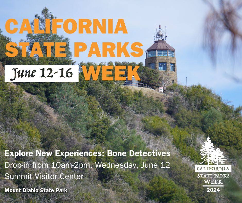
Become a “bone detective” this Wednesday, June 12. Start off California State Parks Week at Mount Diablo with a trip to the Summit to explore something new.
Examine bones and skull replicas and use your powers of observation to solve the mystery of what animals they belong to and to discover the interesting secrets they reveal about how each survives.
An early view of Rose Hill Cemetery in the foreground of Black Diamond Mines Regional Preserve in 1972 before restoration efforts by park staff next to the public county road that went through the park. Source: EBRPD
Second collection of Martin J. Cooney Series available online
By Flora Csontos Acting Public Information Specialist,East Bay Regional Park District
The East Bay Regional Park District is proud to unveil the Martin J. Cooney “Park Landscapes” online photo collection. This digital photo exhibit debuts a rare gathering of beautiful, nostalgic images that capture parkland and open space views of the East Bay from 1965 to 1981. At that time, the Park District was embarking on a period of considerable growth, tripling the number of Regional Parks to over 30. The Martin J. Cooney “Park Landscapes” collection has been carefully researched and curated by Park District Archives staff and volunteers, who have dedicated many hours to the preservation of the District’s history. As part of the ongoing 90th Anniversary celebrations planned throughout 2024, the photo collection is now available on the Park District’s Celebrating 90 Years webpage (www.ebparks.org/celebrating-90-years).
The release of the Martin J. Cooney “Park Landscapes” collection spans over 14 years of Park District photojournalism from the 1960s to the early 1980s. It memorializes landscapes, historic structures, and new parklands that later became part of the Regional Parks.
The Park District has grown to be the largest regional park district of its kind in the nation, with 73 regional parks available for hiking, biking, swimming, horseback riding, boating, fishing, picnicking, camping, and nature discovery. Wherever you live in the East Bay, there is a beautiful regional park close to you. The Park District manages over 126,000 acres of parklands, 55 miles of shoreline, and more than 1,330 miles of trails in Alameda and Contra Costa counties.
In 2016, Martin’s family donated over 15,000 negatives to the Park District, which were taken in the 1960s to1980s when the Martin J. Cooney commercial studio provided professional photography services to the Park District. While Martin took some of the photos, most were taken by Nancy McKay, who became an apprentice of Martin’s in 1968 while working in the Park District’s Public Affairs Department and serving as its primary photographer for over 37 years. Additional Cooney photo collections were donated in association with the Oakland Tribune archives and are housed at the Oakland Museum of California.
The four Cooney photo collections being released this year in commemoration of the Park District’s 90th Anniversary include People in Parks (already available on the Celebrating 90 Years webpage), Park Landscapes, Park District Workers, and Special Events.
Join us in celebrating the East Bay Regional Park District’s 90th Anniversary with online photo exhibits and stories available through the Park District’s website. Explore the interactive photo collections, story maps, timelines, and online exhibits. Additional events and programs celebrating the Park District’s 90th Anniversary also include monthly naturalist-led “Explore Your Parks” adventure programs, among others. For more information about 90th Anniversary activities, visit www.ebparks.org/celebrating-90-years.
Additional Curated Collections and Stories on Celebrating 90 Years Webpage
MARTIN J. COONEY PHOTO COLLECTION – “PEOPLE IN PARKS”
Visit the first in a series of exhibits featuring the Martin J. Cooney photography collection (1964-1980) from the Park District Archives.
FOUNDING OF THE EAST BAY REGIONAL PARK DISTRICT
Parks for the People (and By the People) – Explore the historic timeline of the formation of the East Bay Regional Park District (1864-1936).
TILDEN REGIONAL PARK HISTORY
Did you know that many of the Regional Parks have historic features and unique stories? Explore your parks in a new interactive Story Map series, debuting with Tilden Regional Park.
Father’s Day themed activities Sunday, June 16; Juneteenth Free Park Day Wednesday, June 19
By Flora Csontos, Acting Public Information Specialist, Public Affairs, East Bay Regional Park District
Thank you to the estimated 6,000 attendees who celebrated the East Bay Regional Park District’s 90th Anniversary at ParkFest at Lake Chabot Regional Park on May 11 and enjoyed a fun event filled with music, performances, food, and more. What a great time celebrating nearly a century of preserving open space and providing East Bay residents with access to nature close to home. Join us for more fun events throughout the year celebrating 90 years of East Bay Regional Parks, including “Explore Your Parks” programs, festivals, story sessions, picnics, and much more. For more information, visit www.ebparks.org/celebrating-90-years.
––––––––––
The largest creek restoration project in the Park District’s history was recently completed at Sibley Volcanic Regional Preserve, which removed several culverts and opened up 3,000 feet of creek to a more natural run. It is also the largest creek daylighting project in the entire Bay Area.
The Alder and Leatherwood Creek Restoration and Public Access Project, previously referred to as the McCosker Project, provides natural habitat for special status or protected species, including the California red-legged frog, California foothill yellow-legged frog, Alameda whipsnake, San Francisco dusky-footed wood rat, golden eagle, Cooper’s hawk, loggerhead shrike, northern harrier, and white-tailed kite. Water quality and streamflow were also improved by the project, providing new habitat for rainbow trout.
The project was made possible through $4 million in funding secured by Assemblymember Rebecca Bauer-Kahan in the 2019 state budget. Additional funding came from the Park District’s voter-approved Measure WW and other state and federal grants from the U.S. Environmental Protection Agency, Wildlife Conservation Board, Coastal Conservancy, California State Parks, and voter-approved Propositions 1, 84, and 50 allocated by the California Natural Resources Agency.
Park District launches pilot program to streamline entry at Del Valle Regional Park. East Bay RegionalPark District began a new pilot project on Memorial Day weekend to expedite park entry at Del Valle on weekends and holidays. Entry to Del Valle Regional Park on busy weekends and holidays can be very challenging as visitors line up at the entry kiosk to pay for park admission and parking. With the pilot project, visitors will pay a single $10 flat fee to enter the park rather than individual fees based on park use. The $10 flat fee covers park parking, trailers, and dogs. Fishing and quagga inspection fees can be purchased at the marina area. The $10 flat fee does not apply to Regional Parks Foundation members, who receive free park entry/parking at all Regional Parks as part of membership benefits. To help expedite entry, a limited number of passes will also be available for pre-purchase online at www.ebparks.org/parks/del-valle/pre-purchase-parking. As vehicles approach the kiosk, there will be a separate line for pre-paid parking, staff, members, and residents. For up-to-date information or to provide feedback, visit www.ebparks.org/parks/del-valle.
––––––––––
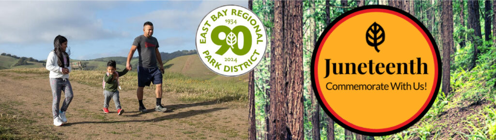
Join the Park District to celebrate Juneteenth on June 19. The Park District is celebrating Juneteenth with a Free Park Day and special naturalist-led programs on Wednesday, June 19, which is a state and federal holiday. All are welcome! Juneteenth is the oldest nationally celebrated commemoration of the ending of slavery in the United States. Join the Park District to celebrate and reflect. For more information, visit https://www.ebparks.org/we-celebrate/juneteenth.
––––––––––
A community meetingfor theBriones Pilot Project on June 15 will share feedback on the progress made in the past year and what’s ahead for the project in its second year. The meeting is a chance for attendees to share their views on the pilot project, too. The in-person meeting will be held on Saturday, June 15, at 10 a.m. at the Alhambra Creek Staging Area of Briones Regional Park in Martinez. The Briones Pilot Project is a two-year project created to test new ways to safely share trails amongst bikers, hikers, and equestrians. The project also improves the trail experience for all users while protecting habitat, wildlife, and watersheds. For more information, visit www.ebparks.org/Briones-Pilot-Project.
––––––––––
Enjoy Father’s Day at the East Bay Regional Park on June 16. Celebrate Father’s Day in nature or check out one of the themed activities planned in Regional Parks: Anthony Chabot Campfire: WILD Dads! at 8 p.m. at Anthony Chabot Family Campground, Father’s Day Celebration at 11 a.m. at the Doug Siden Visitor Center at Crab Cove, or Father’s Day Family Hike at 1:30 p.m. at Del Valle. For more information, visit www.ebparks.org/calendar?terms=Father’s+Day.
––––––––––
Celebrate Regional Parks at Lakeside Laps on July 20. Mark East Bay Regional Park District’s 90th and the Regional Parks Foundation’s 55th Anniversary with a 5k, 10k, or half marathon at Lake Chabot Regional Park in Castro Valley. The Regional Parks Foundation event is a fundraiser supporting East Bay Regional Parks. Come celebrate wellness, community, and the beauty of the Regional Parks while enjoying a run along the lake. For more information, visit www.regionalparksfoundation.org/news-events/lakeside-laps.
The East Bay Regional Park District is the largest regional park system in the nation, comprising 73 parks, 55 miles of shoreline, and over 1,330 miles of trails for hiking, biking, horseback riding, and environmental education. The Park District receives an estimated 30 million visits annually throughout Alameda and Contra Costa counties in the San Francisco Bay Area.
On this National Trails Day see how all 63 national parks rank for hiking, most trails, most miles of trails & most visitors
By KURU Footwear Media Team
National parks are a national treasure—and Americans know it.
In fact, the National Park Service saw 325.5 million recreation visits in 2023 (that’s up more than 13 million visitors from the previous year!), and almost half of Americans (48%) say visiting the national parks is on their bucket list.
National parks help preserve and protect many of our nation’s stunning natural landscapes, so we can behold the beauty for years to come—often through one of thousands of breathtaking hikes.
With summer coming up and kicking off (unofficially) with Memorial Day weekend in May, we wanted to dig into data and find the top 10 best national parks for hiking to help Americans discover their next adventure.
Which National Parks are the Best for Hiking?
With so many show-stopping trails in the U.S. National Park System (over 44,000 combined miles of them!), we knew we needed to narrow it down.
To find our top national parks for hiking, we looked at several metrics: high number of trails, miles of trails, and a high average trail rating score. We also found the crowd density in each park by comparing the average number of daily visitors with the acreage of the park.
Here’s what we found!
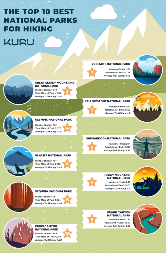
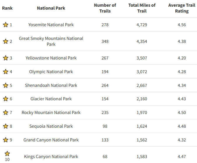
Yosemite National Park takes our #1 slot with 278 trails, 4,729 miles of trail, and a 4.56 average trail rating. Located in the Sierra Nevada mountains of California, Yosemite is known for its iconic and striking Half Dome, tall waterfalls, and giant Sequoia trees.
Source: KURU Footwear
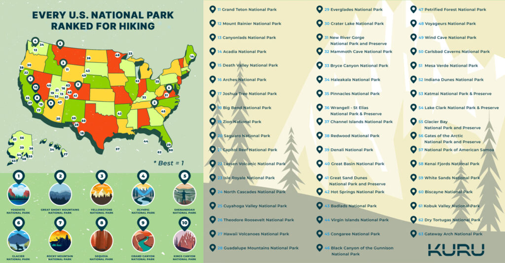
Let’s dig into a more detailed breakdown of parks ranked by number of trails, miles of trails, and annual visitors! Every National Park Ranked for Hiking
Here are our rankings of all 63 national parks based on our metrics. Total mileage was rounded up to the nearest whole mile for the purposes of the table.
As a note, our rankings are based on specific metrics, but everyone’s priorities are unique! So, when it comes time for your national parks trip, feel free to reference this list while ultimately choosing the parks that most inspire you. We feel every national park is worth a visit!
Source: KURU Footwear
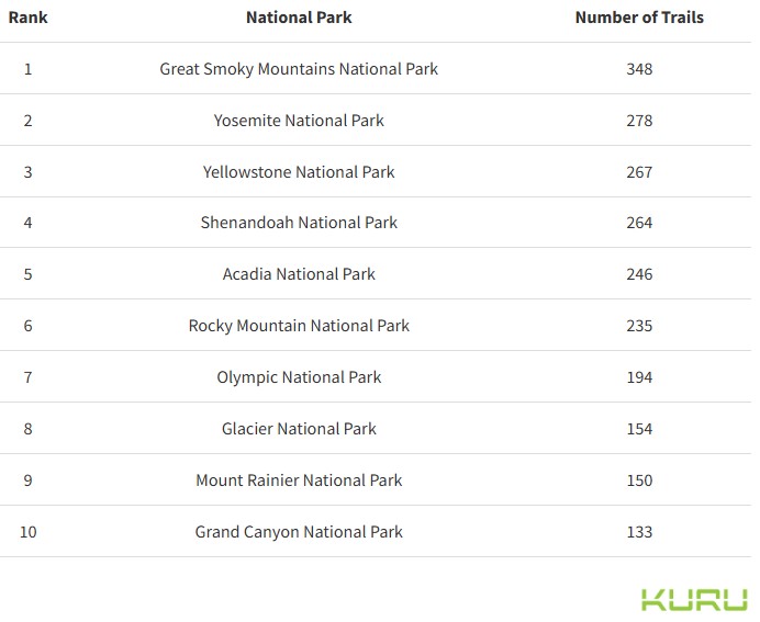
Which National Parks Have the Most Trails?
The national park system offers a tremendous total of 4,155 trails. Even if you ambitiously decided to hike one each day with no days off, you’d need a whopping 11 years to do it!
But if you’re looking for hiking options for the whole family, choosing a park with a high number of trails is a smart way to ensure there’s something for everyone.
Source: KURU Footwear
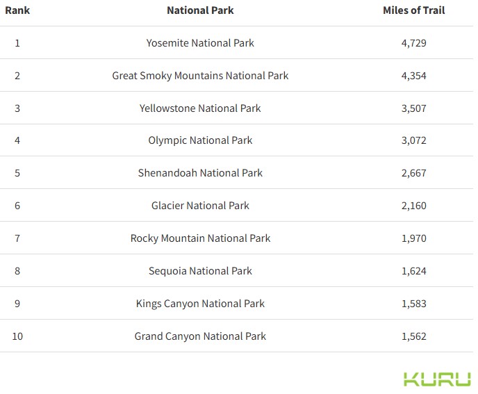
Which National Parks Have the Most Miles of Trails?
When mileage matters most (or you’re just hoping to get your steps in!) choosing a park with plenty of miles of trails might be your best bet.
With an impressive 44,370 combined miles of trails within national parks, you certainly won’t be short of options. The longest trail in the National Park System is the North Country Trail—spanning 4,600 miles across eight states!
Source: KURU Footwear
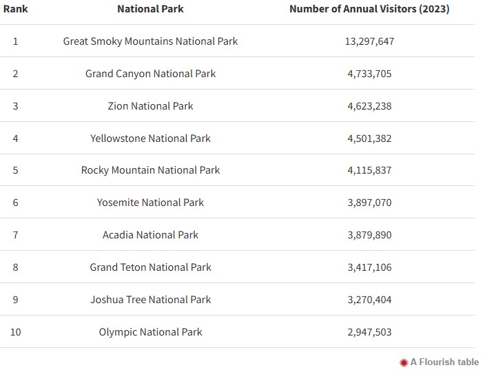
Which National Parks Get the Most Visitors?
Great Smoky Mountains National Park topped our list as the most visited, receiving almost 3 times as many visitors as the second most-visited national park, Grand Canyon National Park!
As you plan your next national park adventure, you may or may not want a lot of people around for the party. Here are the parks with the most visitors in 2023.
Source: KURU Footwear
Final Thoughts & Tips for Hiking in the National Parks
Now that you’ve discovered more info about some of our nation’s top national parks, here are a few tips on how to prepare for a visit to your bucket-list destination!
Do your research. Before you leave, we recommend planning your trip in advance by researching weather, trails you want to prioritize, trail difficulty, length, bathroom stops, and finding any needed lodging.
Wear supportive footwear. Bring a pair or two of comfortable, supportive shoes with plenty of traction, as you could walk many miles per day as you explore.
Stay hydrated. Bring plenty of water to get you through long days. It’s smart for each person to wear a hydration pack along with additional bottles of water if needed.
Use sun protection. When in the sun, apply sunscreen every two hours, wear a hat and sunglasses, and wear moisture-wicking clothing with as much coverage as possible.
Bring a first-aid kit. On the trail, you might not have immediate access to medical care, so bring a kit with you that includes the basics (think disinfectant, bandaids, ace bandage, etc.) until you can get more help.
Whichever park you decide on, we hope you have a spectacular visit!
About the National Parks
Since 1916, the National Park Service has been entrusted with the care of our national parks. With the help of volunteers and partners, we safeguard these special places and share their stories with more than 318 million visitors every year. But our work doesn’t stop there.
We are proud that tribes, local governments, nonprofit organizations, businesses, and individual citizens ask for our help in revitalizing their communities, preserving local history, celebrating local heritage, and creating close-to-home opportunities for kids and families to get outside, be active, and have fun.
Taking care of the national parks and helping Americans take care of their communities is a job we love, and we need—and welcome—your help and support. Learn more on the National Park Service website.
Methodology and Sources
Methodology
We used data from the National Park Service and AllTrails to find the number of available trails in all 63 National Parks in the United States, then ranked each on a scale of best to worst based on number of trails, miles of trails, average trail rating, and park crowd levels.
We used Alltrails to find all of the available trails in each of the 63 National Parks, and analyzed them based on the following metrics: Number of Trails (Total) Total Distance of Trails (in Miles) Average Trail Rating (1-5 Scale) Number of Annual Visitors (2023) Acreage of the National Park (Public Areas Only) These variables were weighted as follows to achieve our final scores and subsequent rankings: (40%) Number of Trails (35%) Miles of Trail (20%) Average Trail Rating (5%) Park Crowd Levels Each metric was normalized on a 0-1 scale with 1 corresponding to the measurement that would most positively affect the final score. These adjusted measurements were then added together with the weights mentioned above to get a score of 100. Sources 1. AllTrails.com 2. National Park Service – Reports (General) 3. National Park Service – 2023 Recreation Visitors 4. National Park Service – Trails & Hiking 5. National Park Service – Acreage by Park About KURU At KURU, we’re on a mission to help you Heel Better™ with footwear technology designed to relieve foot pain, so you can live a life you love. Since launching our innovative technology in 2008, we’ve received more than 32,000 five-star reviews from thousands of customers who tell us their KURU shoes helped them with conditions (such as plantar fasciitis) and got them back to doing what they love.
Whether you’re hiking in East Bay Regional Parks, venturing into nearby open spaces, or simply relaxing in your own yard, it’s important to be wary of ticks, which are often present in tall grass, brush, and wooded areas. Visitors are encouraged to keep tick safety precautions in mind when visiting East Bay Regional Parks throughout the spring, summer, and fall seasons.
Ticks carry germs that can cause a number of diseases, including Lyme disease. Lyme disease is an infectious disease transmitted by the bite of a tick. It may be treated and cured with early diagnosis, but if not properly treated, it may persist in the body for years. Visit www.bayarealyme.org for more information.
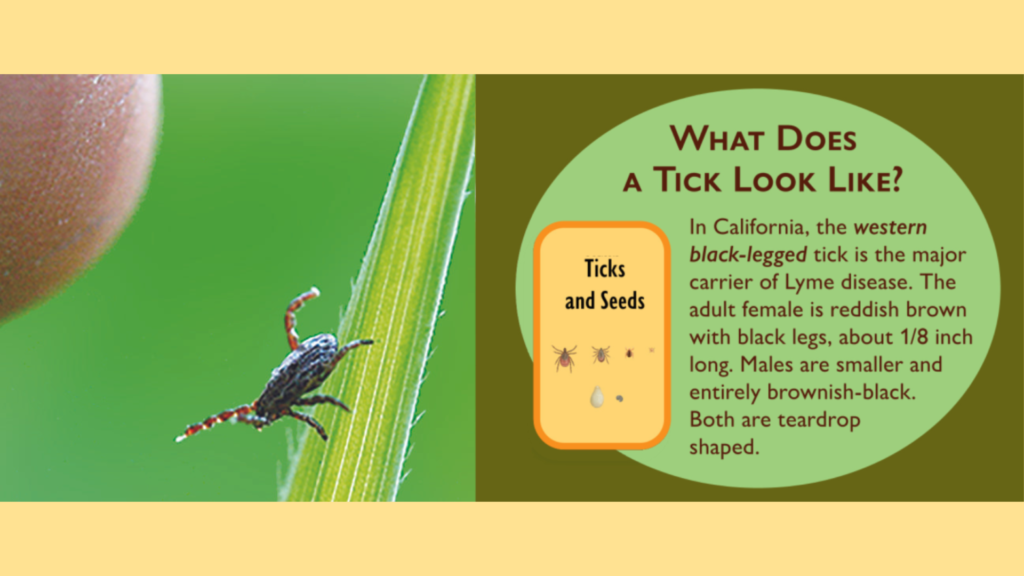
What Does a Tick Look Like? In California, the western black-legged tick is the major carrier of Lyme disease. The adult female is reddish brown with black legs, about 1/8 inch long. Males are smaller and entirely brownish black. Both are teardrop shaped. Most ticks can’t fly or jump. They wait on the tips of grasses and in shrubs along well-used paths. With their front legs outstretched, they easily climb aboard unsuspecting hosts when they brush by.
Tick Safety Tips
Wear long pants, long sleeves, and closed-toe shoes.
Tuck shirt into pants, and pants into socks.
Use insect repellent on shoes, socks, and pants.
Check yourself, your children, and your pets for ticks thoroughly and frequently.
Keep children and pets nearby. For maximum safety, consider keeping your dog on a leash.
Stay on trails. Avoid brush and grassy areas.
What To Do If Bitten By A Tick
Pull the tick gently from the skin using a tissue or tweezers (not with bare hands).
Scrape to remove any mouthparts left behind. An item such as a credit card can be used.
Wash hands and the tick bite with soap and water; apply antiseptic to the bite. Prompt removal of ticks may prevent disease transmission.
See a physician immediately if you think you have found a tick attached to your skin and you have any of the above symptoms. Early symptoms may include a spreading rash accompanied by fever, aches, and/or fatigue.
The East Bay Regional Park District is the largest regional park system in the nation, comprising 73 parks, 55 miles of shoreline, and over 1,330 miles of trails for hiking, biking, horseback riding, and environmental education. The Park District receives an estimated 30 million visits annually throughout Alameda and Contra Costa counties in the San Francisco Bay Area.