


Analysis: Antioch council to consider narrowing redistricting map choices from 13 to two Tuesday night
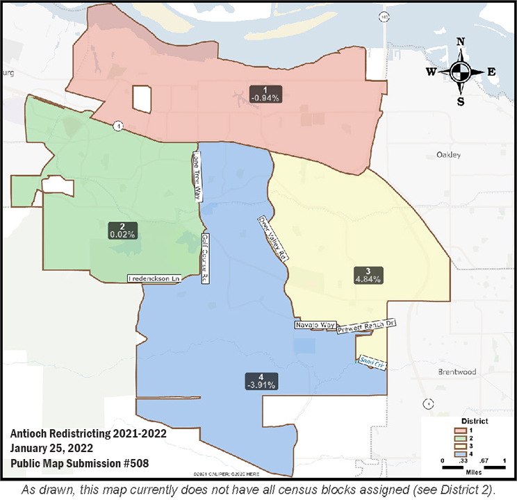
Antioch Redistricting Public Map 508. The Census Tract missing in District 2 is open space and no one lives there, so it doesn’t affect the population figures.
Why is redistricting so important?
Let the people choose their representatives, not the other way around
“It shouldn’t be in the hands of politicians” – Lamar Thorpe
New map doesn’t have to be based on current map; Council should choose maps drawn by members of the public
The Herald recommends Maps 508 (58 revised), 91 and 95 as best alternatives; consultant should also provide details for all publicly submitted maps
By Allen D. Payton
During their meeting Tuesday night, Jan. 25, 2022, the Antioch City Council will consider narrowing down the number of redistricting maps they will consider to just two from the current map approved in 2018. So far, three maps were created and submitted by the consultant, Q2 Data and Research, based on input from the council members, which made slight adjustments to the current map. Q2 provided details for each of the four council districts showing specific streets in each of Maps A, B and C. In addition, members of the public have drawn and submitted n10 alternative maps but Q2 did not provide the same details for each of the four districts for those maps, numbers 34, 39, 49, 58, 87, 91, 95, 503 and now, 508 which is 58 revised. (See agenda item, here – ACC012522 – Redistricting)
Why Redistricting is So Important
Every 10 years, in the year following the Census when the new population figures are determined, district lines must be redrawn to comply with the spirit of one-person-one-vote as intended by the U.S. Constitution. Redistricting should be based on principles not politics. Redistricting is so important because how the new district boundaries are drawn will determine who can run for office and who the voters will elect to represent them.
Thus, we the people should be in control of redistricting, so we get to choose who represents us, rather than the elected officials choosing who it is they will represent. While it would be best to have no population percentage deviation between districts, as it is with redrawing congressional districts, which are required to have a difference of no more than one person, all other districts are legally allowed a maximum deviation of 5% from average.
“It Shouldn’t Be in the Hands of Politicians”
During the districting process in 2018, then-Mayor Pro Tem Lamar Thorpe said, “This is why I hate this process. It shouldn’t be in the hands of politicians.” But neither he nor any other council member proposed forming an independent citizens’ redistricting commission to redraw the council district boundaries, as both Brentwood and Martinez have done. (See related article) So the Antioch Council members will make the decision about their own districts and the public’s opportunity to have a say are during the public hearings on redistricting.
Fortunately, the council had Q2 create a redistricting page on the City’s website, provide an online mapping tool for the public to use to create their own alternative map, and Q2 posted each of the maps for the public to review. Plus, Mayor Thorpe has insisted on having all the maps included in each council discussion, as they were submitted by members of the public. (See Draft Maps and Public Map Submissions on that page)
New Map Doesn’t Have to Be Based on Current Map
At the Council’s Jan. 10th public hearing on redistricting, Karin Mac Donald, owner and Senior Researcher of Q2 said, “there is no law…that says you must start with the districts drawn in the last process.” So, the council can completely scrap the current map, which is based on the 2010 Census figures, and approve a completely new map, which must be based on the 2020 Census population of Antioch which grew by almost 13,000 residents during that time.
Redistricting Principles
During BART’s process, the consultant offered Key Points to Consider in Redistricting, which include:
“Traditional Redistricting Principles – Since decennial redistricting began in the late 1960s, traditional criteria and principles have developed. While the equal population of election districts is the overriding principle there are accompanying goals. In varying degrees, the criteria are compactness, continuity, respect for communities of interest, preserving political subdivisions, and the core of previous districts. All are not of equal weight and all are subordinate to an equal population. Care must be taken not to dilute the voting strength of minorities.
Compactness – Compactness refers to a districts’ geographic shape and how its interior is dispersed within its boundaries. A circle is a perfectly compact shape. In redistricting, the notion of compactness is difficult to evaluate because one begins with irregularly shaped borders and the political subdivisions may be irregular in shape. Geometric measures of compactness are often misleading because geographic features and relationships are more complex than simple geometry. The principle of compactness should be considered functionally and must compete with other criteria.
Continuity – Continuity requires that all parts of a district be connected. Districts can be drawn that are contiguous by way of water or a bridge. While crossing water is allowed it should be minimized as it makes it more difficult to respect communities of interest.
Preserving Political Subdivisions – An attempt should be made to minimize splitting cities and well-defined neighborhoods; and
Respect for Communities of Interest – Communities of interest are subjective and difficult to define. A community of interest has some common thread of shared interest. Those communities can be based on such diverse elements as geography, language, socio-economic-cultural interests, even transportation corridors. Race may be considered, but it may not be the sole reason for drawing a district in a particular manner.”
Use Common Sense, Follow State & Federal Law, No Consideration for Incumbency
Also, according to the BART redistricting process, “new districts should be drawn deliberatively and with common sense. Adherence to traditional redistricting principles and the federal Voting Rights Act will ensure fair and reasonable districts.”
The council must also follow the state’s FAIR MAPS Act when redrawing district boundaries, as Mac Donald pointed out, previously. But the council members do not have to consider to incumbency, in other words, where the current council members live. The Antioch School Board didn’t when they created their first district maps in 2018, resulting in two incumbents living in the same district. The same could occur with the council’s redistricting process when choosing a final map.
Council Should Choose Maps Drawn by Members of the Public
If the Council is going to “whittle it down the number of maps” as suggested by Mac Donald during the Jan. 10th public hearing, they should choose maps submitted by the public in order to reduce both the appearance of political influence and consideration of where incumbents live. Of the nine publicly submitted maps, I recommend that the Council choose among Maps 91, 95 and of course, 58, which I drew and submitted, as finalists.
The online mapping tool for the public only allows the creation of districts using Census Blocks, but the mapping software used by the consultants can be as specific as moving one house between districts. So, if the Council wants to make minor adjustments to any of the publicly submitted maps, Q2 staff can easily accommodate them.
Antioch Redistricting-Public Submission Map #91.
Map 91 Analysis
Map 91 is a combination of the current council districts map and map 58 by connecting all three districts on the south side of Highway 4 to the freeway. However, this map connects District 4 to Highway 4 on the east side of the city, instead. The map also moves the Mira Vista Hills area from District 4 to District 2 which is one reason I like this map, plus the use of major roadways such as Lone Tree Way and Hillcrest Avenue, and the canal as common-sense dividing lines.
While District 4 is less compact than in other maps and looks kind of strange, like a fat seahorse, seated camel or short-necked and legged giraffe, it makes District 3 more compact than it is currently.
CORRECTION: It would be great if the six homes between Hillcrest Avenue and the canal, east of Wildhorse Road could be moved into District 3 instead of District 4, to eliminate the small section that looks like the aforementioned creature’s left ear. But, according to Jane Hood of Q2, Census Tracts cannot be divided and this time, compared to 10 years ago, there are fewer Census Tracts.
While the note beneath Map 91 in the staff report reads, “As drawn this map doesn’t have all census tracts assigned (See District 2)” that’s only the Contra Loma Reservoir in which no resident lives. Since fish don’t yet have the right to vote, adding that census tract won’t change any of the population statistics for that district.
The map also offers one of the lowest population deviations of all the publicly submitted maps. The greatest population deviation in Map 91 is just 1.72% between Districts 1 and 4, which is the least among the three final maps I’m recommending.
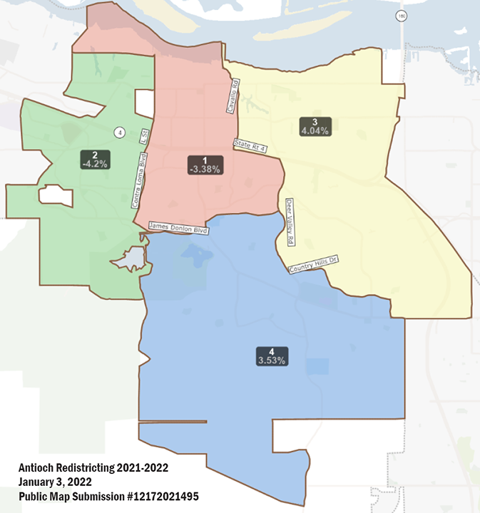
Antioch Redistricting-Public Submission Map #95.
Map 95 Analysis
Of all but one of the public submissions, Map 95 significantly changes things from the current map by dividing the area north of Highway 4 between three council districts, numbers 1, 2 and 3, which is what I like best about this map. Although it goes against the argument made during the 2018 districting process that the residents north of Highway 4 wanted to have their own representative on the council, that hasn’t served that part of the city well, nor did it result in the election of a Hispanic council member, which is why the council switched to district elections in the first place, under threat of a lawsuit they were told they couldn’t win.
That’s in spite of the fact there are and/or have been Hispanic elected officials on both the city council and school board. Another fact is, after the school board switched to district elections, Antonio Hernandez was elected in 2020 to represent the current Area 1, which includes portions of both the north and south sides of Highway 4, giving the board two Hispanic trustees. The other, Trustee Mary Rocha, has not yet run in a district election, but lives in Area 5 and whose seat is up in November. (See current Antioch School Board Trustee Area Map)
The comment provided by the creator of Map 95 reads, “It results in three council members representing the waterfront instead of just one. It also serves to more unify the city between older parts and newer parts instead of dividing it like the current districts do with just one district north of Highway 4. It also combines the Mira Vista Hills area south of James Donlon Blvd. with the older areas north of James Donlon Blvd. and the newer area west of Somersville Road which is more of a Community of Interest.”
The move of the Mira Vista Hills area south of James Donlon Blvd. from District 4 to District 2 is another reason I like this map, plus the use of major roadways and the canal as common-sense dividing lines.
The note beneath Map 95 is that below Map 91 and for the same reasons dealing with not including the Contra Loma Reservoir in which no resident lives, unless there’s a secret Navy Submarine base in it that the public is unaware of.
The greatest population deviation in Map 95 is 8.24% between Districts 2 and 3, which is the most among the three finalists I support.
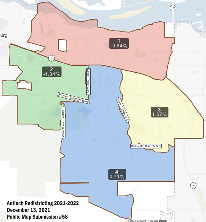
Antioch Redistricting-Public Submission Map #58.
Map 58 Analysis
Except for District 1, Map 58 changes things significantly from the current map, connecting all the three other districts to Highway 4. It makes Districts 2 and 3 more compact and primarily uses the major roads of Lone Tree Way, James Donlon Blvd. and Hillcrest Avenue/Deer Valley Road to separate Districts 2, 3 and 4. As with Map 95 it also moves the Mira Vista Hills area south of James Donlon Blvd. from District 4 into District 2 which makes more sense.
While Map 58, as drawn, divides the homes in the same homeowners’ association along Prewett Ranch Road east of Deer Valley Road, between Districts 3 and 4, up to 992 residents in the older homes on the south side of the street can be moved from District 4 into District 3, and still keep District 3 within the 5% population deviation from average.
CORRECTION: It would be great if the dividing line for Districts 3 and 4 could be between the homes in the newer subdivisions in the Sand Creek area and the homes in the neighborhoods along Prewett Ranch Drive. But that would require splitting up a Census Tract.
The greatest population deviation in Map 58 is currently just 2.91%, also between Districts 2 and 3. However, if the homes on the south side of Prewett Ranch Drive are moved into District 3, the deviation would increase.
Map 508 (58 Revised)
A revised Map 58 was drawn and submitted Monday night, and is labeled #508, did part of that, by moving some homes on the south side of Prewett Ranch Drive east of Deer Valley Road from District 4 into District 3. In addition, Map 508 moves the homes on the south side of James Donlon Blvd. between Lone Tree Way and Tabora Drive, as well as the Contra Loma Reservoir area from District 4 into District 2.
The changes increase the population deviation to 8.75%. But that should be acceptable, as it leaves District 4 with the least current population, which again, is expected to have the greatest population growth with the new homes in the Sand Creek area over the next decade.
Public Hearing Tuesday Night, Jan. 25
The council meeting begins at 7:00 p.m. immediately followed by the public hearing on redistricting at 7:05 p.m. and can be viewed in-person in the Council Chambers at 200 H Street and are televised live on Comcast channel 24, AT&T U-verse channel 99, or live stream at www.antiochca.gov/government/city-council-meetings.
Public Comments
Members of the public wishing to provide public comment may do so one of the following ways (#2 pertains to the Zoom Webinar):
- Fill out an online speaker card by 3:00 p.m. the day of the Council Meeting located at: , https://www.antiochca.gov/speaker_card.
- Provide oral public comments during the meeting by clicking the following link to register in advance to access the meeting via Zoom Webinar: https://www.antiochca.gov/speakers
– You will be asked to enter an email address and a name. Your email address will not be disclosed to the public. After registering, you will receive an email with instructions on how to connect to the meeting.
– When the mayor announces public comments, click the “raise hand” feature in Zoom. For instructions on using the “raise hand” feature in Zoom, visit: https://www.antiochca.gov/raise_hand. When calling into the meeting using the Zoom Webinar telephone number, press *9 on your telephone keypad to “raise your hand”. Please ensure your Zoom client is updated so staff can enable your microphone when it is your turn to speak.
- Email comments to cityclerk@ci.antioch.ca.us by 3:00 p.m. the day of the Council Meeting. The comment will be read into the record at the meeting (350 words maximum, up to 3 minutes, at the discretion of the mayor). IMPORTANT: Identify the agenda item in the subject line of your email if the comment is for Announcement of Community Events, Public Comment, or a specific agenda item number. No one may speak more than once on an agenda item or during “Public Comments”.
All emails received by 3:00 p.m. the day of the Council Meeting will be entered into the record or the meeting. Speakers will be notified shortly before they are called to speak.
the attachments to this post:

Antioch-Redistricting-Public-Map 508

ACC012522 – Redistricting

Map 58 Revised