


Contra Costa Supervisors vote 5-0 to finalize 2021 redistricting map
Contra Costa Board of Supervisors approved the 2021 Redistricting Map D. Source; Contra Costa County
Only 93 people provided public input, nine alternate maps submitted
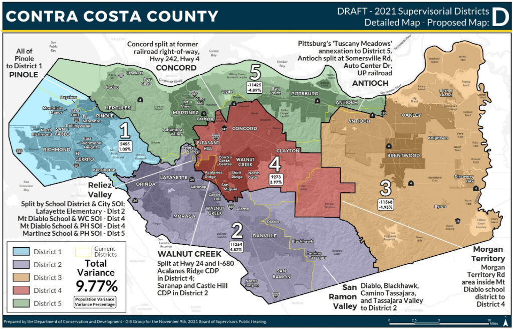
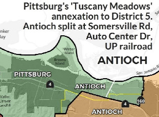
Antioch split between Districts 3 and 5 along Somersville Road, Auto Center Drive and the Union Pacific Railroad right-of-way
By Daniel Borsuk
During their final public hearing for the 2021 redistricting process on Tuesday, Nov. 23, the Contra Costa County Board of Supervisors voted 5-0 to approve the 2021 Redistricting Map D on Tuesday that shows Supervisor Candace Andersen’s District 2 and Supervisor Federal Glover’s District 5 gaining territory at the expense of District 3 Supervisor Dianne Burgis and District 1 Supervisor John Gioia. (See agenda item D.1)
The supervisors’ action on the final redistricting map beat the mandatory Dec. 15 deadline by 22 days after county officials conducted a series of public hearings and workshops that drew meager citizen input.
“For the six workshops a total of 21 individuals provided public comment either in person or by Zoom or phone call; and an additional 72 individuals were on the Zoom or phone call in portions of the workshops but chose not to speak,” a county document stated in defense of the public participation. A total of nine public submissions of alternative maps were included in the process. (See related article)
No matter how uneven the county process might have been in attracting public participation, two districts – District 2 and District 5 – scored the most territory and potential political clout from the decennial redistricting process.
From CCC Board of Supervisors 2021 Redistricting Map D.
Map D keeps Antioch split in two between Districts 3 and 5, as the city currently is, but in different ways. This time the districts are split along Somersville Road and Auto Center Drive and the Union Pacific Railroad right-of-way. Herald publisher Allen Payton asked the supervisors to consider splitting Antioch along the city boundary line with Pittsburg and Highway 4, which he said makes more sense for residents to know what district they live in and to match the current and expected district boundaries for Antioch City Council District 1. Burgis said she tried to make that happen but the population figures to comply with the 5% deviation legal requirement, didn’t work.
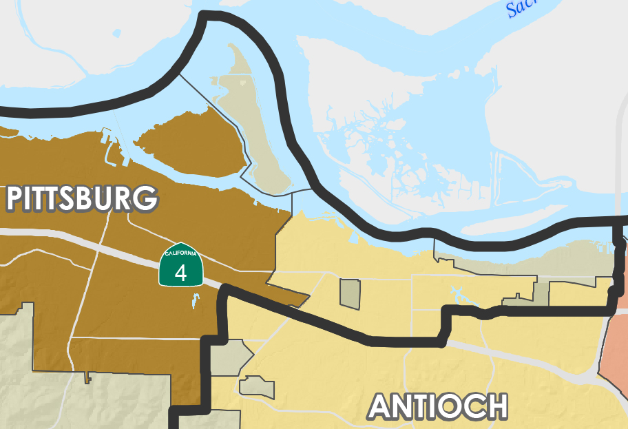
CCC Supervisor 2011 Districts current Antioch-Pittsburg split.
After the final vote on the map, Board Chair Burgis of Brentwood put a positive spin on the two-month redistricting activity stating.
“The Contra Costa County Board of Supervisors thanks the community for its participation in this decennial process,” she said. “We have been committed to a robust Redistricting and public outreach process with public hearings, a dedicated website at CoCoRedistricting.org, public workshops, and multiple ways for the public to share input, including an online mapping tool to draw maps and submit comments. We want to thank you for staying informed and playing a role in this important process.”
“I’d like you to not vote on this today,” requested Sherrill Grower, one of three persons who spoke at Tuesday’s meeting. “I feel like this map disenfranchises the public particularly along the northern waterfront. I am not pleased with the proposed district boundaries.”
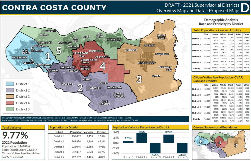
Map D with population statistics. Source: Contra Costa County
With the new map, District 4 now covers most of Walnut Creek split at Highway 24 and Interstate 680 with District 2 Supervisor Andersen representing the other portion of the city, primarily Rossmoor.
District 4 underwent the smallest population gain of the five districts with a 1.65 percent increase from 2010 to 2020, to 229,348 residents, according to Census data. Whites represent 51.7 percent of District 4’s population followed by Latinos at 22.4 percent, Asians at 15.2 percent, Blacks at 3 percent and 7.7 percent for others.
District 4 Supervisor Karen Mitchoff, who has announced she won’t seek re-election in 2022, also saw the city of Concord, which is in District 4, split with Glover’s District 5 by Highways 4 and 242 and the former railroad right-of-way.
Mainly because Andersen’s District 2 experienced the biggest population gain of any of the other districts, from 2010 to 2020 it gained more territory. Population-wise, District 2’s population rose from 218,017 in 2010 to 243,565 in 2020. Whites make up 55 percent of the district’s population followed by Asians at 28 percent, Latinos at 8.5 percent, and Blacks at 1.6 percent and others at 6.8 percent.
District 2 will now cover Tassajara Valley, Blackhawk, Diablo and Camino Tassajara, all formerly were represented by Supervisor Burgis.
District 3, which saw its population rise 2.85 percent to 203,711 from 2010 to 2020, covers most of Antioch and the other growing cities of Brentwood and Oakley and communities of Bethel Island, Knightsen, Discovery Bay, and Byron.
District 2 also contains the cities of San Ramon, Danville, Moraga, Lafayette, and Orinda. The census designated Alamo, Blackhawk, Diablo, Camino Tassajara, Saranap, and Castle Rock as contained in District 2.
In addition to the cities of Pleasant Hill and Clayton, the Contra Costa Centre, Acalanes Ridge, Shell Ridge, San Miguel and North Gate are in District 4.
Glover, who offered no comment on the final redistricting map, also gained territory. He not only retains the Northern Waterfront, an area now under planning study for future industrial and economic development from Crockett to Oakley, but District 5 now, no longer has a portion of Pinole that was formerly split by District 1’s Gioia and District 5’s Glover.
Not mentioned publicly, District 5 is due to benefit economically and demographically when bulldozers rev up at the former Concord Naval Weapons Station where the Seeno Company has won City of Concord approval to build 13,000 housing units and commercial developments on 5,046 acres on the former Naval weapons base property in north Concord. Construction should be well underway over the next 10 years.
Based on U.S. Census data, District 5’s population increased from 203,744 in 2010 to 228,463 in 2020. Thirty-five percent of the district’s population is Latino, 27.5 percent is White, 17.9 percent is Asian and 12.4 percent is Black.
Supervisor John Gioia was pleased with the redistricting results, especially when more urban-like district contains the cities of Richmond, San Pablo, El Cerrito, and Pinole. Kensington, North Richmon, East Richmond Heights, El Sobrante, Rollingwood, Tara Hills, Montalvin Manor, and Bayview are also included in District 1.
District 1’s population grew from 203,437 persons in 2010 to 224,726 in 2020, according to U.S. Census data. Latinos represent 40.9 percent of the district’s population followed by whites at 21.7 percent, Asians at 16.8 percent and Blacks at 16.8 percent
“The boundaries are very similar to our local transportation district,” observed Gioia. “There is no gerrymandering.”
Overall, Contra Costa County’s population increased 11.4 percent to 1,168,064.
Allen Payton contributed to this report.
the attachments to this post:

CCCBOS Redistricting Map D with stats

CCC Supervisors 2011 Districts Antioch-Pittsburg split

CCCBOS Redistricting Map D Pitts-Ant split