Join Mayor Ron Bernal for a Walk and Talk at Black Diamond Mines Regional Preserve!
Get out and connect with your community while exploring the beautiful trails of Black Diamond Mines. This is your chance to chat directly with Mayor Bernal about what matters to you.
Saturday, January 10th, 2026 10:00 a.m. – 12:00 p.m.
Black Diamond Mines (Antioch) Upper Parking Lot, at the end of Somerville Road, 1 mile past the entry kiosk.
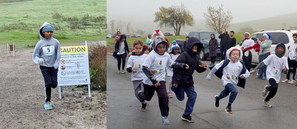
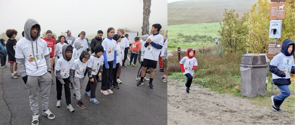
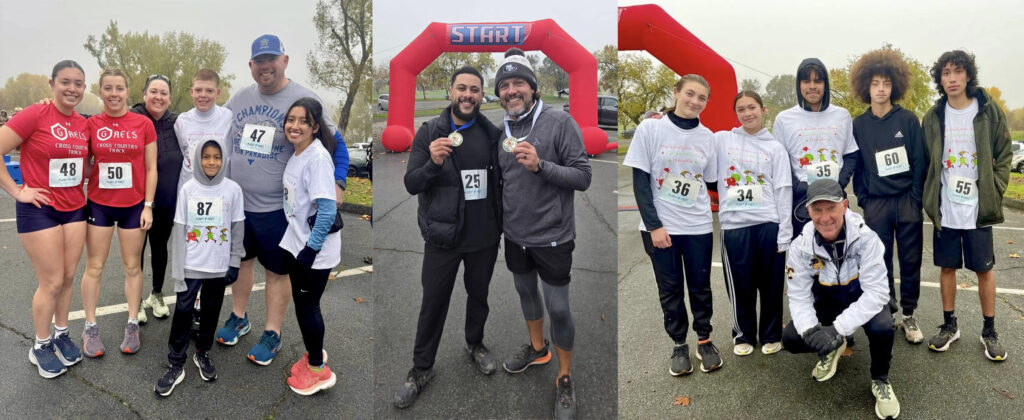
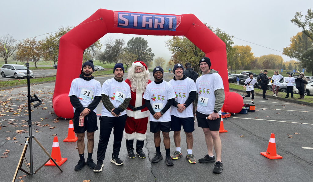
Students participated in the 1-mile and 3-mile runs and race with Santa on Saturday, Dec. 13, 2025. All photos courtesy of Antioch Unified School District unless noted.
By Allen D. Payton
According to the Antioch Unified School District, “despite chilly conditions, hundreds turned out for the 49th annual Holiday Run & Walk for Health.
“Founded by Tom Torlakson, former State Superintendent of Schools, the event was held on Saturday, Dec. 13, 2025, at Contra Loma with many of our students running the race, including several high school cross country runners.
“Hosted by the Kiwanis Club of the Delta-Antioch and the Rotary Club of the Delta, proceeds benefit our schools and community.”
Race Director Mike Green shared the following results of two races:
Male 3-Mile Race Winners
Giancarlo Olmedo – 15 years old – 19:31.5
Jailen Johnson-Truitt – 18 – 20:09.3
Dennis Gavrilenko – 22 – 20:26.3
Female 3-Mile Race Winners
Valeria Espinoza – 20 – 19:43.0
Kylie Wisely – 17 – 21:27.8
Jaelyn Wilkins – 17 – 22:53.8
Santa (Joe Goralka) with runners from the Antioch Police Department. Photo by Tom McNell
Green offered “Special thanks to East Bay Regional Parks District / Contra Loma for helping us host this event. Thank you to the Race Directors from Rotary and Kiwanis Clubs of the Delta, and to our event sponsor, Dr. Ali Shirani.”
Enjoy a free, family-friendly adventure in the East Bay Regional Parks
Includes Volunteer Planting Opportunity at Contra Loma and Hike at Black Diamond Mines in Antioch
By Jen Vanya, Public Information Specialist, Public Affairs, EBRPD
For more than a decade, the East Bay Regional Park District has encouraged the community to embrace Green Friday—the day after Thanksgiving—as an opportunity to get outside, enjoy fresh air, and reconnect with nature in the East Bay Regional Parks.
“Green Friday is a healthy and meaningful way to spend the day after Thanksgiving,” said Jessica Sloan, the Park District’s volunteer program supervisor. “It’s a chance to enjoy time with family and friends in the outdoors or give back by participating in one of our volunteer clean-up projects. However you choose to spend it, the day is all about celebrating and caring for our natural spaces.”
On Green Friday, November 28, all Park District entrance and park use fees are waived, including parking, boat launching, and fishing, as well as entrance to Ardenwood Historic Farm. Fees are still in effect for state fishing licenses, watercraft inspections, and concessionaires, such as the Tilden Merry-Go-Round.
Green Friday is part of the #OptOutside movement to promote health-focused alternatives to Black Friday shopping.
Green Friday activities in Regional Parks include:
Volunteer Planting Opportunity, 9 a.m. at Contra Loma in Antioch (registration requested)
Green Friday Hike, 9 a.m. at Black Diamond Mines in Antioch
Green Friday Hike Amongst the Trees, 9 a.m. at Reinhardt Redwood in Oakland
Green Friday Gratitude Hike, 10 a.m. at Sunol Wilderness in Sunol
Green Friday Hike, 10:30 a.m. at Coyote Hills in Fremont
The East Bay Regional Park District is the largest regional park system in the nation, comprising 73 parks, 55 miles of shoreline, and over 1,330 miles of trails for hiking, biking, horseback riding, and environmental education. The Park District receives an estimated 30 million visits annually throughout Alameda and Contra Costa counties in the San Francisco Bay Area.
Former EBRPD GM Sabrina Landreth to seek counsel for possible legal action against the District’s Board. Photo: EBRPD
Controversy at EBRPD: General Manager didn’t jump, claims she was pushed out by Board, seeks legal action
Sabrina Landreth said she was “constructively terminated” and “could not perform…job under a Board of Directors which was not exercising appropriate governance and operates without adequate checks and balances.”
By Sam Singer, President, Singer Associates Public Relations
Landreth resigned from her position as EBRPD General Manager this week but said she was “constructively terminated” by the Board which demanded she take actions–which she refused—that would have violated open government and personnel laws, and harmed her professional and personal reputation.
Landreth said she “could not perform my job under a Board of Directors which was not exercising appropriate governance and operates without adequate checks and balances.”
“The Board was demanding that I compromise my integrity and values. I would not do that,’ she said. “I stand by my values and my reputation as a professional administrator for the past twenty-five years.”
“I am proud of my accomplishments during my EBRPD tenure,” Landreth added. “There were many projects I had started and am disappointed not to complete because my time was cut short by the Board.”
Landreth was hired in March 2021 and has served for almost the past five years as General Manager of EBRPD, the largest regional park system in the country. Her contract was renewed in 2024 for an additional five years. She was the first woman to serve as General Manager in the District’s 91 year history. Previously, she held top executive leadership positions managing the cities of Oakland and Emeryville.
Prior to the EBRPD, Landreth served as City Administrator in Oakland from 2015- 2020, where she is credited with strong fiscal management and developing a capital improvement program that included community equity goals and has become a model program for local governments around the country.
Previously, Landreth served as City Manager of Emeryville and as staff in the California State Assembly advancing state and local legislative initiatives.
She serves on the UC Berkeley Goldman School of Public Policy Board of Advisors and a number of community organizations.
When reached for comment, EBRPD Communications and Outreach Manager Kendra Strey responded, “The East Bay Regional Park District has not received a legal claim and cannot comment on pending or threatened litigation.”
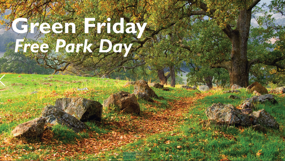
Includes Green Friday Free Park Day at Black Diamond Mines and Contra Loma, Nov. 28
By Dave Mason, Public Information Supervisor, Public Affairs, East Bay Regional Park District
Fall Walks & Strolls. Late fall is the perfect season to get outside and explore East Bay Regional Parks. Whether you’re up for a challenging hike or a gentle stroll, there’s something for everyone to enjoy. Embrace the cool weather, crisp air, changing plant colors, and abundant wildlife on these fall walks and strolls. Let the natural beauty of the East Bay rejuvenate your spirit on these unforgettable fall adventures.
For more information, visit ebparks.org/calendar and search for walks and strolls.
Anthony Chabot Regional Park (left). Credit: Kevin Fox. Tilden Regional Park Botanic Garden (right). Credit: Jacob Drueckhammer. Source: EBRPD.
Green Friday Free Park Day. Celebrate Green Friday — the day after Thanksgiving — with a free park day in East Bay Regional Parks! Fees are waived for parking, boat launching, and fishing — only state fishing licenses, watercraft inspections, and concession fees apply. Admission to Ardenwood Historic Farm is also waived for Green Friday! The East Bay Regional Park District celebrates Green Friday to encourage the public to spend time in nature. It’s a great way to spend time with family and friends the day after Thanksgiving.
Contra Loma Regional Park. Source: EBRPD. Credit: I.P. Jones
The Park District is also facilitating cleanup projects on Green Friday. Instead of (or after!) spending the day searching for special savings on holiday gifts, use the day off to give back to nature through a service project. The Park District is facilitating two clean-up events for all to join: At both Contra Loma Regional Park in Antioch and Quarry Lakes Regional Recreation Area in Fremont, volunteers will be removing invasive plants at designated worksites between 9 a.m. and noon. Registration required.
Age Restrictions: Youth under the age of 18 must have a signed permission by parent or legal guardian. Youth under the age of 13 must be accompanied by an adult.
What to Bring: Water bottle, gloves, and sun protection.
What is Provided: Necessary tools.
Weather Notes: Heavy rain or wildfire smoke cancels.
Native American Heritage Month. Celebrate Native American Heritage Month by recognizing and honoring the Indigenous peoples who have inhabited this land since time immemorial. Indigenous peoples and tribal citizens in the East Bay continue to be closely connected to the land through distinct traditions, unique languages, and sophisticated knowledge systems.
Individuals from the Ohlone, Bay Miwok, Delta Yokut, and many others, continue to live on this land, practicing their culture and traditions to this day. Immense gratitude is extended to the many Native peoples who have contributed — and continue to contribute — their perspectives, voices, history, and culture to our programs.
In addition to honoring veterans, service members and retirees with free park entrance on Veterans Day, the Park District honors the Distinguished Veteran Pass, which is administered by California State Parks. Veterans with a Distinguished Veteran Pass receive free day-use parking and free entry to Ardenwood Historic Farm, not including special events.
Plus, the Regional Parks Foundation offers a discounted Special Access Membership for veterans.
Regional Park Membership — the Perfect Gift for Nature Lovers. This holiday season, give a gift that inspires adventure all year long — a Regional Parks Foundation Membership. Members enjoy a personalized Membership Card, free day-use parking, free swimming, camping discounts, free admission to Ardenwood Historic Farm on non-event days, free home delivery of the Park District’s Regional in Nature activity guide and the Foundation’s Compass magazine, and more. Consider the Angler level for free fishing and boat launch.
The East Bay Regional Park District is the largest regional park system in the nation, comprising 73 parks, 55 miles of shoreline, and over 1,330 miles of trails for hiking, biking, horseback riding, and environmental education. The Park District receives an estimated 30 million visits annually throughout Alameda and Contra Costa counties in the San Francisco Bay Area.
ANTIOCH, CA — The City of Antioch, in partnership with Rising Juntos, invites the community to celebrate the grand reopening of Contra Loma Estates Park on Saturday, November 15. The free, family-friendly event will take place from 12:00–2:00 PM at the corner of Mahogany Way and Manzanita Way, and will feature music, games, raffles, food, guided park tours, speeches and a ribbon cutting ceremony.
According to Parks and Recreation Department staff, “After years of community advocacy, Contra Loma Estates Park is finally re-designed by and for the community. Bring the whole family to celebrate!”
Después de años de esfuerzo de la comunidad, el Parque Contra Loma Estates finalmente se rediseñó por y para la comunidad. ¡Lleve a toda la familia a celebrar!
Located in the heart of North Antioch’s Sycamore neighborhood, Contra Loma Estates Park has long been a central focus for residents seeking safe, vibrant public space. The revitalization effort began in 2013, when Rising Juntos led a community needs assessment that identified the park as a top priority for improvement. In response, the Antioch City Council funded a community-designed playground in 2015 and new basketball courts in 2018.
Building on that foundation, the City of Antioch and Rising Juntos partnered to secure Proposition 68 funding to complete the community’s long-term vision for the park. Now, after more than a decade of advocacy, planning, and partnership, Contra Loma Estates Park is fully renovated and ready to serve as a hub for families, youth, and neighbors of all ages.
“This reopening represents the best of Antioch: community leadership, meaningful partnership, and shared investment in public space,” said City Manager Bessie Marie Scott. “Contra Loma Estates Park reflects a decade of commitment from residents, Rising Juntos, and our City team. We are proud to stand with the Sycamore community in celebrating a space that belongs to everyone.”
Rising Juntos Executive Director Rhea Elina Laughlin added, “This project is an example of what we can achieve when residents and city staff work together toward the community’s vision. We are thrilled to inaugurate this new park, designed by and for the neighborhood.”
Rocheall, a longtime Antioch resident and Rising Juntos member, shared, “I am so excited about the park re-opening. My son can’t wait to use the basketball courts and the renovated walking path. I am so happy that our neighborhood park has restrooms for families. This is a huge win for our community. Our children and future generations will now have a beautiful and safe park.”
For more information: 510-368-4544.
About Rising Juntos
The Mission of Rising Juntos is to build power for racial, economic and health justice for children and families in Contra Costa County. Led by a volunteer membership made up of resident leaders across Contra Costa County, their multicultural, intergenerational membership brings lived experience with systemic injustice and deep understanding of community needs. Rising Juntos members are the experts and driving force of their work. They have four Focus Areas: Housing and Economic Security, Healthy Parks and Communities, Equitable Representation, and Access Racial and Immigrant Justice.
Former EBRPD General Manager Sabrina Landreth (Source: EBRPD) and Acting GM Max Korten. (Source: LinkedIn)
Sabrina Landreth leaves post after less than five years; Deputy General Manager Max Korten appointed Acting GM
By Kendra Strey, Communications Manager, EBRPD
OAKLAND, CA — Sabrina Landreth resigned from her position as General Manager of the East Bay Regional Park District on November 6, 2025. Following a closed session on Saturday, Nov. 8, the EBRPD Board of Directors voted unanimously to appoint current Deputy General Manager Max Korten as the Acting General Manager.
Landreth served as General Manager since March 2021, coming into the position during the pandemic and immediately working tirelessly to improve the Regional Parks, make key acquisitions including Pt. Molate in Richmond, and ensure parks are accessible and welcoming to all members of the community. Under Landreth, the Park District modernized and strengthened the agency’s leadership infrastructure, assembling talent across all Divisions to ensure the agency is well positioned for a bright future.
“The Board of Directors is incredibly thankful for Ms. Landreth’s service and her numerous substantial contributions to the operations of the Park District,” Board President John Mercurio said. Next steps on the hiring process are yet to be determined.
Beginning as a parks and open space superintendent in 2014, he served as director and general manager from 2016-24, responsible for 34 open space preserves, 45 parks, and 150 employees. Prior to that he worked as the natural resources program director for Conservation Corps North Bay and as a backcountry ranger and trail crew supervisor for the Bureau of Land Management and the U.S. Forest Service. Korten graduated from the University of California, Santa Cruz with a degree in Environmental Studies, and went on to obtain a Master of Science in Natural Resources from Humboldt State University. He also enjoys volunteering as a coach for his son’s soccer team and as a board member for Together Bay Area.
The East Bay Regional Park District is the largest regional park system in the nation, comprising 73 parks, 55 miles of shoreline, and over 1,330 miles of trails for hiking, biking, horseback riding, and environmental education. The Park District receives an estimated 30 million visits annually throughout Alameda and Contra Costa counties in the San Francisco Bay Area.
By Dave Mason, Public Information Supervisor, Public Affairs, East Bay Regional Park District
When Leaves Fall, Fire Risks Rise. Fall is peak fire season, due to dried-out vegetation from summer heat and offshore Diablo winds that historically occur September through November. Be aware of fire hazards, restrictions, and Red Flag Warnings. Wildfire safety remains one of the East Bay Regional Park District’s top priorities.
Photos: EBRPD
Fire Safety Tips
Follow all fire safety rules.
No smoking or vaping in parks.
No fireworks.
Report fire hazards and call 911 if you see an active fire.
Photos: EBRPD
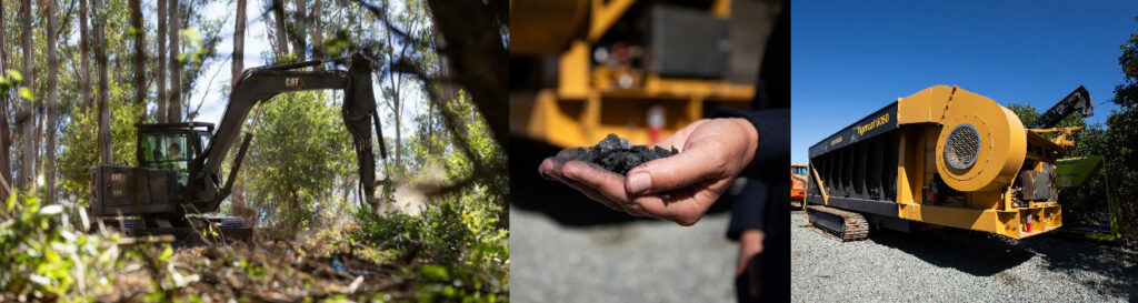
667-Acre Fuels Reduction Project Complete. For the past three years, the East Bay Regional Park District has been thinning brush and hazardous trees on 667 acres at Anthony Chabot Regional Park to reduce fire risk. This groundbreaking effort — the first of its kind in California — included large-scale eucalyptus removal and the use of a climate-friendly carbonizer to dispose of debris with minimal emissions. Reducing fire fuels is essential to slowing wildfires and giving firefighters time to stop them before they grow out of control.
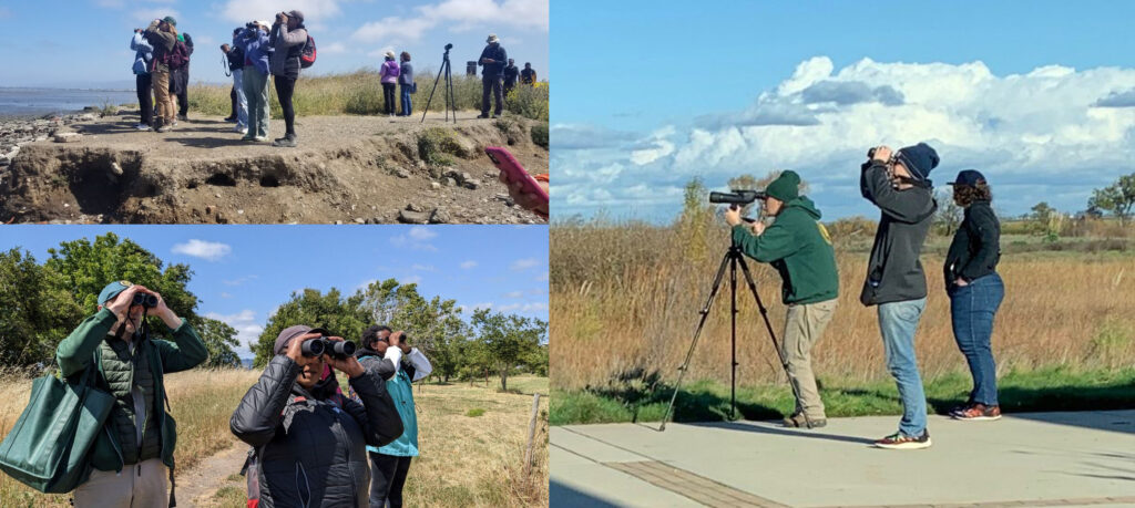
Fall Is a Great Time for Birding. Fall and winter are prime seasons for birding in East Bay Regional Parks. From wetlands to woodlands, diverse habitats host migrating and nesting birds, as well as wintering waterfowl and shorebirds. It’s a perfect time to spot unique species and enjoy this beloved outdoor pastime.
The Park District offers birding programs for all experience levels, including hikes, kayak excursions, and community science events. Birdwatching is more accessible than ever with events like the Great Backyard Bird Count (Feb. 13-16, 2026) and apps like Merlin and eBird. For information, visit ebparks.org/calendar and search “Birding.”
Photos: EBRPD
Looking for Love. With the onset of cooler fall weather, male tarantulas leave their burrows to find females. They tap on the burrow entrance to signal a mate, and if she emerges, they mate. Life isn’t easy for male tarantulas. After mating, the female can sometimes kill the male, though this is infrequent. Even if he survives, he will soon die. Male tarantulas only live for seven to 10 years, while females can live as long as 30 years.
Tarantulas in the East Bay range from dark brown to light tan and are spotted most often in the late afternoon or early evening, after the day’s heat fades. Join a naturalist program or hike to learn more about these fuzzy friends — or possibly even see one. For more information, visit ebparks.org/calendar and search “Tarantulas.”
Photos: EBRPD
Celebrate Corn at Ardenwood’s Harvest Festival! The story of corn begins with a wild grass called teosinte, first cultivated in central Mexico around 9,000 years ago. Today, corn — also known as maize — nourishes communities around the globe. From popcorn and cornbread to polenta, hominy, cereal, and of course, corn on the cob, many popular foods trace back to this remarkable plant.
To learn more about corn, attend Ardenwood’s annual Harvest Festival on Oct. 11-12, from 10 a.m. to 4 p.m., where visitors can walk through the cornfields and participate in the ancient autumn ritual of harvesting maize — and even take home a few ears of corn (one-bag-per-person limit). Enjoy seasonal activities, including cider pressing, live music, and historic crafts, and ride a narrow-gauge train. Free for participants ages 3 and under.
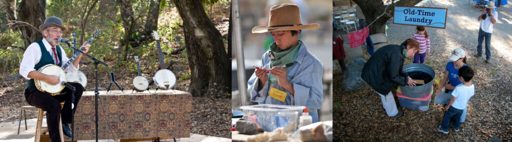
Step Back in Time at the Sunol Heritage Festival. Celebrate the rich heritage of the Sunol wilderness at a lively, family-friendly festival on Saturday, Oct. 18, from 11 a.m. to 3 p.m., filled with hands-on history, live music, crafts, Ohlone stories, and fun for all ages. Visitors can connect with the past through activities that highlight the history, traditions, and cultures of the region — from crafting miniature tule boats, to making traditional pine nut bracelets and learning about ranching brands while creating a “branded” bandana.
Families can also try their hands at old-time laundry, play Ohlone and Victorian-era games, meet Poppy the wooden milking cow, practice lasso skills, and more. Guests are encouraged to bring a picnic and enjoy the park’s natural setting while taking part in the festivities. Parking is $5.
Ardenwood Halloween Festivities. Each year Ardenwood comes alive in October with the frightful Haunted Railroad and community pumpkin patch. Ardenwood offers nighttime train rides through its haunted forest. The ride is spooky — not scary — and is designed especially for children under 12. Tickets sell out fast! Registration required. For more information, visit spcrr.org.
Ardenwood’s annual pumpkin patch is operated by Dig Deep Farms, which also offers Halloween-themed arts, crafts, and games. Pumpkin patch admission does not include admission to Ardenwood Historic Farm.
The East Bay Regional Park District is the largest regional park system in the nation, comprising 73 parks, 55 miles of shoreline, and over 1,330 miles of trails for hiking, biking, horseback riding, and environmental education. The Park District receives an estimated 30 million visits annually throughout Alameda and Contra Costa counties in the San Francisco Bay Area.