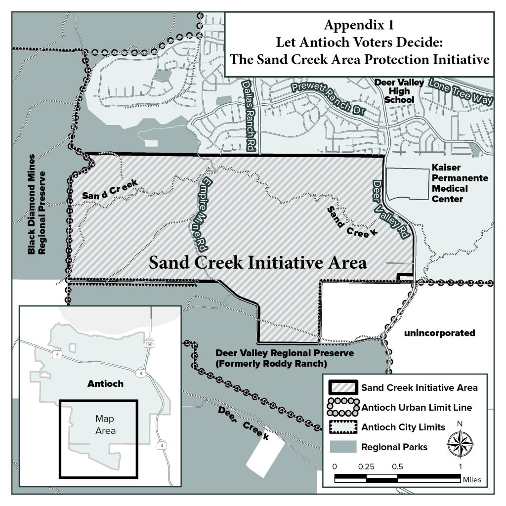
Archive for the ‘Growth & Development’ Category

Supervisors approve major Buchanan Airport mixed-use project, more airport projects planned

Wednesday, April 11th, 2018

Sheriff-Coroner awarded $400,000 in grants

By Daniel Borsuk

Contra Costa Supervisors flashed the green light on Tuesday for county airport officials to ink a long-term lease with a Southern California developer to build a 52,000 square foot, single story mixed-use building at 550 Sally Ride Drive near Buchanan Field Airport in Concord.

The supervisors’ 4-0 action serves as a signal that more commercial and aviation related developments are in the pipeline on county owned property adjacent to the county’s two airports – Buchanan Field Airport and Byron Airport.

District 3 Supervisor Diane Burgis was not in attendance because she was at a business meeting representing the supervisors.

The supervisors’ action on the consent agenda item means that Airports Director Keith Freitas can proceed to execute a long-term lease with Montecito Commercial Group, LLC for the lease of about 3.21 acres of unimproved county-owned property at the south end of Sally Ride Drive.

As part of the supervisors’ action, the developer will receive a mitigated negative declaration attached to the project’s environmental impact report.  During the EIR procedure, the Contra Costa Water District submitted a letter about the developer’s water usage and an easement issue.  Both issues were resolved according to the CCWD.

The county can expect to cash in on the proposed single-story office-warehouse-distribution building.  During the two-year construction period, the county will be paid $1,000 per month, but once construction is completed monthly rent will increase to $4,247 and will be adjusted every year on April 1 based on the Consumer Price Index.

The Montecito lease calls the one-year period beginning April 1, 2022, 2023, 2024, 2025, 2026 any adjustment will not be greater than 75 percent of the CPI factor.  For the one period beginning on April 1, 2028, throughout the lease term, any adjustment to ground rent based on CPI may not be more than 4 percent of ground rent then in effect.

The Montecito development serves as an indication more projects near the county’s two airports are on their way for future supervisors’ review and action, Assistant Airports Director Beth Lee said.  Supervisors are expected to soon consider two large developments proposed for the Byron Airport.  One is a proposed building for aviation use and the other building is for non-aviation use, Lee said.

Lee noted the developer has yet to complete design and other procedural work before the Montecito project can get underway.

Before the Montecito -Buchanan Field development, the last development constructed on county airport property occurred in 2012 at the Byron Airport when the Patriot Jet Team building was constructed, said Lee.

When asked if real estate developers are finally recognizing how county airport projects can generate ideal real estate deals, Lee responded: “We sure hope so. This could mean a major new source of revenue for the county.”

Two State Grants Approved for Sheriff-Coroner

Supervisors approved two major state grants for the Sheriff-Coroner’s Office.

A $300,000 grant from the California Division of Boating and Waterways was awarded to the Sheriff-Coroner for the removal of abandoned vessels and the vessel turn-in program on county waterways.  The grant goes into effect beginning Oct. 1, 2018 and remains in effect when grant funding runs out.  Ninety percent of the funding comes from the state and 10 percent is an in-kind match.

Supervisors also approved a $97,100 grant for the Sheriff-Coroner from the Office of the Attorney General, California Department of Justice, Division of Law Enforcement Tobacco Law Enforcement Grant Program.  The grant will be used from June 1, 2018 through June 30, 2020 to decrease juvenile access and use of tobacco products.

Both grants were approved as consent items.

Council approves 35-home in-fill project by Discovery Builders on split vote

Tuesday, April 10th, 2018

Thorpe, Wilson oppose

By Allen Payton

In other action at their Tuesday, April 10th meeting, the Antioch City Council split on the approval of a 35-home in-fill development project by Discovery Builders, known as the Oakley Knolls. The subdivision will be located off Oakley Road between Willow Avenue and Phillips Lane, next to the Almondridge subdivision in the northeast portion of the city. See the entire staff report and agenda item, here: Oak Knolls Project 04-10-18

Community Development Director Forrest Ebbs offered the report on the project and said staff recommended approval.

Mayor Pro Tem Lamar Thorpe expressed his surprise with the application for the project in light of the lawsuits filed by the same developer against both the city and DeNova Homes with a recently approved project in Antioch. DeNova Homes in turn submitted a letter to the city on Tuesday, with a copy of their lawsuit against Discovery builders.

“The audacity of Discovery Builders,” Thorpe said. “I can’t believe what I’m looking at. I sat down with Seeno, Jr. He was fine with everything. We’re trying to move forward this city…and there’s Discovery Builders standing in the way. It’s almost insulting.”

“The lawsuit Discovery Builders has with DeNova Homes…piece mealing the environmental,” he said to the developer’s representative.

“I’m not sure what you’re referring to,” he responded. “I got this letter three hours ago.”

Interim City Attorney Derek Cole interjected, “We have one developer who has filed a lawsuit against a city…then challenged another developer. Now they’re before the city asking for entitlements.

They’re making arguments that are inconsistent with that. For purposes of your actions, tonight those should be based on the merits.

Councilwoman Monica Wilson said, “I too am perplexed by this proposal. Talk to me about the EIR (Environmental Impact Report). I don’t see that in this process. They’re also asking for a lot of exceptions on this.

Ebbs responded saying, “They’ve determined that every impact can be mitigated. A mitigated negative declaration can be arrived at if they’re going to address each impact. Generally, a neg dec is appropriate for a project of this size. It would not normally trigger an EIR.”

Tiscareno had some questions on setbacks, then said, “I understand the confusion by some of my council mates. We received this same email this afternoon.”

Ebbs responded, “when the lawsuit is against us, we have to defend our own actions.”

The council then discussed and debated Councilwoman Lori Ogorchock’s idea to have more lots allowing for RV parking. They ultimately decided to leave it as was proposed to six lots.

The council then voted 3-2 to approve the project with Mayor Sean Wright, Councilmembers Tony Tiscareno and Ogorchock in favor, and Thorpe and Wilson voting against.

Environmental groups, Antioch residents submit initiative seeking third vote on new home development area

Friday, March 2nd, 2018

By Allen Payton

On Thursday February 8, 2018 a coalition of Antioch residents and community groups, entitled the Antioch Community to Save Sand Creek, submitted the text of the “Let Antioch Voters Decide: The Sand Creek Area Protection Initiative” to the City of Antioch.  According to a press release from the group, the initiative is in response to plans for the remaining 2,800 houses in the Sand Creek area at Antioch’s southern border, the undeveloped area stretching from Deer Valley Road west to Black Diamond Mines Regional Park. The initiative would give Antioch voters the right to vote on Sand Creek Area projects or changes to Antioch’s Urban Limit Line.” 180208 Initiative

However, the voters of Antioch already voted to allow development in the Sand Creek area both in 1990 with the passage of the countywide Measure C, as well as with the passage of Antioch’s Measure K in 2005. Measure C established the countywide Urban Limit Line and Measure K moved the line back out and established a city Urban Limit Line (ULL), which supersedes the county’s line, after the Board of Supervisors moved the line in and cut the former Roddy Ranch golf course and planned development of 640 homes in a gated community, out of the line. Those 900 acres have since been sold by Roddy and his partners to the East Bay Regional Parks District and are now publicly owned open space inside the ULL.

The initiative petition was signed by three Antioch residents, Michael Amorosa, Selina Button and Kristina Gutilla. However, the effort is also backed by Save Mt. Diablo, Greenbelt Alliance, Sierra Club San Francisco Bay, the California Native Plant Society and Antioch Creeks & Trails Alliance.

Organizers say the “Let Antioch Voters Decide: The Sand Creek Area Protection Initiative” would: Require a vote to allow any major development in the initiative area; limit the extent and amount of development in a 3 square mile (1800-acre) area between Deer Valley Road and Black Diamond Mines Regional Preserve; protect the existing Urban Limit Line; preserve nature, open spaces, and historic qualities; maintain agriculture; protect the Sand Creek stream corridor; limit traffic in Antioch; decrease impacts on schools, water police fire and other services; help focus city investments, revitalization and economic development on existing neighborhoods, downtown and along the waterfront.

It would do so by designating the roughly 1,800-acre area between Kaiser Hospital and Black Diamond Mines for rural residential, agricultural and open space uses. It would require a vote of Antioch voters to allow more intensive development.

The effort is specifically targeting the project known as The Ranch where as many as 1,307 homes are  proposed, down from 1,700 just two years ago, as well as Zeka Ranch project, on the former Higgins Ranch property, at the western end of the valley. That property is immediately adjacent to the Black Diamond Mines Regional Preserve land, publicly owned by the East Bay Regional Parks District. – https://www.theranchantioch.com/

One project left off of the list that has yet to be approved, is the proposed development known as the Olive Groves, which includes 300 homes in a gated senior community south of Sand Creek and east of Deer Valley Road.

The initiative, if passed, would also make Antioch’s Urban Limit Line permanent. Under Measure K, through December 31, 2020, only the voters may change the location of the Line. “After that date voter approval is not required and the urban boundary can be changed by the Antioch city council any time they want. Maintaining voter approval of the urban limit line is in the best interests of Antioch residents,” the organizers claim.

Six Months to Gather Signatures

The City had 15 days from Feb. 8 to provide a title and summary before signature gathering for the initiative could begin. According to Antioch City Clerk Arne Simonsen, “the Title & Summary was prepared by the City Attorney which I received on February 23rd and immediately sent to the proponent(s) of the initiative.” Initiative Title & Summary

However, Simonsen said it is too late to get the initiative on the June ballot and the soonest it can make it would be the ballot in November.

“They have 180 days from the date they publish their Notice of Intent to Circulate Petition in the newspaper to gather the necessary signatures,” he said. That occurred on Feb. 28. The group then must print the initiative petitions and gather the necessary signatures to qualify the measure.  Published Notice of Intent 2-28-18

The group has to obtain 10% of the registered voters in the city as of the last time the County Registrar of Voters updated the California Secretary of State. That occurred early last year, according to both Simonsen and County Clerk-Registrar of Voters, Joe Canciamilla.

There were 51,040 registered voters in Antioch at that time. So, the group has to gather 5,104 valid signatures of registered Antioch voters. That will give them until sometime in late August to gather and submit the required signatures. The cut-off date to make it onto the November ballot is mid-August.

If the group is unable to make the November ballot, the soonest the initiative could be up for a vote would be in June 2020 because, according to Simonsen, “the initiative did not call for a special election, so it would have to appear on a regular election.”

Also, if the council approves the remainder of the homes prior to the November election the initiative will be moot, except for making the ULL permanent. The council could also opt to place the measure on the ballot, even if the group is unsuccessful in obtaining the required signatures or misses the deadline.

“I became involved with the ‘Let Antioch Voters Decide:  The Sand Creek Area Protection Initiative’ not only to help conserve and protect open spaces in Antioch, but also to reduce an uptick in unneeded and unwanted development and growth.  Antioch, and especially Highway 4, does not have the infrastructure to support an additional 4,000 or more houses,” said Button, an Antioch Rivertown resident who is a member of the steering committee of the “Antioch Community to Save Sand Creek” coalition. “There is so much beauty in Antioch, from the San Joaquin River to Mt. Diablo views, and we have a responsibility to ensure that this natural beauty is preserved for future generations.”

Lack of Infrastructure Capacity Claims Disputed

In response to a question about the capacity built into the design for the Highway 4 widening, Linsey Willis of the Contra Costa Transportation Authority refuted Button’s claims, stating, “The traffic studies completed as part of the required environmental reviews for the expansion of Highway 4 were based upon the housing forecast information released by the Association of Bay Area Governments (ABAG) and the Metropolitan Transportation Commission (MTC) during the late 1990’s.  The horizon year of the forecast at that time was 2025.”

In addition, Mike McGill of MMS Design, the engineer of record who designed the roads, water and sewer systems in southeast Antioch said that they were overbuilt. That was to allow for additional capacity to support the projected homes in the Sand Creek Focus Area (formerly referred to as Future Urban Area 1 or FUA-1), as well as the employment area planned for the Laurel Road area north of Highway 4 (known then as Future Urban Area 2 or FUA-2), back in the 1980’s.

“When we set up southeast Antioch, FUA-1 and FUA-2, we were doing that against the backdrop of what we were thinking the ultimate land-use would be. We put together the infrastructure for 12,000 homes in FUA-2,” he said.

“We didn’t do anything for Hwy 4, initially because we had approached Cal-Trans. They said ‘that’s a state highway, we’ll take care of that. You just bring everyone to us,’” McGill explained. “I believe they used the ultimate build-out of Antioch, Oakley and Brentwood. City staff would have given Cal-Trans that data. But, it was much more than 4,000.”

“The local network was designed to handle 12,000 units in FUA-1, now known as Sand Creek Focus Area, and Roddy,” he reiterated. “When the roads are first built, people get used to driving on them almost empty at level of service A. At ultimate build out it’s designed to be at level of service C. Lone Tree Way was designed to be three lanes in each direction without a bike lane, because the bicycles were supposed to be on the Mokelumne trail. But the bicycle coalition didn’t like that because they wanted to be on the street.”

“We had to consider the traffic coming into the area and did the traffic design for FUA-1 and FUA-2 and tied it all together,” McGill continued. “The road network was sized on the ultimate usage. But it all hasn’t been built, yet. There are pieces that aren’t done. When Sand Creek Road connects to Dallas Ranch Road the traffic on Deer Valley Road and Lone Tree Way east of Dallas Ranch Road will reduce significantly. Also, Deer Valley Road will ultimately be expanded all the way to Balfour Road.”

“With Lone Tree valley development reduced, and Roddy now gone, there will be excess capacity in the roadway than everyone originally thought and planned,” he added.

Organizations supporting the initiative.

Additional Reasons for the Initiative

Other organizers shared their concerns with the development, as well.

“For so long it has felt like Antioch has been led blindly by our city council,” said Kristina Gutilla, one of the Antioch residents who submitted the petition to the city. “This gives residents a chance to let their voices be heard, giving control back to the people.”

“Much of Antioch’s creeks, marshes, and landscapes have been paved over,” said Antioch resident Michael Amorosa, who helped create the coalition. “The extremely unique Sand Creek Area, which I like to refer to as the Upper Lone Tree Valley, is high in biodiversity and is an aesthetically alluring watershed with century old riparian forests that absolutely should not vanish in any way, shape, or form. This extraordinary slice of virgin land needs to remain as open space, not bulldozed over.”

“Antioch has a General Plan to guide development in Sand Creek. The amount of development proposed – 4,000 units – is crazy to begin with but the city has ignored the General Plan every time a project has been proposed,” said Seth Adams, Land Conservation Director for Save Mount Diablo. “If they continue at the same rate, we’re talking 4,000 to 8,000 more houses on the south edge of the city.”

However, what Adams didn’t mention is that the City’s original plans for the Sand Creek area was for 8,950 homes, plus the 640 homes at the Roddy Ranch development. Plus, the council in 2016 already approved over 1,200 homes on the eastern end of the area, between Deer Valley Road and the city’s boundary with Brentwood, around Kaiser and Dozier-Libbey Medical High School.

“Conservation of the Sand Creek Area has long been one of our goals,” said Lesley Hunt, California Native Plant Society, East Bay Chapter. “It contains several rare and unusual plants with the potential for more. It is also an important transitional zone between three major ecoregions. Preservation of this area will allow all species to adapt to changing conditions.”

Former Mayor, City Staff Respond

But, the land has been owned by developers since the mid-1990’s and is just now being prepared for development of the new, upscale homes, on larger lots, with gated communities and senior communities.

When reached for comment, former Mayor Don Freitas whose council adopted the new policies Sand Creek Focus Area in 2003 said, “It was a very transparent process. How many meetings did we have with the public? Dozens.”

“We cut the total number of homes by more than 50% from over 8,900 to about 4,000,” he continued. “We wanted the type of housing for Antioch that we don’t currently have.”

Freitas also explained how he said at the time plan had to require that the Antioch Unified School District was “100% satisfied and that there has to be enough money to build the school facilities in FUA1 or I will not support it.”

Antioch’s Community Development Director, Forrest Ebbs further stated the limit of the number of homes for the area.

“What the council did in 2003 was instead of adopting a Specific Plan for the Sand Creek Focus Area, was to adopt policies and include them in the City’s General Plan.” Those policies included the total number of homes “shall not exceed 4,000 and that has been in place since 2003,” he stated.

On the group’s Facebook page, people are encouraged to “get involved by calling Juan Pablo Galvan at Save Mount Diablo” not one of the local organizers. Galvan does not live in Antioch and only Antioch residents who are registered voters can gather signatures for the petitions.

Initiative’s Leaders Respond to Questions

The following questions were sent to Adams, Amorosa and Button on Tuesday, Feb. 20. Some of the same questions were posted on the group’s Facebook page, without response. However, Adams responded by email that day with, “Thanks for your questions.  Our coalition will respond to your email after our Steering Committee has a chance to discuss it.”

  • First, other than making the ULL permanent, why do we need another vote of the people when there have already been two to allow development in the Sand Creek Focus Area, as you point out in the press release – the Measure C countywide vote approving the original Urban Limit Line and Measure K, a vote of the people of Antioch which established the city’s Urban Limit Line in the same place?
  • Second, what city do you live in and the other leaders and most of the members of your and the other organizations helping lead this effort? Are there upscale, executive homes there in which business owners and executives live who have their businesses close by employing other residents in your cities? Why can’t Antioch have the same thing?
  • Did you try to stop that same type of housing in Brentwood, Oakley and Brentwood? Why should Antioch home owners have to move out of our city in order to live in a nicer home on a larger lot with views, or in a gated community, or in a senior community – as some of housing in The Ranch project is proposed? Why can’t Antioch have those same types of homes that other cities in Lamorinda, the San Ramon Valley and Central County have?
  • Isn’t it rather elitist and an effort to keep your property values high at the expense of those in our city, preventing us from having a complete mix of housing, now that it’s our turn to have it and we have the Highway widened, the Bypass/Hwy 4 extension will be completed, and the Antioch and Pittsburg BART Stations opened in May?
  • Also, by cutting off the additional supply of housing in our county, aren’t you contributing to the increasing home prices and rental prices, and thus to the increase in the homelessness crisis?
  • Isn’t it also contributing to actually causing people to buy homes further out in the prime agricultural land of the Central Valley and driving further to their jobs, thus blowing more smoke out of their tailpipes and polluting the environment more?
  • Isn’t 65% of the land in the county enough for open space? Plus, 900 acres of the former Roddy Ranch golf course and development have recently and in the past few years become permanent open space with the sale to the East Bay Regional Parks District, as well as acreage donated by Gordon Gravelle off of James Donlon Blvd. where he had upscale homes on view lots planned, all of which is inside the Urban Limit Line.
  • Were you aware that originally there were 8,950 homes planned for the Sand Creek Focus Area plus the 640 homes at Roddy and now it’s down to just 4,000 of which 1,200+/- have already been approved?
  • Aren’t those enough victories for you and the environmental organizations? A 58% decrease in the total number of homes?
  • Finally, it’s been mentioned that the environmental community cut a deal with the development community over Measure C and Measure J, as well, that basically said you can have the 65% of the land outside the line, but that you would leave the land inside the line alone. Is that true?

The three responded on Friday, March 2 with the following:

Frequently Asked Questions (FAQ)

What is the Sand Creek Focus Area?

It’s a 2,783 acre area along the south edge of the city, stretching from Black Diamond Mines east to Brentwood. It’s divided into three parts by Empire Mine Road and Deer Valley Road.

What Land Is Affected by the “Let Antioch Voters Decide Initiative”?

Our initiative would affect about 1850 acres from Deer Valley Road west, past Empire Mine Road, to Black Diamond Mines Regional Park. 80-90% of that area is owned by out of town speculators and developers.  Our initiative doesn’t affect the 900 acres east of Deer Valley Road including Kaiser and several already approved developments (Aviano and Promenade).

Why Is Our Coalition Proposing the Initiative?

Antioch residents are fed up.  They want change from business as usual.  Current development approvals have created many problems that need to be addressed. Additional development to the south will stretch services and damage sensitive, beautiful areas. Our initiative would require that developers persuade Antioch voters that their project benefits Antioch.

What Does The “Let Antioch Voters Decide Initiative” Do?

–      Designates 1800 acres west of Deer Valley Road as the Initiative Area and zones it Rural Residential, Agricultural and Open Space.

–      Limits development in the Sand Creek area between Kaiser Hospital and Black Diamond Mines, where the city is proposing 4000-8000 houses.

–      Require Antioch voter approval to allow more intensive development. It Lets Antioch Voters Decide if they want to allow bigger developments.

–      Permanently Require Voter Approval Of Amendments To The Urban Limit Line. The current Antioch Urban Limit Line is only voter approved until December 2020. Our measure would continue to require voter approval for changes.

How Many Signatures Do We Need To Collect?

10% of registered voters in Antioch, or 5100.  But some won’t be good signatures, so our goal is 7700 signatures. We’re starting collecting March 3-4.  To qualify an initiative you have 6 months but we hope to finish sooner.

How Can I Help?

–      We need help collecting signatures to qualify our initiative. It’s easy, we’ll put you with a partner or you can bring your own, and a shift is just two hours.

–      Check our Coalition Facebook page: “Antioch Community to Save Sand Creek” or call or email Juan Pablo Galvan at Save Mount Diablo at 925 947-3535 or JPGalvan@savemountdiablo.org, to sign up.  www.facebook.com/antiochsavesandcreekandstoptheranch/

–      Like and Share our Facebook page – it’s the easiest way to communicate with you.

–      Sign up for our E-Blast – it’s our most detailed information.

What’s Special About The Initiative Area’s 1850 acres

From A Neighbor Perspective: It’s beautiful, and if our initiative is adopted, it doesn’t stretch services, it doesn’t add traffic, etc.   From A Resource Perspective: The Initiative Area is beautiful ranch land and open space next to Black Diamond Mines and Deer Valley Regional Parks.  It’s crossed by sinuous Sand Creek, which supports a number of endangered species, and is part of a wildlife corridor from Black Diamond Mines to Los Vaqueros Watershed. It’s home to many rare plants and animals, including golden eagles and owls, as well as more common species like bobcats, deer and coyotes. It’s the most sensitive part of the Sand Creek Focus Area with big rock outcroppings, ponds, and springs and an oak savannah with huge old oaks separating the Sand Creek Area from Horse Valley and Deer Valley Regional Park. It’s also a bad place for development with underlying coal mines – two coal mining towns were located in the Focus Area. The real question is whether to impact the public’s investment on these parks, or to buffer the parks.

Do We Need More Housing?

Not For Years.  Antioch already has over 2000 housing units in town approved but not built. That’s a huge amount of traffic and impacts on schools, police, fire and other services that are yet to be felt.

What Is An Initiative?

“Initiatives” are one of the reforms from the Progressive Area, like “recall” of corrupt politicians.  It allows private citizens to write and enact their own laws. After talking with people for over two years, that’s what we did, with the help of a volunteer, retired law professor.

Do We Need This Initiative Now If Development Might Not Happen For Years

Yes. If the area west of Kaiser isn’t protected by our initiative, it will be broken up and fragmented by current development applications, even if development takes place later.  The area east of the hospital has already been fragmented.  Developers and some elected officials like to suggest impacts of projects might not happen for years. But they also suggest project benefits will happen immediately. Reality is in the middle. They also ignore that other development already approved, but not yet built (more than 2,000 units in Antioch) is still to be felt in our schools and services. Approving more development when thousands of units are already approved Is asking for problems and digging those holes deeper.

What Are “Development Agreements” ?

Developers ask the city for “Development Agreements” which guarantee their rights for extended periods.  In many places, those “Development Agreements” rights are negotiated in exchange for substantial public benefit. In East County they’re practically given away.

There Have Been Several Votes On Urban Limit Lines (ULL), Why Do We Need Another?

There have been five major urban limit line decisions affecting Antioch in 30 years. They’re all listed at the bottom of this FAQ.  Most of them were very general and don’t affect any of the properties in the Sand Creek area.

Why Didn’t You just Shrink the Urban Limit Line (ULL) to Exclude the Sand Creek Area?

If our initiative qualifies and is approved by the voters, Antioch voters retain control of the area. Developers will have to convince Antioch voters to allow more intensive projects. If we had proposed shrinking the ULL, the city and developers would probably threaten that the area would be developed by the County or Brentwood. Our initiative would maintain local control by Antioch residents.

Who Are We? Are Antioch Residents Involved?

Developers or elected officials sometimes try to suggest that newer residents, nonresidents, or advocacy organizations should be ignored or aren’t legitimate.  They never make that claim about out-of-town developers. More than 80% of the area that would be affected by our initiative is owned by 4 out-of-town developer speculators, including two from Southern California and one from Nevada.

We believe anyone who lives, works, or plays in Antioch has a voice. These projects threaten existing neighborhoods and residents’ quality of life. They also threaten two regional parks we’ve all invested in, wildlife and resources, and will have regional impacts on traffic, air quality, etc.  Just because you’re a new resident doesn’t mean your voice is less important. The real question is whether new development will stretch services and make problems worse, or better?

The “Antioch Community to Save Sand Creek” coalition which drafted the initiative, is made up of Antioch residents and community groups, and communicates with thousands of Antioch residents.  All three of the listed proponents who drafted the initiative—Michael Amorosa, Selina Button, and Kristina Gutilla– are Antioch residents. Community groups such as Save Mount Diablo, Greenbelt Alliance, California Native Plant Society, and Sierra Club all have members who live in Antioch.

How Much Traffic Would The Sand Creek Focus Area Cause?

Each new house generates 10 daily car trips, according to traffic engineers. 4,000-8,000 housing units would generate 40,000 to 80,000 car trips per day, on Empire Mine Road, Dallas Ranch, and Deer Valley Road, through existing neighborhoods to Lone Tree Way, without increasing capacity on any roads.  Our initiative does not affect any road extensions, or completion of Sand Creek Road from the Bypass to Deer Valley Road and Kaiser.

How Will Sand Creek Development Affect Our Local Economy?

Since there are already thousands of houses approved to be built in and Around Antioch, this development isn’t needed to create temporary building jobs. The proposed development will compete with existing and already approved but not yet built housing, reducing property and resale values.

Where Are The Developers Going To Get Water?

The developers do not provide any new water supplies, further stretching our water supplies during drought.

Why Didn’t You Include The Area East Of Deer Valley Road In The Initiative?

Our initiative is silent about the area east of Deer Valley Road and wouldn’t change the status quo.  Just like it’s silent on other areas. One reason is that area is already fragmented and includes Kaiser and two approved housing projects, Aviano and Promenade. They’re grandfathered in. City officials say they want Senior and Executive Housing. There is a proposed senior project there, the 301-unit “Albers Ranch / the Olive Groves” project (If the city actually makes them perform on promised senior housing.)

Why Did you Exclude the small 4-acre rectangle at the bottom right corner of the initiative area?

There’s only one parcel west of Deer Valley Road mentioned in the city’s General Plan Housing Element.  It’s that 4-acre property. None of the other parcels

The City Wants Upscale, Executive, Senior Housing or Business Park, etc.

At about 115,000 people, Antioch is almost tied with Concord for largest city in the County by population. It’s nearly tied for second with Concord in geographic size. It’s a little late to think it’s an underdog.  If it doesn’t have what other cities have it’s because the city council is not demanding it, or developers don’t believe the market will support it.

Is This The Place For Executive Housing

“Executive Housing” is a buzz word meant to suggest “upscale” and is often demanded or promised, but rarely delivered. Executives tend to live close to business parks and headquarters, like Bishop Ranch, Hacienda, and in Silicon Valley or San Francisco.  Until the city solves existing problems, businesses are less likely to locate here.  Developers claim they will build Executive Housing to get approvals.  Then they ask the city to let them build whatever the market will bear at the time of construction. The Antioch City Council usually allows them to change their product whenever they ask. So, one thing gets approved, then what actually gets built is different.

Is This The Place For Senior Housing?

We’re all aging, and many of us have aging parents, so Senior Housing sounds good, but it’s rarely delivered. Cities often suggest they want senior housing because it suggests less commute traffic and no impacts on schools.  Then after environmental review is done, they often discard the senior requirement and you get those traffic and school impacts anyway.  That’s exactly what’s happening at the Aviano project, east of Kaiser.

Are Our Organizations Working Just In Antioch?

The organizations involved in our coalition have all been working in East County for decades, in a variety of cities, on a variety of projects. Save Mount Diablo for example, began working to create Black Diamond Mines Regional Park in 1973

What Does The Sand Creek Area Have to Do With Mt. Diablo?

The Sand Creek Area is part of the foothills of Mt. Diablo, a wildlife corridor from Black Diamond Mines to Los Vaqueros Watershed, and adjacent to two regional parks Save Mount Diablo helped create, Black Diamond Mines and Deer Valley Regional Park. It’s part of the historic Mt. Diablo Coalfields which began being mined in the 1850s. And the area is part of the Diablo Range, which was defined by the California Geological Survey in the 1850s.

Why is a staff member for Save Mount Diablo, the contact for the effort?

Because this is a big priority for Save Mount Diablo and to make it easy for people asking questions to reach us.  Check our Coalition Facebook page: “Antioch Community to Save Sand Creek” or call or email Juan Pablo Galvan at Save Mount Diablo at 925 947-3535 or JPGalvan@savemountdiablo.org, if you have questions.  www.facebook.com/antiochsavesandcreekandstoptheranch/

Should We Be Concerned About Our Property Values?

Of course Antioch residents should be concerned about our property values. For many families, it’s our major investment. During the recession, many Antioch houses lost half their values.  Every new house that’s built competes with existing houses for resales. Caring about property values and quality of life is common sense.

Does Requiring Developers to “Let Antioch Voters Decide” Restrict Housing Supply?

No. It Requires Developers to Propose Projects Good Enough to Get Voter Support.  There are thousands of homes approved but not yet built in East County, including more than 2,000 in Antioch. Every City is required to meet regional housing needs by zoning adequate land for housing.  Antioch has zoned and approved more than required. Not a single parcel in our initiative area is required to meet Antioch’s designated housing needs.

If They Don’t Build It Here, Won’t They Build it On Prime Farmland Further Out?

California has had massive waves of development since the Gold Rush. As long as there’s good weather and a strong economy, it will continue. Antioch has more than met its share of regional housing. Residents have the right to preserve their community’s quality of life.  Whether we make better development choices now or after there is no more vacant land in Antioch, we face the same choice—smarter growth with fewer impacts. Plenty of communities are building lots of housing without spreading out further.

How Did You Calculate 4,000-8,000 House Number In The Sand Creek Focus Area ?

The City’s General Plan suggests 4000 units in the Sand Creek Area, but for each project so far they’ve amended the General Plan to allowed more. The Sand Creek Focus Area includes 2,783 acres. The approved Aviano and Promenade projects include 1,183 houses on 281 acres east of Kaiser.  “The Ranch” proposes 1307 on 552 acres.  “Olive Grove” proposes 301 units on 97 acres.  In total that’s 2,791 units on 930 acres, just a third of the total acreage.  If the city continues ignoring the General Plan at the same pace, that equals 8,352 units on 2,783 acres.  So we use a range of 4000 units suggested in the General Plan and 8000, suggested by what’s actually taking place.

What Planning Has Happened In The Sand Creek Area?

Antioch started but never finished a Specific Plan in the Sand Creek Focus Area (2002-2003) and started but never completed a General Plan Amendment of the 2003 General Plan. The only real land use map is a 2018 photocopy of a 2003 photocopy (below), with a couple of changes on the east end. That’s the level of planning for this area.

Both the 2003 and the 2018 Antioch General Plans say:  “Prior to or concurrent with approvals of any development applications other than major employment-generating uses (including, but not limited to a medical facility on the Kaiser property), a specific plan or alternative planning process as determined by the City Council, shall be prepared and approved for the Sand Creek Focus Area.”

The City has never completed a Sand Creek Specific Plan. Instead, a developer proposes a project and the city ignores its vague General Plan Focus Area map, and approves something completely different.

The Sand Creek area was originally called Future Urban Area #1 (FUA#1) and was added to the city in the early 1990s. Around 2002 the city began planning a specific plan for FUA#1. They did inadequate environmental review and when challenged by environmental groups, they tabled the specific plan and never completed it. The only direction about the Sand Creek Focus Area is a few pages in the General Plan, (GP 2003, pg 4-38 to 4-45) and a version of the vague map above, (http://www.ci.antioch.ca.us/CityGov/CommDev/PlanningDivision/docs/Antioch_Adopted_General_Plan.pdf).

In 2003 the City updated the General Plan and included a document that had been developed for the FUA#1  Specific Plan that was never finished, called “Appendix A: Sand Creek Resource Management Plan.” In 2015-2018 the city started to create something like a Specific Plan (a General Plan Amendment) again for the Sand Creek Focus Area as part of a General Plan Update.

Once again they did inadequate environmental review and when challenged by environmental groups, they tabled the plan again and never incorporated it into the General Plan. Bottom Line, the City has started to create a Specific Plan for the Sand Creek Area twice, and never completed either Plan.

Does The Current Specific Plan Or General Plan Protect The Creek?

No.  There is no Specific Plan for the area.  The General Plan has some vague language but no specific setbacks from the creek. A Management Plan attached to the General Plan refers to the draft Specific Plan that was never completed and a 250’ creek corridor. And for all 3 projects so far, the city has changed the General Plan substantially.  Save Mount Diablo was successful in getting a significant creek buffer for the Aviano and Promenade projects, but nothing in the General Plan requires it. The “Let Antioch Voters Decide Initiative” requires a 200’ wide corridor on either side of Sand Creek if approved (400’ total).

Editor’s Note: However, according to Ebbs, The General Plan has language providing appropriate buffers for development adjacent to Sand Creek. There’s no numerical standard. It’s based on a site-specific analysis because the creek varies and the projects vary. So, there’s not a standard, across-the-board set-back. There is a host of other agencies that review this, that have their standards. But, the plan does not say you can build right up to the creek, by right.

Urban Limit Line Decisions Affecting the Antioch Area

Nov. 1990 – Measure C –  County Urban Limit Line (ULL) was approved, creating – it was expansive and designed to allow a large amount of development. Cities weren’t bound by the ULL, which could be changed by a 4/5 vote of the County Board of Supervisors.

Aug. 2000 – County Urban Limit Line Tightened – The County Board of Supervisors approves tightening the County Urban Limit Line. It still only affects the County.

Nov 2004 – Measure J – Requiring Voter-Approved Urban Limit Lines – The Contra Costa Transportation Authority passes Measure J, requiring that the County and all the cities have voter-approved Urban Limit Lines to qualify for transportation funding.

Nov. 2005 – Measure K Roddy Ranch Developer Urban Limit Line – in response to Measure J, Roddy Ranch/developers circulate Measure K, an expansive Urban Limit Line affecting just Antioch – potentially allowing a large amount of development. The campaign is all about limiting growth but in reality Measure K could allow a lot of development. The measure is approved. It will sunset in Dec 2020, after which point voter approval is no longer needed to change it. At that point it can be changed by the Antioch City Council.

Nov. 2006 – Measure L Unified County Urban Limit Line – in response to 2004 Measure J, the county Board of Supervisors places Measure L on the ballot, referencing the 2000 tightened Urban Limit Line, and various changes all around the County. (Editor’s Note: Measure L did not make any changes to the Urban Limit Line in Antioch).

What’s the 65/35 Plan? Was it an agreement with Environmentalists?

No it wasn’t.  In 1990 Conservationists proposed the first County Urban Limit Line Measure, Measure F. The County Board of Supervisors and Developers put a competing Initiative on the ballot, Measure C (see above).  Measure C beat Measure F and created an expansive County Urban Limit Line called the 65/35 plan.  Developers said “Who cares if there’s an Urban Limit Line if you need binoculars to see it?”

Problem was, Measure C didn’t affect cities. If developers couldn’t get what they wanted from a city, they’d go to the county, and vice versa.  Measure C could also be changed by a 4/5 vote of the County Board of Supervisors.

Isn’t There 65% Open Space Outside The Urban Limit Line, And 35% Inside the Urban Limit Line?

No. The 65% standard just suggests non-urban density. That can include all kinds of development like all the houses along Marsh Creek Road, the trailer park, the county jail, etc.  The 35% standard is urban, but it can also include all kinds of other uses including protected land.  There’s protected land inside the line, and developed land outside the line.  In Antioch for example, Contra Loma Reservoir, Dow Wetlands and part of Deer Valley Regional Park are all inside the Urban Limit Line and the City Limits, and are protected.

The line became more useful when it was tightened by the County Board of Supervisors in 2000, and even more so in 2004 when Measure J required that both the county and the cities have voter-approved Urban Limit Lines—that put more control in the hands of residents.

More Information

General Plan:  A statement of policies, including text, maps and diagrams setting forth objectives, principles, standards, and plan proposals, for the future physical development of a city or county. The official public document or ‘constitution’ adopted by a county, city or other agency as the policy guide for decisions about its future development and redevelopment. A General Plan usually includes, but is not limited to, a land use plan, housing, transportation, etc.  General Plans and General Plan Amendments and are subject to environmental review.

General Plan Amendment:  An amendment to the General Plan can involve either a change to the policy text of the plan or a change on the General Plan Map which alters the land use designation of a particular parcel of property. General Plan Amendments and are subject to environmental review.  The 1300(-home) “The Ranch” project would require a General Plan Amedment.

Specific Plan: A plan addressing land use distribution, open space availability, infrastructure, and infrastructure financing for a portion of the community. Specific plans put the provisions of the local general plan into action. For example, a “Downtown Specific Plan” or the “Sand Creek Specific Plan” covering a smaller part of the city.

Urban Limit Line: The local government enacts an ordinance that defines on a map where growth will occur in the future and where basic services, such as schools, sewers, water facilities, and police and fire protection, can be provided economically.  AKA “Urban Growth Boundary (UGB).” Each one is unique. Some are strong. Some are weak.

Adams also responded to the questions directed to him with, The leaders of community organizations also represented on the Steering Committee are from a variety of places; all of those organizations have members and donors in Antioch. I personally live in Martinez. All of the developers proposing projects in the initiative area are from out of town or out of state.

The initiative isn’t about stopping all development, or any specific kind of development – it’s about giving control to Antioch voters,” he added. Caring about quality of life and property values is common sense.

The group filed the necessary paperwork with the Antioch City Clerk’s office on Thursday, March 1 in order to begin raising funds to pay for the campaign. Form 410 Initial Antioch Community to Save Sand Creek rcvd 3-1-18


Antioch Council approves city’s first transit oriented development project

Wednesday, February 21st, 2018

Rendering of the approved Wildflower Station project along Hillcrest Avenue. By SDG Architects.

By Allen Payton

At their meeting on Tuesday, Feb. 13, the Antioch City Council voted 3-1 to approve the first transit oriented development (TOD) project in the city’s history. Councilman Tony Tiscareno was the lone no vote, Mayor Sean Wright recused himself because he owns his chiropractic office which is located within 300 feet of the site. Mayor Pro Tem Lamar Thorpe took over as acting mayor to run the public hearing.

Known as Wildflower Station, the 23-acre, mixed-use project by DeNova Homes is located between Hillcrest Avenue near the intersection of Davison Drive and Deer Valley Road, and Wildflower Drive, near the KFC restaurant. It will include 98 condominiums, 22 single family homes and 89,422 square feet of retail, office and dining space, as well as 576 parking spaces.

The land is vacant and has mainly been used for the placement of community event and political campaign signs.

The single-family homes will have lot sizes ranging from 3,062 to 5,691 square feet and will be approximately 2,187 to 2,303 square feet in size.

Transit oriented development refers to commercial and residential development within a quarter-mile to a half-mile of a transit stop. The project site is located just over half a mile from the new Antioch BART Station which is scheduled to open in May. It is hoped that people who live there can walk to the BART Station.

Preliminary plans for the project were first submitted in 2015. At their Jan. 17 meeting, the Planning Commission voted 4-1, with two members absent, to recommend approval of the project, according to Paul Junker, contract planner for the city who presented the staff report.

Councilman Tony Tiscareno wanted a development agreement for the project. “It is my understanding it was not negotiated.”

Junker who presented the staff report responded with, “There is not a development agreement associated with the plan.”

Only the project proponent, Trent Sanson, representing DeNova Homes spoke on the item. No one spoke in opposition.

“We’re very excited to be before you tonight. We’ve worked diligently with staff. We concur with all the recommendations,” he said, referring to it as “a world class project.”

One sticking point arose over a project labor agreement sought by Tiscareno.

He asked Sanson, “All in all the project seems to be a nice project. It constitutes in my opinion a good quality of life for the City of Antioch. But quality of life also consists of jobs, taking care of our veterans. This is something that is very passionate to me. There is no project too big or too small to take care of our citizens, our local veterans, our folks that have an opportunity to work in our city. And one of the things that assures that for me is a project labor agreement. So, I’m very adamant about that. The reason I asked why there wasn’t a development agreement is because that probably would have been where you would have had negotiations on that. That concerns me quite a bit. I have mixed emotions about this. But do I like it well enough to not have my local residents to have the opportunity to prosper in a good job, prosper on a good wage, potential education through job training. I think I expressed that to you when we met. I don’t want to eliminate a good project knowing we can still work this out. But, if not I have no alternative to not support the project. This particular project is big enough to sustain that. If you can convince me differently, try. But this is where I stand.”

Sanson responded by saying, “I do not disagree with you on…local labor, local jobs and that everyone who builds are homes can prosper and thrive. As we mentioned before, in this day and age, with pre-negotiated labor agreements, we are experiencing…because we have the trades know and the unions choose to not come to that job as the first one because they know it’s always there, we are always struggling to keep the project staffed. If they can choose to go to larger projects, then they walk off the job.”

“We always prefer to go to our local trade partners, over the unions,” he continued. “We prefer to use union labor and will pay an economic premium to do so. But we need that competitive economic sustainability…we can go to another trade partner that isn’t under that pre-negotiated labor agreement. It sounds like you have your mind made up, unfortunately. But, I’m here to tell you that we will not be signing a PLA on this project.”

“I wouldn’t say it’s a total labor thing,” Tiscareno responded. “I want to see structure…local people, local veterans, which is negotiated in a project labor agreement.”

Councilwoman Lori Ogorchock added her list of requests saying, “I would like to see 50% of the hires at least locally with veterans and local hires. That to me is big for the city.”

She also wanted the park included in the project be all-accessible for children with all abilities saying,“I don’t think we should build a project without parks that all children can go to.”

“It’s a needed project in the city,” Ogorchock concluded.

Rendering view of the project from Hillcrest Avenue at Wildflower Drive.

Councilwoman Monica Wilson said, “I really like this project. You guys were very thoughtful on this project. This is the future and this is the trend. I like the single-family housing, the multi-family housing and commercial.”

“You were very thoughtful knowing how close you are to the BART station. This is a really good project. It’s something that the city really needs.”

Thorpe, who campaigned on supporting in-fill and TOD projects was also enthusiastic about the project, expressing “the importance of smart growth. We just have to be embracing smart growth…making public transportation available to people.”

“I’m all for PLA’s. I’m pro-union and all that stuff,” he said. “But, when we look at what is being built in the city…we are creating that synergy and that excitement about wanting to come to Antioch and I don’t think we need to hit the breaks on anything. We need to keep this project moving forward. I think we need to get this done, tonight.”

“I trust you when you say that you’re going to make local hire a priority, labor a priority,” Thorpe said to Sanson. “I want to echo Councilwoman Ogorchock’s sentiments that we do prioritize the importance of the trades and the importance of local hire. I think this project overall is much more important than those issues. I think getting this done, tonight…is critically important for the growth of this city.”

Ogorchock moved approval, Wilson seconded the motion and the council voted 3-1 approving the project.

To see more about the project, view the archived video of the Council meeting at http://www.ci.antioch.ca.us/CityGov/CouncilMeetings/021318/ and click on 3.) Wildflower Station.

Antioch Council hears about gated senior housing project, approves eminent domain for road extension

Tuesday, January 9th, 2018

Considers new direction for city’s arts and cultural programs, approves solar project for golf course

By Allen Payton

The Antioch City Council at their meeting on Tuesday, January 9, 2018, heard the preliminary development plans for the Albers Ranch Project, a proposed gated, senior community in the Sand Creek Focus Area. It is planned for land south of Kaiser hospital and the actual Sand Creek, on the east side of Deer Valley Road.

According to the staff report, “The preliminary development plan consists of 301 residential units, a 4.0-acre assisted living facility, a 3.0-acre park and water quality facility, a 0.5-acre water quality facility, 45.0 acres of open space, and 10.9 acres of roadways. The entire project would be senior housing and would be gated with private amenities.

The project site contains a total of 96.6 acres with varying topography. In general, the site contains two hill features – a large knoll on the west side and a smaller knoll on the east side. The central area of the site is a natural depression with generally-flat topography.”

Community Development Director challenged the proposals in the project as being inconsistent with the city’s General Plan, but Mayor Sean Wright later said that was expected.

Ebbs did say “this is a very good project. The purpose of this meeting tonight is to tell the applicant everything they need to know. It’s a very challenging site with all the hills.”

Wright opened the public hearing, and former Antioch City Manager Mike Ramsey, the representative of the applicant Lucia Albers, had 10 minutes to offer their perspective on the project.

“We thought this project was going to be evaluated in the light of an amended (General) plan,” he stated. “So, we’ve been working with staff to have a project that is as consistent as possible with the plan.”

“The plan that we’re presenting to you tonight is still the plan…the best collaborative thinking that we’ve worked out” with staff, Ramsey continued. “A general plan amendment is necessary, and we plan to go forward with that process.”

“We recognize it doesn’t” comply with the current “General Plan Land Use Element. But you have the discretionary authority to make changes.”

“This project has various positive aspects…that are unique to Antioch,” Ramsey shared. “It is fitting in very nicely with the residential development that will occur out there.”

He argued in favor of greater hillside grading than the city currently allows. The grading will allow for view lots and will require a General Plan Amendment.

“There’s not enough of a difference in grading between the current hill and the plan,” Ramsey said.

He also mentioned that “the school district will enjoy the fees they collect without any impact on the schools,” from the seniors who will be residents of the new community.

No one spoke in opposition to the project.

Lucia Albers spoke next, stating there are a number of developers interested in the project and want to begin building, now.

“Reducing the number of lots will make it economically unfeasible…in order to compete with similar developments in other cities,” she stated. “We are not grading hills that have never been touched. Our hills are farmed every year. We grade that area every year. There is nothing that is disturbed. Not allowing this grading will not accomplish anything.”

She said the grading was “in order to elevate the pads and meet the sewer” requirements.

Albers mentioned the senior assisted living facility, saying “this will be a beautiful project. It is going to be something that will compare to any senior housing development” in other cities.

“It will provide security because of the seclusion of the area,” she concluded.

Her husband Monte Albers then spoke in favor of the project, and about the assisted living facility, stating “because there is a great need for it.”

Dr. Alan Iannaccone, a Brentwood chiropractor and the Albers’ son-in-law, spoke in favor of the project as well, stating “we would like to proceed as quickly as possible on this.”

“We would like reconsideration to smaller lot sizes, as seniors don’t want a lot of yard maintenance,” he said.

He also asked for reconsideration on the senior assisted living facility, stating “there are seniors on waiting lists for assisted living facilities” in the area.

The council then took up the matter, asking staff and Ramsey questions about the project.

Councilman Tony Tiscareno said “I think we all agree…that this potentially could be a very good project. The city is in need of a community such as this. I think over all it’s a good project. It’s just a matter of how we get there.”

He mentioned that staff is recommending a minimum of 5,000 square foot lots while the project proposes 4,000 square foot minimum lots.

Tiscareno asked Ramsey to provide examples of other senior communities that had the smaller lot sizes.

He then asked staff about the assisted living facility proposed in the plan.

“There’s no reason other than General Plan inconsistency to oppose the senior assisted living facility,” Ebbs said. “There’s no logistical problems with it being there. Just a zoning issue.”

Mayor Pro Tem Lamar Thorpe spoke about the two projects in the Sand Creek area that had previously been approved and weren’t in compliance with the General Plan.

“They created a whole new residential designation,” Ebbs said speaking of the Promenade project. “It wasn’t consistent until they modified it.”

He also said that the Aviano project was zoned for senior housing, and was approved as single-family housing.

“So, there’s no consistency in the General Plan or the projects approved,” Thorpe stated.

He then spoke in favor of the Albers Ranch project, saying “I think senior housing is one of” the desires of the council.

“Three people up here voted for” the Promenade and Aviano projects, Thorpe said, speaking of Tiscareno, and Councilmembers Monica Wilson and Lori Ogorchock. “We’ve been inconsistent. So, I don’t know how we can look someone straight in the face and tell them they have to be consistent.”

Wilson spoke briefly about her concerns with the proposed hillside development in the project.

“If we can make that work within the perameters, then I think this is a very good project,” she said.

Ogorchock then offered her supportive comments.

“We have no senior communities in Antioch,” she said. “We have assisted living facilities,” but they’re full and have waiting lists. “So, we have nothing for our aging communities. They’re moving out of the city” and their homes are “becoming investor owned.”

“I believe in the assisted living facility of this plan,” Ogorchock continued mentioning residents being able to move “right into the assisted living facility right there. It’s a very cohesive environment.”

“I too have an issue with the hillside ordinance. It is difficult to see our hills going bye-bye,” she stated.

“The 4,000 square feet homes, seniors don’t really want anything bigger,” Ogorchock concluded.

Wright then gave his perspective on the project.

“You’ve come with a project that staff has compared to the old General Plan,” he said, speaking to the project proponents. “When we stopped going forward with the Sand Creek Specific Plan, we knew these projects would come forward and be different than the old General Plan.”

“I think the request you have heard from council, today is to make General Plan Amendments to bring the projects forward,” Wright said directing his comments to staff.

Please work with the applicant closer to something we can work with. But, we have a long time before this applicant can come to us for an up or down vote.

Tiscareno said he wanted to make a motion “to give everyone an incentive to look forward to projects like this.”

The hillside ordinance was a lot of mixed emotion by the last council. It wasn’t unanimous.

But, Wright pointed out that the item was only on the agenda for discussion and for the council to give to staff.

Solar Energy Project for Lone Tree Golf Course

In other council action, a solar panel energy project to provide power for the Lone Tree Golf & Event Center was approved by the council. It will cover one of the parking lots. It’s expected to provide a cost saving for the course and city.

Eminent Domain for Prewett Ranch Road Extension

They voted unanimously to pursue eminent domain proceedings for the acquisition of private property to extend the eastern end of Prewett Ranch Road to Heidorn Ranch Road.

“It was part of the development agreement for Heidorn Village,” said City Attorney Derek Cole. “There’s a small strip of land necessary to complete Prewett Ranch Road. A portion of that is on an adjoining landowner’s parcel. The developer needs to acquire the sliver of land.”

The city agreed to exercise the power of eminent domain if the developer couldn’t get the adjacent property owner to sell the sliver of land, Cole explained. Ultimately, only the city can acquire the strip. Once we acquire the strip we can give it to the property owner (developer) because it would be used for a public purpose.”

The developer and property owner couldn’t agree on a purchase price.

No one spoke in favor or opposition to the item.

“We need to obtain council, get them on board,” Cole stated. “If the council takes action tonight it doesn’t preclude the parties from reaching a resolution. It has always been our hope that the property owners and developer work things out.”

“We still have a number of steps before we’re running off to court,” he added.

“So that I’m clear, we move forward, they can still work together and work things out,” Ogorchock said, before making a motion to approve the

Tiscareno asked “does it make more sense to give the parties

“In my opinion it makes more sense to adopt the resolution. We have a development agreement. We have an obligation to do this,” Cole responded. “This is a formality and it doesn’t prejudice either party. It doesn’t stop the parties from negotiating. I will impress upon the parties to negotiate.”

End of City Contract With Arts & Cultural Foundation

According to the city staff report, “In September 2017 the City received notice that the Arts and Cultural Foundation of Antioch (ACFA) was modifying their operations including but not limited to, the resignation of Diane Gibson-Gray as Executive Director for ACFA. In October ACFA informed the City that the Board of Directors voted to terminate the Agreement with the

City for providing art and cultural programs and managing the Lynn House, effective December 31, 2017. The Arts and Cultural Foundation of Antioch has been providing citywide programs and services, and managing the Lynn House, for twelve years.

Art and cultural programs are valuable components for building community and increasing unity. Antioch is host to several nonprofit and community organizations that provide programs such as the Delta Blues Festival and Black History Exhibit. The ACFA will continue to serve the community with programs; most notably, their Celebration of Art exhibit at the Antioch Historical Society.”

The council now needs to find others to run the Lynn House Gallery

Thorpe mentioned how he feels that only certain groups receive funding from the city. Wilson said she would like to see it be a grant process with groups submitting proposals. Wright chimed in saying he planned to discuss the matter during the council retreat, this spring.

UPDATE: Antioch Council votes 5-0 to table update to new development area plan

Wednesday, October 25th, 2017

By Allen Payton

After three years in the development, the Antioch City Council voted 5-0 to table the Sand Creek Focus Area Specific Plan update to the city’s General Plan on Tuesday night, October 25.

The plan calls for 4,000 new homes in the area surrounding the Kaiser medical center on Deer Valley Road. Approximately 1,174 homes have already been approved in two developments at the east end of the valley.

The decision means that the current Specific Plan for the area adopted by the City Council in 2005 is still in force and that development can move forward under its guidelines. It also means the remaining developments will have to include any General Plan Amendments with the submission of their plans.

According to the city staff report on the agenda item, they made the recommendation because the city is undergoing the development of both a Habit Conservation Plan and the Natural Community Conservation Plan which will allow the city to mitigate any habitat and biological impacts. Those plans are expected to continue to be developed through 2018. Plus, the Ranch project which is proposing 1,337 homes on the west side of Deer Valley Road “is required to undergo extensive environmental review including the development of an Environmental Impact Report, under the California Environmental Quality Act.” The timing of its completion could be confused with the city’s efforts to finalize the Specific Plan Update. So tabling it now would avoid it in the eyes of the public, staff stated.

The final reason given by staff for their recommendation to table was cost. The City has to update the General Plan again in 2023 at an estimated cost of $800,000 and the fund currently has only $80,000 remaining. If the update continued to move forward it would deplete the fund by another $40,000 to $60,000.

What the council decision doesn’t do is to stop or preclude any development of new homes in the Sand Creek Focus Area. The two projects that have already been approved can move forward when those developers are ready to, and the other developers who own the rest of the land can also move forward on submitting their projects to the City for approval through the normal process.

Antioch Council approves 58-unit, in-fill apartment project

Friday, August 4th, 2017

Artist’s rendering of Almond Knolls apartment project.

By Allen Payton

During their July 25 council meeting, three members of the council who were in attendance approved the 58-unit Almond Knolls multifamily residential housing project located on Worrell Road near the intersection of Lone Tree Way.

Community Development Director Forrest Ebbs offered a brief introduction to the project. (See the staff report, here: Almond Knolls Apts staff report)

“This is an interesting example of an in-fill project. We get a lot of requests and interest in these lots,” he stated. “It’s encouraging whenever we receive those inquiries because there are a lot of gaps in our city. To accommodate some of our housing demand within our developed environment and to take some of the blight that can happen with some of these empty lots off.”

The project will be gated and on a 2.9 acre, vacant parcel. It includes five, two- to three-story apartment buildings surrounded by a looped, private drive aisle.

It also includes 58 covered vehicle spaces, 30 uncovered spaces and 12 uncovered visitor parking spaces. (See the project drawings and plans, here: Almond Knolls drawings & plans-1 and Almond Knolls drawings & plans-2)

The complex will have multiple open space areas, and a recreation area with a picnic area, fire pit and bocce ball court. It also allows for conversion to condominiums for possible sale of the units, in the future.

Kyle Masters of the Grupe Company, developers of the apartments, spoke of the projected rents for the units and that they also have their own property management company.

“They go through that process of qualifying the individuals who actually are going to live there,” he said.

Each applicant that looks to qualify for one of their units would typically have a monthly income of 2.5 times the monthly rent.

“We’ve elected to increase that to three times for this project,” Masters explained. “So, we’re looking at rents for the one-bedroom around $1,800 a month and for the two-bedroom it’s probably going to be around $2,300 a month,”

“So, if you take that multiple of three you get your monthly income that would be required, and you can do the math and realize that’s a substantial income that would be necessary to qualify to live in these units,” he explained.

To view council meeting video, click here and scroll to 1:41:30 for the Almond Knolls project.

The council voted 3-0 to approve the project, with Mayor Pro Tem Lamar Thorpe and Council Member Monica Wilson absent.

Almond Knolls Illustrative Site Plan

Instead of tabling indefinitely, Antioch Commission continues public hearing on Sand Creek area update to Sept. 20

Thursday, August 3rd, 2017

Vice Chair Parsons pushes for gated, senior housing community

By Allen Payton

Sand Creek Focus Area Specific Plan, Scenario 1 – Moderate Growth

After making the surprising recommendation to the Antioch Planning Commission to table indefinitely the General Plan Update for the Sand Creek Focus Area, Forrest Ebbs, the city’s Community Development Director modified it. At the commission’s Wednesday night meeting, he announced that he had changed his recommendation to a continuance of the public hearing on the update to the plan, for the remaining 2,800 of 4,000 planned homes.

“I’d like to modify my recommendation…to merely continue without a date certain,” Ebbs said. He suggested the commission could “continue this item to Sept. 20.”

“We’re going to spend time with our city attorney and CEQA (California Environmental Quality Act) expert,” he explained. “We will deliver to the planning commission that it either A, proceed with the original recommendation (of adopting the update with the Amended Environmental Impact Report (EIR)); B, pursue a Supplemental EIR; C, continue or table the update; or 4, some other option.”

That is in response to letters from attorneys for two environmental groups and the East Bay Regional Parks District stating the Amended EIR is inadequate and the update requires a Supplemental EIR. That could take another year to 18 months to complete.

“We’ll have a scoping meeting on Sept. 6 on The Ranch project,” Ebbs stated. “It will require an EIR.”

That is because the developer of that project, Richland Communities, is not waiting for the update to be finalized, and has submitted their plan under the existing Sand Creek Focus Area Specific Plan, included in the city’s General Plan, and EIR approved by the city council in 2003.

Planning Commission Vice Chair Martha Parsons asked for “clarification.”

“The Ranch is out there,” she said. “I understand the Albers property…may be out there. Knowing what it costs developers with infrastructure and time tables, how much does staff want to put this off? Is there anything that will guarantee those that are already in the pipeline…I’m really anxious to get a senior housing project. Everyone is begging for a senior housing project.”

Ebbs responded by saying “Albers Ranch – the Olive Groves – is just a preliminary plan submittal. The Ranch includes a General Plan Amendment.”

“Anyone who would like to see these plans can see them on our website,” he said, turning to the few members of the public in the audience.

Parsons followed up, stating “what we do tonight will affect developers, plans, people’s livelihoods.”

Ebbs replied, “Two projects are read to come out of the ground in the next year,” referring to the Aviano Farms and Blackhawk’s Vineyards projects that were approved by the city council, last year. “It will be 16 or 17 years before they build the homes on the hillsides,” referring to The Ranch and Albers’ projects.

Parsons stressed her desire for an active, senior adult residential project.

“The public is telling me what they want…we live in an aging community…people are asking ‘when are we going to get a gated, senior housing community?’”

Ebbs assured her that “this will not affect them at all,” if the commission chose to table the update, which they’ve been working on for over a year.

“They (the developers) can apply for a General Plan Amendment,” he said. “But that is not illegal.”

“The city council will have the opportunity to make a decision,” Parsons responded.

The commission votes are recommendations to the council, which has the final say on new development projects.

Commissioner Kerry Motts told Ebbs, “You took away all my talking points. We will look on Sept. 20th at the Supplemental EIR or something else.”

Following the discussion, and with no new public comments on the matter, the commissioners voted 6-0, with Commissioner Ken Turnage II absent, to continue the public hearing to Wednesday, Sept. 20.