


Antioch Council to consider more redistricting maps at Tuesday meeting
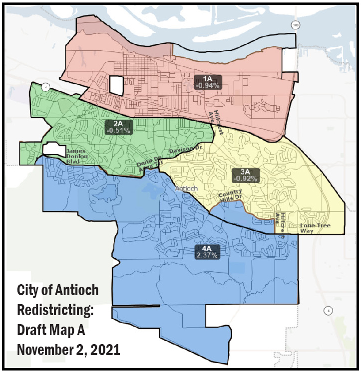
Antioch City Council Redistricting Map A supported by three members at Feb. 8, 2022, meeting. Current Antioch City Council boundaries are shown in black on this map. Proposed boundaries are shown in brown and filled in with color. Draft Map A only modifies the boundary between District 3 and 4.
Final map “shall” not divide “neighborhoods and ‘communities of interest’” by state law; two new maps comply with requirement
By Allen D. Payton
After narrowing down the choices to redistricting Maps B and 91 before their last meeting on Tuesday, Feb. 8, and hearing from the overwhelming majority of speakers in favor of Map 91 during that meeting, the Antioch City Council majority chose to reject both and return to Map A which had been previously rejected by four of the five council members, as their final choice. Antioch-Redistricting-Draft-Map-A
However, for their special meeting study session, tonight, Tuesday, Feb. 22 beginning at 6:00 p.m., the council will consider three more maps drawn and submitted by the public since the last council meeting. Those maps end with the numbers 512, 516 and 521. All the previous maps are also included in the agenda item. Antioch Council Redistricting Maps 512, 516, 521
FAIR MAPS Act Requires Undivided Neighborhoods
According to the staff report for the special meeting by City Attorney Thomas Lloyd Smith, “Under the (California) FAIR MAPS Act, the City Council shall draw and adopt boundaries using the following criteria in the listed order of priority (Elections Code 21621(c)):
- Comply with the federal requirements of equal population and the Voting Rights Act
- Be geographically contiguous
- Undivided neighborhoods and “communities of interest” (socio-economic geographic areas that should be kept together)
- Display easily identifiable boundaries
- Be compact (do not bypass one group of people to get to a more distant group of people)
- Shall not favor or discriminate against a political party”
The California FAIR MAPS Act was passed in 2019 and took effect Jan. 1, 2020, after the current council district map was adopted in 2018.
Council Majority’s Map Choice Violates Requirement, New Maps Don’t
Both Maps A and B, supported by District 1 Councilwoman Tamisha Torres-Walker, District 4 Councilwoman Monica Wilson and Mayor Lamar Thorpe divide neighborhoods and communities of interest, specifically homes in the same homeowners’ association. So, does new Map 512.
But Map 91 which is supported by Mayor Pro Tem and District 2 Councilman Mike Barbanica and District 3 Councilwoman Lori Ogorchock does not. Neither do new Maps 516 and 521, which are almost identical, except for a small section of land along Highway 4 west of Somersville Road and Auto Center Drive where no one lives.
However, Map 91 would result in Wilson living in District 3. While the location of an incumbent’s residence is not a criteria and is a political consideration, all the other maps leave the current council members in their current districts.
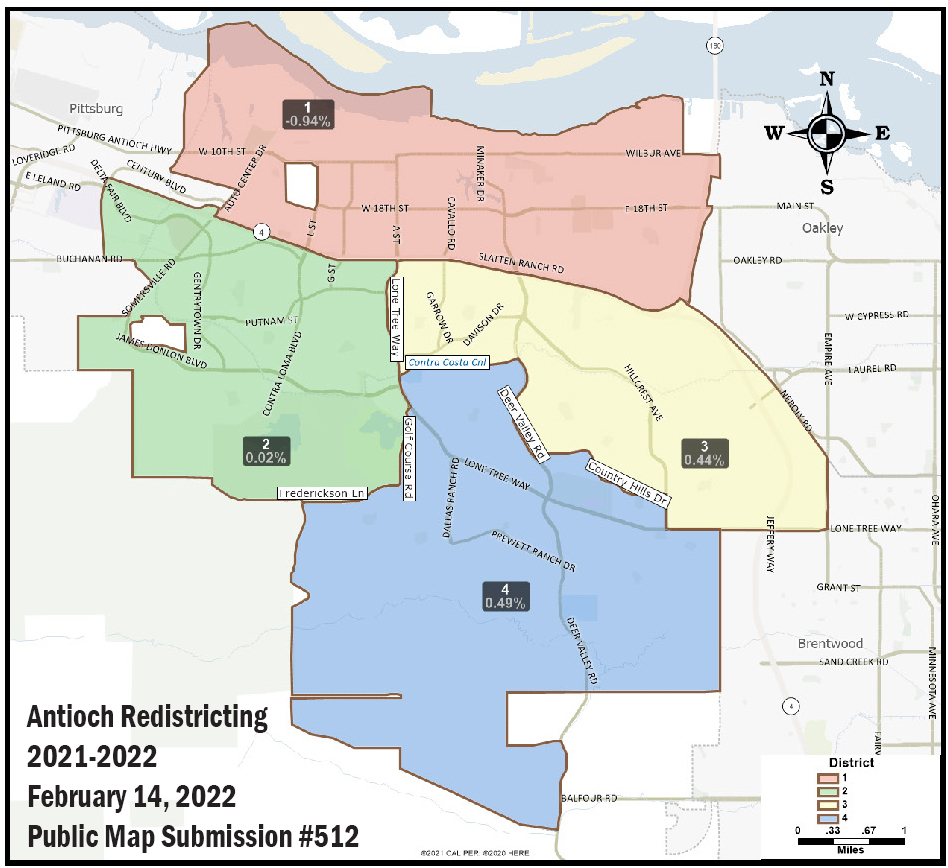
Redistricting Map 512
New Map 512
The comments made by the resident who drew and submitted Map 512, describing the boundaries for the four council districts, read, “Hopefully, this map will make everyone happy! It uses common sense boundary lines between districts. It uses Lone Tree Way as the boundary between Districts 2 and 3, and Districts 2 and 4. It uses the Delta DeAnza Trail/Contra Costa Canal between Lone Tree Way and Deer Valley Road as a boundary between Districts 3 and 4. It combines the Mira Vista Hills and all neighborhoods on both sides of James Donlon Blvd in District 2. It uses Deer Valley Road then Country Hills Drive between Deer Valley Road and Hillcrest Avenue, then Hillcrest Ave and Lone Tree Way as the boundary between Districts 3 and 4. The greatest population deviation between districts is 1.43% (between Districts 1 and 4). It’s clear to each resident in which district they live, and it doesn’t gerrymander to protect incumbents.”
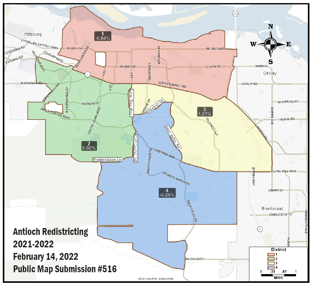
Redistricting Map 516
New Map 516
According to the description for Map 516, “This map keeps all neighborhoods together while using common sense boundary lines. The boundary line between Districts 2 and 3 is Lone Tree Way. The boundary between Districts 2 and 4 is Lone Tree Way and Golf Course Road. The boundary between Districts 3 and 4 is Davison Drive, Deer Valley Road and Lone Tree Way. The greatest population deviation between districts is 2.15% (Districts 1 and 3).”
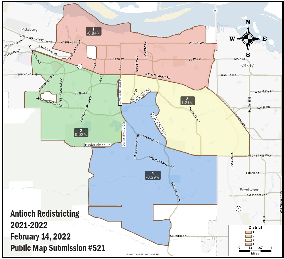
Redistricting Map 521
New Map 521
The resident who drew and submitted Map 521 wrote, “As no consensus could be reached and Map A is really no better than B, I tried to take the elements of both B & 91 that people seemed to like and combine for a new map.”
Districts in Place for Next 10 Years
How the district boundaries are drawn will determine who can run and be elected to the four council seats between 2022 and 2032.
Viewing Meeting & Public Comments
City Council meetings are televised live on Comcast channel 24, AT&T U-verse channel 99, or live stream at City Council Meeting LIVE – City of Antioch, California (antiochca.gov).
The public has the opportunity to address the City Council on each agenda item. No one may speak more than once on an agenda item or during “Public Comments”.
Members of the public wishing to provide public comments, may do so in one of the following ways (#2 pertains to the Zoom Webinar Platform):
- IN PERSON Fill out a Speaker Request Form, available near the entrance doors, and place in the Speaker Card Tray near the City Clerk before the City Council Meeting begins.
- VIRTUAL To provide oral public comments during the meeting, please click the following link to register in advance to access the meeting via Zoom Webinar: https://www.antiochca.gov/speakers
You will be asked to enter an email address and a name. Your email address will not be disclosed to the public. After registering, you will receive an email with instructions on how to connect to the meeting.
When the Mayor announces public comments, click the “raise hand” feature in Zoom. For instructions on using the “raise hand” feature in Zoom, visit: https://www.antiochca.gov/raise_hand. When calling into the meeting using the Zoom Webinar telephone number, press *9 on your telephone keypad to raise
your hand. Please ensure your Zoom client is updated so staff can enable your microphone when it is your turn to speak.
Speakers will be notified shortly before they are called to speak. When you are called to speak, please limit your comments to the time allotted (350 words, up to 3 minutes, at the discretion of the Mayor).
The City cannot guarantee that its network and/or the site will be uninterrupted.
- WRITTEN PUBLIC COMMENT If you wish to provide a written public comment, you may do so in one of the following ways by 3:00 p.m. the day of the City Council Meeting:
(1) Fill out an online speaker card, located at https://www.antiochca.gov/speaker_card,
Or (2) Email the City Clerk’s Department at cityclerk@ci.antioch.ca.us.
Please note: Written public comments received by 3:00 p.m. the day of the City Council Meeting will be shared with the City Council before the meeting, entered into the public record, retained on file by the City Clerk s Office, and available to the public upon request. Written public comments will not be read during the City Council Meeting.
the attachments to this post:
Antioch-Redistricting-Draft-Map-A
Antioch-Redistricting-Draft-Map-A

ACC Redistricting Map A

ACC Redistricting Map 521

ACC Redistricting Map 516

ACC Redistricting Map 512

Antioch Council Redistricting Maps 512, 516, 521