


Two more days to offer input on California Citizens Redistricting Commission’s final maps for state districts
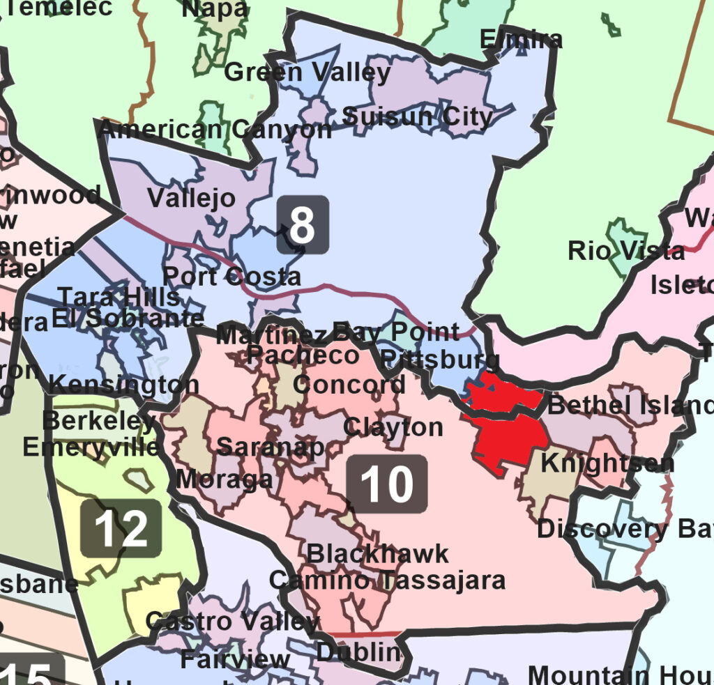
The commission’s final map shows Antioch (in red) divided into Congressional Districts 8 and 10. Source: WeDrawTheLinesCA.org
Antioch still split into two congressional districts; shares State Senate district with San Leandro; shares State Assembly district with Concord and Crockett
Divides Contra Costa County in multiple ways, combining portions with communities in other counties as far away as Sonoma and Yolo Counties over 90 miles away
By Allen Payton
On Monday, the 2020 California Citizens Redistricting Commission completed and approved final maps for the state’s Congressional, Senate, Assembly, and Board of Equalization districts that are significantly different than the draft maps presented last month. The new maps, which will be in place and affect elections for the next 10 years, split up Contra Costa County in multiple ways and combine portions with other counties and communities as much as 93 miles away.
The California Constitution states that public comment shall be taken for at least three days from the date of public display of any final statewide maps. Additionally, the Commission shall not display any other map for public comment during that period. (To offer additional public comment click here)
“We have reached the finish line for the people’s redistricting process in California. When voters approved the Voters FIRST Act, it created a monumental shift in this decennial process,” stated Commission Chair Alicia Fernandez. “As Californians, my colleagues on this Commission and I answered the call to serve for this great state we honor and love. We conclude our map drawing responsibilities with pride in our final product. We started this process leaving politics out of the equation in hopes of achieving fairer and more equitable maps. I think I speak for my colleagues when I say mission accomplished! Thank you to all that participated in this process.”
The Commission drew 4 Board of Equalization districts, 52 Congressional districts, 40 Senatorial districts, and 80 Assembly districts. All districts were drawn within the permissible population deviation.
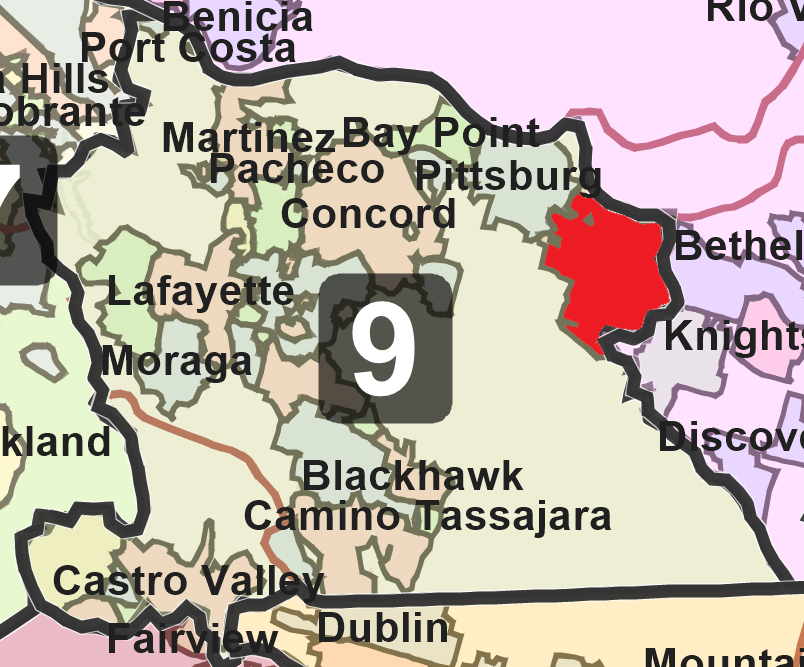
The commission’s final map shows all of Antioch (in red) in State Senate Districts 9. Source: WeDrawTheLinesCA.org
Maps Split Up Contra Costa County More
While the current maps approved in 2011 divide the county amongst four Congressional, two State Senate and three State Assembly districts, what the Commission did to Contra Costa, this time, was split it up even more into three Congressional, three State Senate, and four Assembly districts.
For the State Senate map, the majority of the county, from Crockett in West County to Antioch in East County is combined with San Leandro, Castro Valley and San Lorenzo in southwest Alameda County. Like the draft maps issued by the Commission in November, the new Senate map includes the Far East County cities of Brentwood and Oakley and communities of Discovery Bay, Byron, Bethel Island and Knightsen in the same district as Vallejo, Napa, Rohnert Park in Sonoma County, over 90 miles away. In addition, the map combines all of West County with the cities of Berkeley, Oakland and Alameda.
For the State Assembly map, the Commission keeps the county split in four districts keeping Far East County except for Brentwood, in the same district as most of Solano County including Vallejo, Fairfield, Vacaville and Dixon. It keeps most of West County in the same district, except for Crockett, which is included in the same district as Martinez, Pleasant Hill, Concord, Clayton, Bay Point, Pittsburg, Antioch and Brentwood.
The commission, only split the county amongst three districts for the Congressional map. But it splits up East County into those three, new separate districts by carving out Discovery Bay and Byron and leaving them in the same district as most of San Joaquin County. The proposed final map also combines the southern portion of Antioch, plus Brentwood, Oakley, Bethel Island and Knightsen with Central County, including most of Concord, plus Lamorinda, the San Ramon Valley and a portion of Dublin in the same congressional district. Finally, it splits off the northern portion of Antioch, plus Pittsburg and Bay Point, and includes it in a district with the other part of Concord, plus Martinez, West County cities of Richmond, El Cerrito, San Pablo, Pinole, Hercules and Crockett with most of Solano County.
Independent Commission Creates Maps That Benefit Democrats
The place of residence of any incumbent or political candidate may not be considered in the creation of a map, and districts may not be drawn for the purpose of favoring or discriminating against an incumbent, political candidate, or political party.
However, according to a news report by the left-leaning Politico, “California’s new congressional map boosts Democrats” in their “uphill quest to maintain their minuscule House majority”. The new lines “create more challenging districts for Republican incumbents without substantially undermining the prospects of vulnerable Democrats.” The “map could point to Democrats holding ground or picking up seats.”
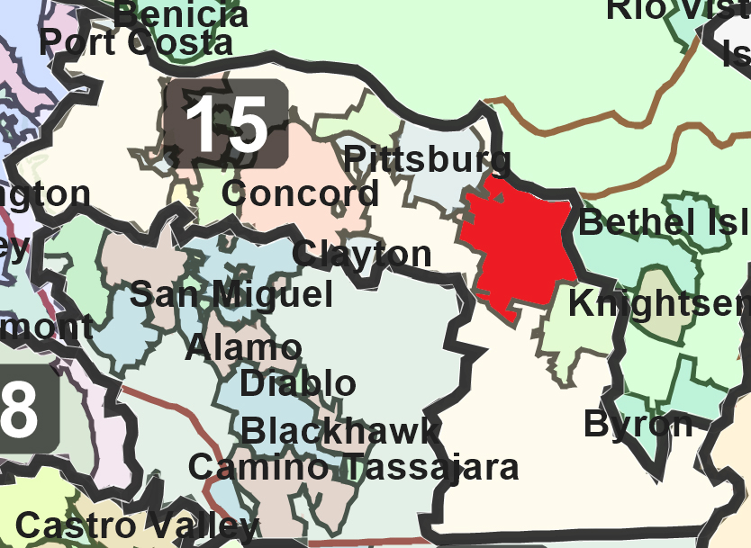
The commission’s final map shows all of Antioch (in red) in Assembly Senate Districts 15. Source: WeDrawTheLinesCA.org
See Shape Files/Equivalency Files/Stats and Map Viewer: https://www.wedrawthelinesca.org/final_maps
In accordance with the California Constitution, the Commission followed these criteria, in this order, to draw district maps:
- Districts must be of equal population to comply with the U.S. Constitution.
- Districts must comply with the Voting Rights Act to ensure that minorities have an equal opportunity to elect representatives of their choice.
- Districts must be drawn contiguously, so that all parts of the district are connected to each other.
- Districts must minimize the division of cities, counties, neighborhoods and communities of interest to the extent possible.
- Districts should be geographically compact: such that nearby areas of population are not bypassed for a more distant population. This requirement refers to density, not shape. Census blocks cannot be split.
- Where practicable each Senate District should be comprised of two complete and adjacent Assembly Districts, and Board of Equalization districts should be comprised of 10 complete and adjacent State Senate Districts.
The last of the criteria makes sense, as there are twice as many Assembly districts as Senatorial districts, and the Commission could have simply divided each Senatorial district into two. But they chose not to follow it when drawing the new maps.
Additional Commission Meetings
The Commission is continuing to hold meetings Sunday and next Monday and accepting additional public comments on the final maps. At the start of Tuesday’s meeting, Chair Fernandez announced that the meetings scheduled for tomorrow (Wednesday) and Thursday, as shown on the Commission’s website, have been cancelled.
December 26, 2021 CRC Business Meeting – 2020 Citizens Redistricting Commission Meeting – 11:00 A.M. – 1:00 P.M. daily or upon conclusion of business Public Input Form
December 27, 2021 CRC Business Meeting – 2020 Citizens Redistricting Commission Meeting – 11:00 A.M. – 1:00 P.M. daily or upon conclusion of business Public Input Form
Background on Redistricting and Commission
Every 10 years, after the federal government publishes updated census information, California must redraw the boundaries of its electoral districts so that the state’s population is evenly allocated among the new districts.
In 2008, California voters passed the Voters First Act, authorizing the creation of the independent California Citizens Redistricting Commission to draw new State Senate, State Assembly, and State Board of Equalization district lines. In 2010, the Voters First Act for Congress gave the Commission the responsibility of drawing new Congressional districts following every census.
For more information, please visit www.WeDrawTheLinesCA.org. To offer additional comments to the Commission about the proposed final maps visit www.wedrawthelinesca.org/contact by Thursday, Dec. 23 at 5:00 p.m.
the attachments to this post:

Antioch Final SD 9

Antioch Final CD’s 8&10

Antioch Final AD 15 Map