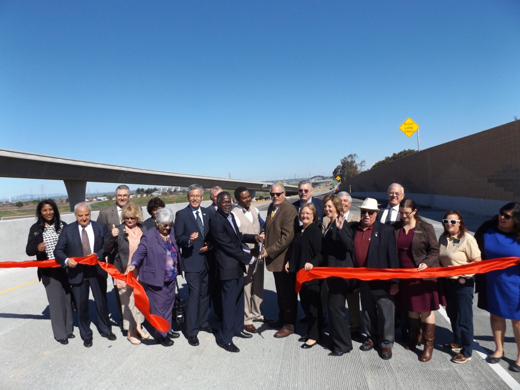
Officials celebrate after cutting the ribbon on the new Highway 4/160 northbound ramp on Monday, Feb. 29, 2016. photo by Allen Payton
Officials highlight improved regional mobility, waterfront access and congestion relief with Ribbon Cutting Ceremony, Monday
Antioch/Oakley, CA—The Contra Costa Transportation Authority (CCTA) and the Metropolitan Transportation Commission (MTC)/Bay Area Toll Authority (BATA), joined by state, regional, and local officials, marked the completion of work on the much-needed $50 million connection between State Route 160, the Senator John A. Nejedly Bridge (Antioch Bridge), and Highway 4 with a brief ribbon cutting ceremony Monday morning, February 29th.
“It will reduce greenhouse gases and congestion on local roads,” said CCTA Executive Director Randell Iwasaki.
The new ramps – one connecting westbound Highway 4 to northbound State Route 160, and one connecting southbound State Route 160 to eastbound Highway 4 – opened Monday afternoon and eliminate the U-turn that was previously required at Hillcrest Avenue, reduce through traffic and congestion on Oakley’s city streets, and improve access for Eastern Contra Costa County.
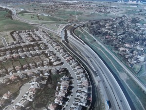
The new Highway 4/160 interchange ramps opened on Monday, Feb. 29 following a ribbon cutting ceremony. photo courtesy of CCTA
The completed State Route 160/Highway 4 Direct Connector Ramps add an additional 12-foot auxiliary lane to State Route 160 in both directions between the State Route 160/Highway 4 Interchange and the East 18th/Main Street Interchange. The new structure crosses the median of Highway 4 at a height that can accommodate a future BART extension.
“This makes the northern waterfront more viable for economic growth,” said Assemblyman Jim Frazier, who was part of the CCTA Board and an Oakley Councilman when the funding for the project was approved.
The project features sound wall extensions and new retaining walls in addition to the 2.62 new lane miles under construction, and was funded entirely by $50 million in Bay Area Toll Authority (BATA) Bridge Toll Funds.
“MTC/BATA is proud to support these important improvements, which enhance safety and mobility for the residents and motorists of Eastern Contra Costa County,” said Federal Glover, MTC/BATA Commissioner and Contra Costa County Supervisor.
The addition of the interchange connectors is part of a massive $1.3 billion undertaking by CCTA and project partners to widen the Highway 4 corridor between Pittsburg and Antioch in eastern Contra Costa County and extend BART to Antioch.
“This latest segment of the Highway 4 improvement projects is furthering our efforts to improve regional mobility, revitalize the local economy, and improve the quality of life for 250,000 residents in East County,” Iwasaki added. “These projects are possible in large part due to the passage of a local half-cent sales tax by Contra Costa voters in 2004.”
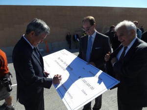
Randell Iwasaki, Executive Director of the CCTA signs a ceremonial check for the project’s leftover funds totaling $1 million, as Steve Heminger, Executive Director of the Metropolitan Transportation Commission and Bijan Sartipi, Region IV Director for CalTrans look on. photo by Allen Payton
The Highway 4 projects include improvements that will help modernize eastern Contra Costa County. The projects expand Highway 4 from four to eight lanes between Loveridge Road in Pittsburg to just west of State Route 160 in Antioch, from two to four lanes from Lone Tree Way to Sand Creek Road in Brentwood, add missing connector ramps at the State Route 160/Highway 4 interchange, and add a BART extension from Pittsburg to Antioch. This will greatly improve transit accessibility for the region, help reduce traffic congestion, and enhance the quality of life for the more than 250,000 residents of eastern Contra Costa County. The projects have been carefully staged to keep 130,000 vehicles per day moving as major construction and demolition work continue. These projects, plus previously constructed projects in the region, bring the total investment in East County to $1.3 billion, including State, Federal, Contra Costa Transportation Authority Measures C and J, regional bridge tolls, and other funds.
For additional information about Highway 4 Corridor Improvements/BART, please visit www.4eastcounty.org