Archive for the ‘Recreation’ Category

Overnight Highway 4 (bypass) closure this weekend May 5-6

Tuesday, May 2nd, 2023
Mokelumne Trail Overcrossing April 2023 progress. Photo: CCTA

Midnight to 6:00 am for Mokelumne Trail overcrossing

BRENTWOOD, CA – In partnership with the City of Brentwood, the Contra Costa Transportation Authority (CCTA) is constructing the Mokelumne Trail Bicycle and Pedestrian Overcrossing to provide safe access to cyclists and pedestrians for commuting and recreational travel, reconnecting two sides of the trail that were separated by the expansion of State Route 4.  The overnight closure will facilitate final adjustments to the falsework as part of the construction work installing the pedestrian and bicyclist crossing over State Route 4.  This closure will impact State Route 4 in both the Eastbound and Westbound directions.  CCTA and the California Department of Transportation (Caltrans) have scheduled the closure during the early morning hours in order to minimize impacts to the motoring public.

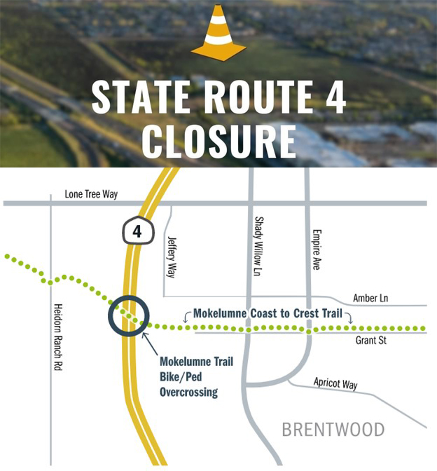
Overnight Freeway Closure of State Route 4 between Lone Tree Way and Sand Creek Road
In order to ensure crew and public safety during the planned construction work, a temporary nighttime freeway closure in both directions of State Route 4 will occur between Friday, May 5, 2023 and Saturday, May 6, 2023 on the following schedule (weather permitting):
Eastbound and Westbound Highway 4 will be closed from midnight on Friday, May 5 until 6:00am on Saturday, May 6, 2023. 

Detours
Detours will be in place to reroute drivers around the closure and are planned as follows:
Eastbound traffic will be directed to exit at Lone Tree Way, go eastbound to Shady Willow Lane, then southbound on Shady Willow Lane to Sand Creek Road, before proceeding westbound on Sand Creek Road to the eastbound State Route 4 on-ramp.

Westbound drivers having to detour will exit on Sand Creek Road and go eastbound on Sand Creek Road to Shady Willow Lane, then northbound on Shady Willow Lane to Lone Tree Way, and proceed westbound on Lone Tree Way to the westbound State Route 4 on-ramp.

Future Freeway Closures

Additional overnight closures will be needed over the course of the next eight weeks (weather dependent) to facilitate concrete pours for the stem and soffit and deck of the future Mokelumne Trail Bicycle and Pedestrian Overcrossing.  Additional information regarding dates and detours will be provided once the schedule is confirmed.  This project is anticipated to be complete in late summer or early fall of 2023.

About the Contra Costa Transportation Authority

The Contra Costa Transportation Authority (CCTA) is a public agency formed by Contra Costa voters in 1988 to manage the county’s transportation sales tax program and oversee countywide transportation planning efforts. With a staff of twenty people managing a multi-billion-dollar suite of projects and programs, CCTA is responsible for planning, funding and delivering critical transportation infrastructure projects and programs that connect our communities, foster a strong economy, increase sustainability, and safely and efficiently get people where they need to go. CCTA also serves as the county’s designated Congestion Management Agency, responsible for putting programs in place to keep traffic levels manageable. More information about CCTA is available at ccta.net.

Celebrate Easter at Solar Swim & Gym Saturday, April 1

Thursday, March 30th, 2023

Learn to dance with The Hip Hop Experience class in Antioch

Friday, March 24th, 2023

Explore the fundamentals of hip hop and creative movement as you experience the different styles of popping & locking, tutting, funk and b-boying. Dancers will learn technical movements, the basis of improvisation, and a collaborative routine. Wear workout/dance attire to each class.

Antioch Recreation Dept hiring summer staff

Thursday, March 23rd, 2023

Highway 4 lanes in Brentwood to be closed for completion of trail overcrossing March 24-29

Thursday, March 23rd, 2023

One-direction at a time, late night, early morning except Saturday night

Caltrans is scheduled to install the Mokelumne Trail Bicycle and Pedestrian Overcrossing span over State Route 4 (“SR4”) in Brentwood beginning Friday night, March 24 through early Wednesday morning, March 29, 2023. Expect State Route 4 closures between Sand Creek Road and Lone Tree Way.

Weather permitting, Caltrans will be closing the highway one-direction at a time as described below:

March 24th:  Eastbound SR4 closure from midnight Friday until 6:00 a.m. Saturday.

March 25th:  No closure on Saturday night.

March 26th:  Westbound SR4 closure on Sunday from 1:00 a.m. to 7:00 a.m.

March 26th-27th:  Westbound SR4 closure on Sunday from 11:00 p.m. until 4:00 a.m. Monday.

March 27th:  Eastbound SR4 closure on Monday from 11:00 p.m. until 4:00 a.m. Tuesday.

March 28th:  Eastbound or westbound SR4 closure on Tuesday from 11:00 p.m. until 4:00 a.m. Wednesday, if needed to complete any remaining work.

Detour Route:

Westbound traffic will exit Sand Creek Road and proceed eastbound on Sand Creek Road to Shady Willow Lane, proceed northbound on Shady Willow Lane to Lone Tree Way, and proceed westbound on Lone Tree Way to the westbound SR4 on-ramp.

Eastbound traffic will exit Lone Tree Way, proceed eastbound on Lone Tree Way to Shady Willow Lane, proceed southbound on Shady Willow Lane to Sand Creek Road, and proceed westbound on Sand Creek Road to the eastbound SR4 on-ramp.

Funding for the $13 million project is provided through Measure J taxpayer dollars from the county’s half-cent sales tax for transportation, the State Route 4 Bypass Authority, and bridge toll funds. The overcrossing is expected to be completed early this year.

For updates and detailed information, please visit https://brentwood.info/SR4_Closure. To learn more about the project visit Mokelumne Trail Bicycle/Pedestrian Overcrossing.

Allen D. Payton contributed to this report.

7th Annual Antioch Rotary Club Bunny Hop 5K run Saturday, April 8

Saturday, March 11th, 2023

Save Mount Diablo unveils long-desired 1.25-mile Knobcone Point Trail connection

Friday, March 10th, 2023

Hikers on the trail near Cave Point and Riggs Canyon. Photo: Scott Hein

To open March 29 from Balancing Rock to Riggs Canyon on Mount Diablo

By Laura Kindsvater, Communications Manager, Save Mount Diablo 

On March 29, Save Mount Diablo will officially open the Knobcone Point to Riggs Canyon trail connection. This section of trail winds through the upper 560 acres of Mount Diablo’s Curry Canyon Ranch, through one of Mount Diablo’s wildest areas. It travels from Balancing Rock and Knobcone Point, to Cave Point, to Windy Point and Riggs Canyon.

Although the trail was once available to the public ranging all over the mountain before proliferation of cattle fencing, it’s been nearly a hundred years since it was legal.

The 1.25-mile-long trail will considerably expand the amount of open space available to explore on Mount Diablo’s southern hills. It will effectively fully connect Rock City and Mount Diablo to Riggs Canyon, Morgan Territory, and Los Vaqueros via publicly accessible trails.

Curry Canyon is the final missing major canyon entrance to Mount Diablo. Curry Canyon Ranch has over nine miles of fire roads, most of which will continue to be closed for now, while Save Mount Diablo works with California State Parks to transfer much of the property to the park.

Map showing the new trail segment. Map by Roxana Lucero, Save Mount Diablo

Currently Mount Diablo State Park visitors must climb in and out of four canyons from Rock City to Riggs Canyon—going forward, they can follow a ridgeline with spectacular views.

Right now, state park staff must leave the state park to reach Riggs Canyon. Opening the ridgeline fire road on Save Mount Diablo’s property will solve this access and management issue.

In preparation for the grand opening, Save Mount Diablo’s staff and volunteers have been installing infrastructure, including access gates and informational signage.

They have also been removing dead material to minimize fire risk in the area. The removal of dead and scorched plants in this area will encourage new growth of native and endemic wildflowers and chaparral plants this spring.

This project has been a decade in the making, in the works since Save Mount Diablo acquired the 1,080-acre Curry Canyon Ranch property in 2013.

Rocky cliffs in the Knobcone Point area of Save Mount Diablo’s Curry Canyon Ranch. Photo: Scott Hein

“Thanks to our terrific supporters, staff, partners, and volunteers, like our Trail Dogs, Save Mount Diablo has created and opened a number of public trails the last two years. Last year, we created and opened over four miles of trails at our new Mangini Ranch Educational Preserve. This year, we will finish and open an important 1.25 +/- mile trail on Save Mount Diablo’s Curry Canyon Ranch that will allow the public to hike from Knobcone Point at Mount Diablo State Park, through the upper portions of our spectacular Curry Canyon Ranch, to Riggs Canyon at the state park. All these trails we have built are portals that allow the public to enter nature and be transformed for the better,” said Ted Clement, Save Mount Diablo Executive Director.

As part of its goal of getting more people into nature, Save Mount Diablo has been opening more land to the public and creating new trails over the years. In 2022, Save Mount Diablo opened several miles of trails at its Mangini Ranch Educational Preserve in Concord for people to enjoy.

Now the highly anticipated Knobcone Point trail connection will further open up opportunities to enjoy Mount Diablo’s majestic views and wilderness—recreationalists will experience a rarely seen part of the mountain.

Vicinity map showing the new trail segment highlighted in orange. Map by Save Mount Diablo

“This trail is the major recreational puzzle piece in the Mount Diablo area, allowing park users to connect the mountain to Morgan Territory and beyond to Los Vaqueros, furthering their adventure into this extraordinary place,” said Sean Burke, Save Mount Diablo Land Programs Director.

Traveling along this newly opened trail, visitors will be immersed in the knobcone pine forests after which the area is named and stunning sandstone rock formations. They may see golden eagles and songbirds fly overhead.

This trail will open up a rarely traveled area; it will give hikers an opportunity to explore and experience the solitude of one of the extraordinary parts of Mount Diablo.

A trail opening ceremony will take place on the property at the Knobcone Point gate near Balancing Rock at 11:00 AM on March 29, weather permitting. We invite the public to hike in and join us. If you’d like to come, meet at Curry Point in Mount Diablo State Park on South Gate Road at 9:30 AM. There is a park entrance fee of $10, and parking at Curry Point is limited. The hike from Curry Point to the ceremony is a little over two miles.

The Knobcone Point Road trail segment travels along the ridgeline from Knobcone Point to Riggs Canyon. Photo: Scott Hein

After the ceremony, staff will lead a hike to the Riggs Canyon gate. The hike from the Knobcone Point gate to the Riggs Canyon gate is 1.25 miles.

In the event of heavy rain, the trail will still be opened to the public on March 29, but we will cancel the trail opening ceremony.

It is with great pride and excitement that Save Mount Diablo will open this trail connection and share the beauty of Knobcone Point, Cave Point, and Riggs Canyon with all who visit.

About Save Mount Diablo

Save Mount Diablo is a nationally accredited, nonprofit land trust founded in 1971 with a mission to preserve Mount Diablo’s peaks, surrounding foothills, watersheds, and connection to the Diablo Range through land acquisition and preservation strategies designed to protect the mountain’s natural beauty, biological diversity, and historic and agricultural heritage; enhance our area’s quality of life; and provide educational and recreational opportunities consistent with protection of natural resources. To learn more, please visit www.savemountdiablo.org.

East Bay Park District seeking lifeguards for 2023 swim season

Tuesday, March 7th, 2023

Photo source: EBRPD

The East Bay Regional Park District is looking to hire over 50 new lifeguards for the 2023 swim season at its 12 East Bay swim facilities, which include lakes, lagoons, and swimming pools. All new lifeguard positions are seasonal, full-time positions from May through September. Anyone ages 16 and over before April 22, 2023, are encouraged to apply. Starting pay is $20.78 per hour. Applications will be accepted through March 27, 2023.

There are six lifeguard testing dates scheduled in March. Participants will be asked to swim 550 yards in under 10 minutes, carry a rescue board 50 feet, retrieve three dive rings under four to seven feet of water, tread water for two minutes using only their legs, and retrieve a 10-pound brick from underwater. There will also be a short informal interview after successful completion of the swim test on the same day.

Testing Schedule:

•    Saturday, March 11, at Buchanan Pool, Pittsburg

•    Sunday, March 12, at Granada High School Pool, Livermore

•    Saturday, March 18, at San Leandro High School Pool, San Leandro

•    Sunday, March 19, at Granada High School Pool, Livermore

•    Saturday, March 25, at Buchanan Pool, Pittsburg

•    Sunday, March 26, at Castro Valley High School Pool, Castro Valley

Participants who pass the tests will be invited to the Park District’s Lifeguard Academy beginning Saturday April 22, 2023, where they will receive paid training and certification in open water lifeguarding. The Lifeguard Academy takes place over five consecutive weekends in April and May, with the swim season beginning in late May for most facilities.

“Working as a lifeguard is one of the few ways a young adult can give back to their community and learn about public service,” said East Bay Regional Park District Aquatics Manager Pete DeQuincy. “Promoting water safety and educating park visitors on how to safely recreate in, on, and around water is paramount in what a lifeguard does.”

Lifeguards can work at any of the Park District’s swim facilities in various cities in Alameda and Contra Costa counties, such as Antioch, Concord, Livermore, Hayward, Castro Valley, Oakland, Alameda, and Berkeley.

For information and how to apply, visit www.ebparks.org/public-safety/lifeguard/jobs.

The East Bay Regional Park District is the largest regional park system in the nation, comprising 73 parks, 55 miles of shoreline, and over 1,300 miles of trails for hiking, biking, horseback riding, and environmental education. The Park District receives more than 25 million visits annually throughout Alameda and Contra Costa counties in the San Francisco Bay Area.