In partnership with Bay Area Backyard Movement, the City of Antioch Recreation Department is excited to present our second Multicultural Day Festival! Highlighting cultural diversity and community engagement, this event features live performances, local vendors, a kid’s zone and much more for all to enjoy. You won’t want to miss this!
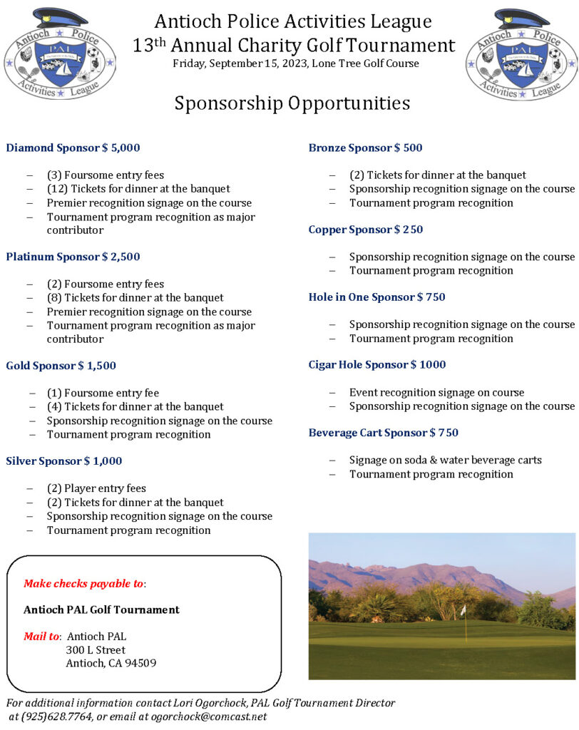
It’s that time of the year again! We are proud to announce the 13th Annual Antioch Police Activities League Charity Golf Tournament is open for player and sponsorship registration. Don’t miss your chance to be part of this year’s fun and excitement! The tournament will take place on Friday, September 15th 2023, at the beautiful Lone Tree Golf and Event Center at 4800 Golf Course Road here in Antioch.
Attached you will find the registration form with additional information about how to register players, sponsor the event, or both! As in prior years, we are limiting our field to 128 players. Don’t wait too long to register, as you may miss out on participating in THE premier tournament in East County!
Please remember, all proceeds raised from this tournament go toward helping the youth in our community stay active and socially involved through positive relationships with mentors and members of the Antioch Police Department. We are a non-profit 501(c)(3) organization, and your donation/sponsorship can be considered tax deductible.
If you have any questions, please do not hesitate to contact me.
***Many of you who have played in prior PAL tournaments know it always sells out. As in years past, teams that register as part of a sponsorship get priority entry. Standard entries are then taken on a first come first serve basis. Any extra entries are placed on a waiting list and will be kept informed of openings in case any teams back out prior to the tournament.
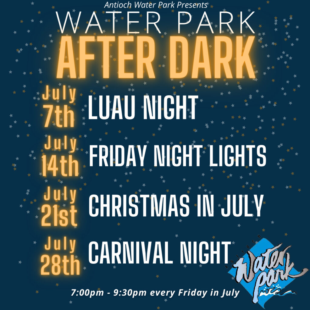
All events at the Antioch Water Park at Prewett Family Park, 4701 Lone Tree Way, include night swim! Tickets and passes available at antiochwaterpark.com
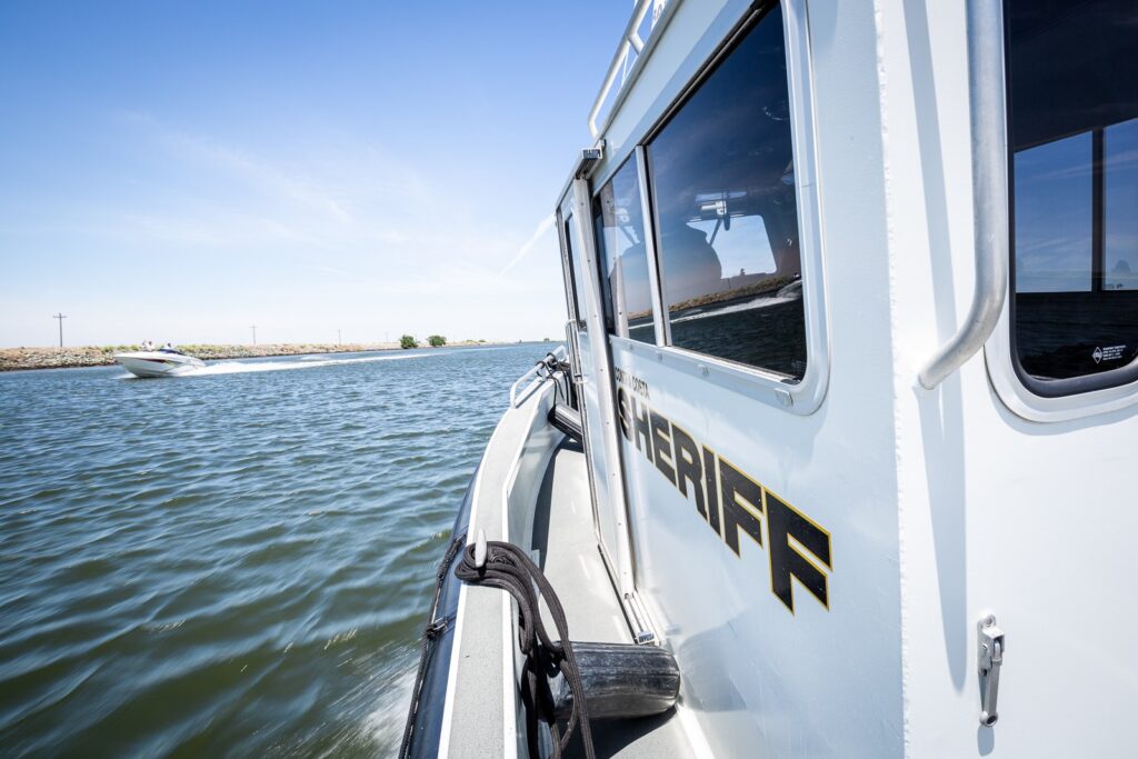
The Memorial Day holiday weekend traditionally marks the start of boating season on the Delta. A large number of people are expected to be on the water this weekend and throughout the summer to go fishing, boating or take part in water sports, like water-skiing.
“We want all boaters and those on the Delta to enjoy themselves, but to be safe,” said Contra Costa Sheriff David Livingston. “By following the laws and regulations, wearing a life-jacket, avoiding alcohol, and boating safely, you could help avoid an accident or tragedy on the water.”
The Contra Costa County Office of the Sheriff Marine Ser-vices Unit would like to remind all boaters to be safe, alert, and obey the rules. Here are some important rules and tips:
-Anyone 50 or under who oper-ates a vessel that is propelled by an engine, regardless of whether the engine is the principal source of propulsion, must have in their possession a California Boater Card issued by the state. By 2025, anyone operating a motorized vessel will be required to possess a California Boater Card. For more information on the California Boater Card, go to www.dbw.ca.gov.
-All vessels, including stand-up paddle boards (SUPs), must have a U.S. Coast Guard approved life jacket for each person. The life jacket must fit the person intending to wear it. Children under 13 must always wear a life jacket while aboard any vessel, regardless of length, unless they are surrounded by an enclosed cabin or bulkhead. We encourage every-one, regardless of age, to wear a personal floatation device at all times when on the water.
-You must be at least 16 years old to operate a power boat or personal watercraft. All persons on a personal watercraft are required to wear an approved life jacket.
-Boats 16 feet and larger are required to have a life ring or square type 4 throwable flotation device which must be immediately accessible.
-Always travel at a safe speed. Slow down in narrow channels and blind areas and navigate on the right side of the waterway. In crossing situations, the boat on the right has the right of way.
-The operator of a vessel involved in towing a skier must display, or cause to be displayed, a red or orange water ski flag to indicate: a downed skier, a skier in the water preparing to ski, a ski line extended for the vessel, or a ski in the water in the vicinity of the vessel.
-Blue Light law — Any vessel approaching, overtaking, being approached, or being overtaken by a moving law enforcement or emergency vessel operating with a siren or an illuminated blue light, or any vessel approaching a stationary law enforcement vessel displaying an illumi-nated blue light, shall immediately slow to a speed sufficient to maintain steerage. Boaters cannot make a wake near a law enforcement vessel displaying a blue light.
-Always have an emergency kit that includes a flashlight, warm clothing, cell phone, VHF radio and chart. For emergencies on the water, boaters should call 911 or Sheriff’s Dispatch at (925) 646-2441. Be sure to file a float plan before you depart. Go to this link for more information on float plans and how to fill one out:
-Be aware of potential carbon monoxide poisoning that can occur when the motor is running while occupying the swim platform or in vicinity of the vessel’s transom.
Boating under the influence (B.U.I.) enforcement is a high priority. Those arrested for B.U.I. will face similar consequences as those who drive a motor vehicle under the influence, including fines and possible jail time.
The ‘ABC’s of Boating’, a handbook of boating rules, is available from most boating shops. Boaters can go to the California Division of Boating and Waterways website at www.dbw.ca.gov for information on boating safety and the California Boater Card. If anyone has any questions about boating safety, please contact the Marine Services Unit at (925) 427-8507.
Mokelumne Trail Overcrossing April 2023 progress. Photo: CCTA
For Mokelumne Trail Bicycle and Pedestrian Overcrossing
By Linsey Willis, Director of External Affairs, CCTA
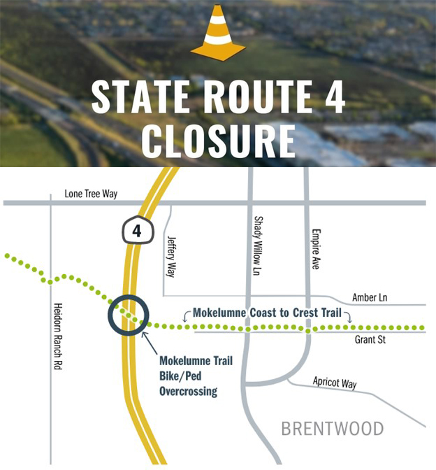
BRENTWOOD, CA – In partnership with the City of Brentwood, the Contra Costa Transportation Authority (CCTA) is constructing the Mokelumne Trail Bicycle and Pedestrian Overcrossing to provide safe access to cyclists and pedestrians for commuting and recreational travel, reconnecting two sides of the trail that were separated by the expansion of State Route 4. The overnight closure will enable the contractor to pour concrete for the superstructure as part of the construction work installing the pedestrian and bicyclist crossing over State Route 4. This closure will impact State Route 4 in both the Eastbound and Westbound directions. CCTA and the California Department of Transportation (Caltrans) have scheduled the closure during the early morning hours in order to minimize impacts to the motoring public.
Overnight Freeway Closure of State Route 4 between Lone Tree Way and Sand Creek Road
In order to ensure crew and public safety during the planned construction work, a temporary nighttime freeway closure in both directions of State Route 4 will occur between Friday, May 19, 2023 and Saturday, May 20, 2023 on the following schedule (weather permitting): Eastbound and Westbound Highway 4 will be closed from 9:00pm on Friday, May 19 until 6:00am on Saturday, May 20, 2023.
Detours
Detours will be in place to reroute drivers around the closure and are planned as follows:
Eastbound traffic will be directed to exit at Lone Tree Way, go eastbound to Shady Willow Lane, then southbound on Shady Willow Lane to Sand Creek Road, before proceeding westbound on Sand Creek Road to the eastbound State Route 4 on-ramp.
Westbound drivers having to detour will exit on Sand Creek Road and go eastbound on Sand Creek Road to Shady Willow Lane, then northbound on Shady Willow Lane to Lone Tree Way, and proceed westbound on Lone Tree Way to the westbound State Route 4 on-ramp.
Future Freeway Closures
Additional overnight closures will be needed over the course of the next eight weeks (weather dependent) to facilitate concrete pours for the stem and soffit and deck of the future Mokelumne Trail Bicycle and Pedestrian Overcrossing. Additional information regarding dates and detours will be provided once the schedule is confirmed. This project is anticipated to be complete in late summer or early fall of 2023.
About the Mokelumne Trail Bicycle and Pedestrian Overcrossing
In partnership with the City of Brentwood, the Contra Costa Transportation Authority (CCTA) is constructing the Mokelumne Trail Bicycle and Pedestrian Overcrossing to provide safe access to cyclists and pedestrians for commuting and recreational travel, reconnecting two sides of the trail that were separated by the expansion of State Route 4.
When completed, the overcrossing will provide access to the future East County Intermodal Transit Center and BART Station in Brentwood, as well. It is part of the larger Mokelumne Coast to Crest Trail which also includes the Delta de Anza Regional Trail that runs through Antioch and Oakley, that will, when completed, connect six counties across California from the East Bay to the Sierra Nevada Mountains.
The cost to design and build the bridge is approximately $13 million, with funding provided through Measure J taxpayer dollars, the State Route 4 Bypass Authority, and bridge toll funds.
About the Contra Costa Transportation Authority
The Contra Costa Transportation Authority (CCTA) is a public agency formed by Contra Costa voters in 1988 to manage the county’s transportation sales tax program and oversee countywide transportation planning efforts. With a staff of twenty people managing a multi-billion-dollar suite of projects and programs, CCTA is responsible for planning, funding and delivering critical transportation infrastructure projects and programs that connect our communities, foster a strong economy, increase sustainability, and safely and efficiently get people where they need to go. CCTA also serves as the county’s designated Congestion Management Agency, responsible for putting programs in place to keep traffic levels manageable. More information about CCTA is available at ccta.net.
The new floor at Paradise Skate Roller Rink is ready for skaters. Source: Paradise Skate
First session this Friday, May 12 at 5 p.m.
Following repairs to damage to the floor of the Paradise Skate caused by flooding during the winter storms, East County’s only roller rink will reopen this Friday, May 12.
STEM Director Robert Bruce said, “there have been a lot of people that have helped out. Our Artistic, Derby and Speed Club members stepped up and helped with our construction.”
A post on their Facebook page on Sunday reads: This is the announcement everyone has been waiting for.
We will be opening this coming Friday at 5 pm for our first session.
Friday May 12 – 5 pm to 7 pm, 8 pm to 10 pm
Saturday May 13 – Noon to 2 pm 3 pm to 5 pm, 9 pm to 11 pm
Sunday May 14 – Noon to 2 pm, 3 pm to 5 pm
The following week the Contra Costa County Fair is here.
Entrance to our Roller Rink is through the main fairgrounds.
Separate fee to enter the fair.
Our Artistic Club will be performing on Thursday May 18th at 6 pm and Saturday May 20th at 2 pm FREE to watch.
Our Derby Club will be performing on Friday May 19th at 6 pm and Saturday May 20th at 6 pm
Hours are noon to 9 pm Thursday, Friday, Saturday and Sunday
Separate fee to skate.
See you then.
Paradise Skate is located inside the Contra Costa Event Park at 1201 W. 10th Street in Antioch. For more information call (925) 779-0200 or visit www.paradiseskate.com.
The overnight closure of State Route 4 between Lone Tree Way and Sand Creek Road in Brentwood originally planned for Friday, May 5 through Saturday, May 6, 2023 has been postponed one week to Friday, May 12 through Saturday, May 13, 2023.
In partnership with the City of Brentwood, the Contra Costa Transportation Authority (CCTA) is constructing the Mokelumne Trail Bicycle and Pedestrian Overcrossing to provide safe access to cyclists and pedestrians for commuting and recreational travel, reconnecting two sides of the trail that were separated by the expansion of State Route 4.
When completed, the overcrossing will provide access to the future East County Intermodal Transit Center and BART Station in Brentwood, as well. It is part of the larger Mokelumne Coast to Crest Trail which also includes the Delta de Anza Regional Trail that runs through Antioch and Oakley, that will, when completed, connect six counties across California from the East Bay to the Sierra Nevada Mountains.
The overnight closure will facilitate final adjustments to the falsework as part of the construction work installing the pedestrian and bicyclist crossing over State Route 4. This closure will impact State Route 4 in both the Eastbound and Westbound directions. CCTA and the California Department of Transportation (Caltrans) have scheduled the closure during the early morning hours in order to minimize impacts to the motoring public.
In order to ensure crew and public safety during the planned construction work, a temporary nighttime freeway closure in both directions of State Route 4 will occur in both Eastbound and Westbound lanes of Highway 4 from midnight on Friday, May 12 until 6:00am on Saturday, May 13, 2023 (weather permitting).
Detours Detours will be in place to reroute drivers around the closure and are planned as follows: Eastbound traffic will be directed to exit at Lone Tree Way, go eastbound to Shady Willow Lane, then southbound on Shady Willow Lane to Sand Creek Road, before proceeding westbound on Sand Creek Road to the eastbound State Route 4 on-ramp.
Westbound drivers having to detour will exit on Sand Creek Road and go eastbound on Sand Creek Road to Shady Willow Lane, then northbound on Shady Willow Lane to Lone Tree Way, and proceed westbound on Lone Tree Way to the westbound State Route 4 on-ramp.
Future Freeway Closures
Additional overnight closures will be needed over the course of the next eight weeks (weather dependent) to facilitate concrete pours for the stem and soffit and deck of the future Mokelumne Trail Bicycle and Pedestrian Overcrossing. Additional information regarding dates and detours will be provided once the schedule is confirmed. This project is anticipated to be complete in late summer or early fall of 2023.