Archive for the ‘Politics & Elections’ Category

Antioch Council districting workshop results in changed Quadrants map, gets heated at the end

Tuesday, April 10th, 2018

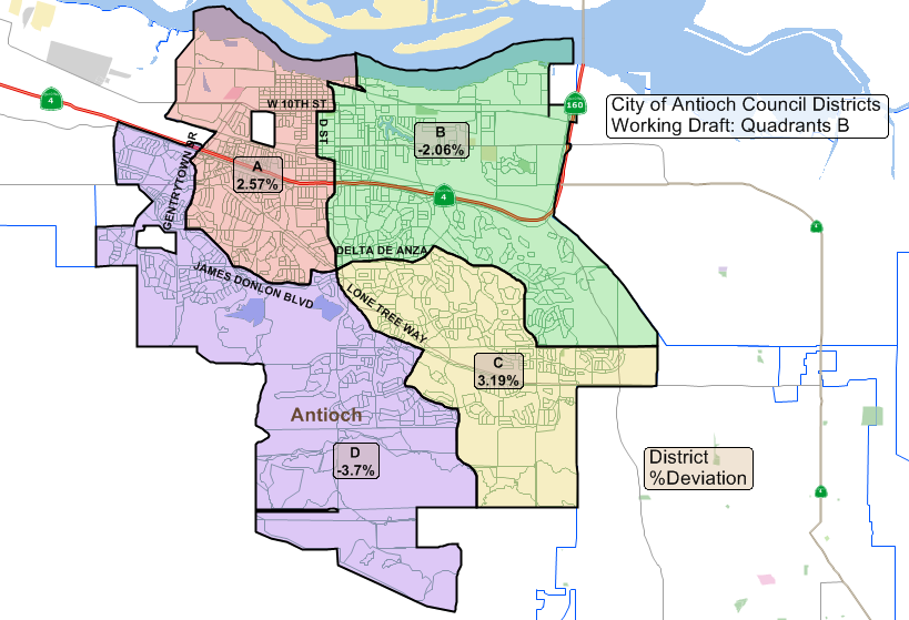
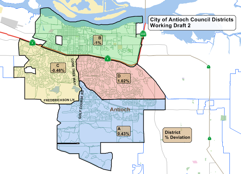
The revised quadrants map finalized at the council workshop on Tuesday, April 10, 2018.

By Allen Payton

During the special workshop of the Antioch City Council on the maps for the district elections on Tuesday evening, April 10, they made changes to the Quadrants B map. It also got a bit contentious among the council members at the end. Fewer than 25 members of the public were in attendance.

The council considered realigning the Quadrants B map along the current congressional district boundaries. Councilman Tony Tiscareno and Mayor Sean Wright offered the most proposals for moving the lines to that map.

There was a discussion about the population growth since the 2010 Census, which the council must use for the basis of dividing the city into districts. One argument was that the population grew more on the south side of Highway 4. However, Mayor Pro Tem Lamar Thorpe disagreed.

“We can’t assume all the growth went to south and southeast Antioch,” he said. “I don’t put a lot of stock in the difference between 102,000 and 114,000 population. Many of the homes were empty.”

Interim City Attorney Derek Cole said, “Quadrants A would address the issues of illegally diluted voting. It didn’t really respect communities of interest.”

Wright offered some changes to the quadrants map, which the consultants from Q2 made.

Councilwoman Monica Wilson said, “It seems to be the changes that were made…we’re splitting communities of interest.”

Tiscareno said “I’ve gotten many calls.”

Thorpe said, “I’ve gotten many calls over on Hillcrest and Deer Valley. People looked at me like I was crazy when I proposed the quadrants.”

Cole then suggested the council rename the revised Quadrants B map to Quadrants C.

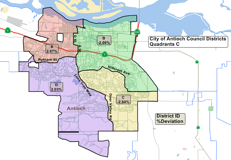
The revised map uses major thoroughfares on the south side of Highway 4 as the dividing lines, such as Putnam Drive, Lone Tree Way and Deer Valley Road, as well as the Delta DeAnza Trail on the west side of the city.

Public Comments

Marty Fernandez was the first member of the public to speak.

“I favor that C, now in the districting,” he said. “If one council member is good for downtown, two would be better, right, Lamar? No one has mentioned how this would affect Viera Lane. How many people live out there? How much is this going to cost the city? Let’s have some transparency, here.”

Garry Holman introduced himself as “a former two-term member of the city’s Economic Development Commission.”

“The city government has promoted or professed to promote a common interest,” he said. “Avoid the creation of a wrong side and a right side of the tracks, namely Highway 4. I don’t think Antioch is big enough for district elections.”

Holman said it will create “clear balkanization.”

“I oppose Working Draft 1,” he stated. “Working Draft 1 will only codify the right side and wrong side of town.” He concluded his remarks saying he supported the quadrants map giving downtown two council members.

Former Councilman Ralph Hernandez said he opposes districting and submitted a letter about his views.

“This started out as a racial threat, based on the Latino vote of other cities,” he said. “It does not represent Antioch. I’m very angered that the Latino community is being used for a lawsuit against Antioch. “

Former Councilwoman Norma Hernandez spoke next, saying “Looking at the maps to me that’s gerrymandering. The city attorney can only advise you. The decision is your own and the consequence is your own.”

“This totally disenfranchises the voters of Antioch,” she added. “A house divided against itself you know that can’t stand.”

Jeffrey Klinger was the last to speak saying, “I haven’t heard anything that’s changed my opinion of districting. It’s difficult to feel good about it as a citizen. But you had my sympathies.

My personal preference would be Quadrants C. I have a visceral reaction to using Highway 4 as the dividing line.”

Cole said the council will bring back the final decision on May 8 and you would bring back two maps.

“What I need tonight is do you want one map or two maps? he asked. “We have to publish these maps in the paper. We’re kind of at a critical juncture, here.”

Accusations of Self-Serving Gerrymandering by Councilmembers

The council members then discussed the matter, and it got a bit heated.

Thorpe said “this is costing us something and the public should know how much. Marty, I would agree with you that North Antioch deserves two council people. When you look at B section what you see there’s a lot of people who live in that area. If you’re an incumbent in that area you won’t be going anywhere for a very long time. The voting pattern…dilutes the voting power for north Antioch. What these maps don’t do, in any of these maps, it doesn’t create a Latino majority district. We won’t be creating a majority minority district. We’re a pretty integrated community. Your comments about downtown Antioch I couldn’t disagree more. I think it’s interesting how everyone uses Highway 4, uses this as a demarcation line. The survey we took the people north of the freeway are very unsatisfied with the city of Antioch. Two-thirds of the people in southeast Antioch were satisfied. People are not happy in north Antioch. Some of that has been caused by the continued expansion in south Antioch. We didn’t look at other cities, we looked at Antioch and that’s how we learned of the racially polarized voting.”

Councilwoman Lori Ogorchock said, “I too went out and walked. I went to the C Street area…showing them the maps. Most of them didn’t know we were doing the districting. I left over there and went to Beede Park. The majority of them I got signatures wanted Quadrants B. Several of them from C Street wanted Quadrants B. We are listening to what everyone is saying. We got several emails that were boilerplate emails. They’re talking about the school districts. They’re going to have five districts. So, what the school district does has nothing to do with what the city does. I know it’s a hard thing. We talk about Rivertown. It’s not everything below Highway 4.”

Tiscareno then said, “This is a very difficult situation. I had the pleasure to meet with some of the constituents, especially those who support Working Draft 1 and heard their stories. A lot of people did get a hold of me in regards to the Quadrants map. There are three maps that we’re looking at. This was really rushed…put toward us in a manner we might be making rash decisions. I thought we were going to have an ordinance on this. Putting forth a map before we have an ordinance is an oxymoron to me. We’re back down to two. If that’s what we’re doing, then I would love to hear from the public. The ones who are adamant…I heard you. But there’s 116,000 people in the community and I want to hear from others. Working Draft 1 and Quadrants C.”

Wilson then said, “I haven’t put out my preference. I haven’t touched any of the maps. I’m uncomfortable with C because I feel like a little gerrymandering was going on. I too have been out in the community. The majority is Working Draft 1. At the end of the day moving the line there’s a preference to you.”

Wright weighed in saying, “I’m still against this. But we’ve been told by our attorney that if we fought this we would probably lose. We have to be responsible with the fiscal. How do we keep Antioch the best that we can over the long-run. I’m OK with Quadrants C.”

He then defended the changes he made to the quadrants map saying, “When you gerrymander you draw crazy lines to make sure you have the people in your district. When drawing the lines, I went down the major thoroughfares. I didn’t look at which family is where. I’m in favor of Quadrants C going forward and Working Draft 1.”

Thorpe said, “she’s not referring to the changes that Mayor Wright was doing. She was referring to the area over here (pointing to the change in lines between Districts A and D of the Quadrants map). This is why I hate this process. It shouldn’t be in the hands of politicians. Don’t dismiss the people who are trying to participate in the process. Whether they are signing a petition or signing someone else’s letter. I find that particularly unfortunate.”

Tiscareno was not happy saying, “when pointing toward the Gentrytown are, when looking at Working Draft 1 or Quadrants B the Gentrytown area remains intact. Quadrants B or C go against me. Working Draft 1 actually benefits me. But I’m doing this for the benefit of the community. I do take some offense that (others were saying) gerrymandering is taking place.”

Cole then said, “either Working Draft 1 or Quadrants C, legally speaking either map would be sufficient if enacted…in compliance with the Voting Rights Act. I feel I have direction from council to move forward with Working Draft 1 and Quadrants C.”

The workshop adjourned and the council went into regular session.

The council meeting for deciding on which map the council will adopt was moved to May 8 from the special meeting that was previously scheduled for Monday, April 23. According to City Manager Ron Bernal the council can’t adopt an ordinance at a special council meeting and the City Attorney got permission from the other attorney threatening the lawsuit to extend the deadline to complete the process.

Antioch Council to hold special workshop to finalize district elections map before regular meeting Tuesday

Monday, April 9th, 2018

By Allen Payton

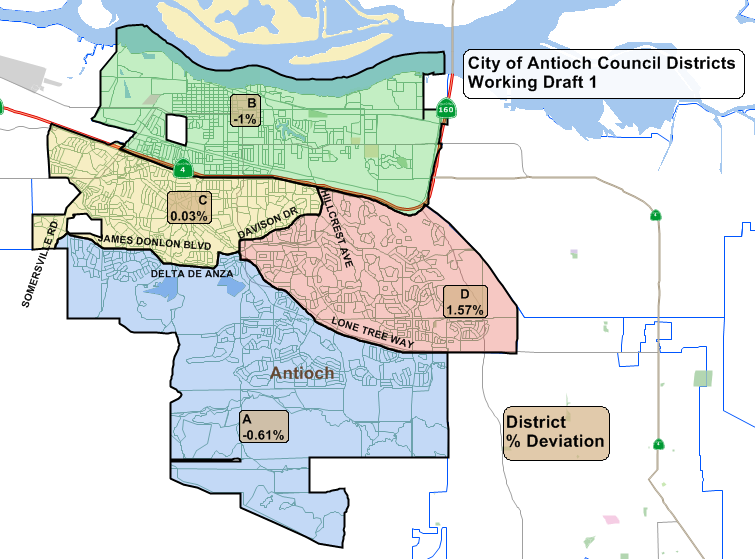
On Tuesday night, April 10, 2018 the Antioch City Council will hold a special workshop at 5:30 p.m. prior to their regular meeting at 7:00 p.m. to consider finalizing the drawing of the map for district elections. The council is considering two maps, one which creates a district north of the freeway known as Working Draft 1 and a second, known as the Quadrants which splits the north side of the freeway into two different districts.  The council will make efforts to redraw the Quadrants map but decided at their last meeting to leave the Working Draft 1 map as it is. Please see related article, here.

During their regular meeting, the council will hold a public hearing on and vote whether or not to even move forward with district elections. See complete agenda by clicking, here.

If so, then at a special meeting on Monday, April 23 the council will vote on which map they will use and finally, whether to implement district elections in 2018 or 2020.

The meeting is held in the Council Chambers at 200 H Street in Antioch’s historic, downtown Rivertown. It can be viewed on local TV channel or via livestream on the city’s website at http://www.ci.antioch.ca.us/CityGov/citycouncilmeetings.htm.

Antioch council narrows choices to two very different maps for district elections

Wednesday, March 28th, 2018

Will hold another workshop at 5:30 p.m. on April 10th to make changes to “quadrants” map; final vote at special meeting on Monday, April 23rd

By Allen Payton

After two-and-a-half hours of hearing vary disparate comments from the public, and a lively debate and discussion by council members, the Antioch City Council voted to narrow down the number of draft maps for the council district elections from four two to. The two final maps, referred to as Working Draft I and Quadrants B offer very different options and the public comments reflected those differences. Some speakers still advocated against changing to district elections, saying it will divide the city and cause council members to compete for tax dollars for projects just in their districts.

(To watch the complete council meeting, click here: http://www.ci.antioch.ca.us/CityGov/CouncilMeetings/032718/)

Interim City Attorney Derek Cole mentioned he had received emails prior to the council meeting and that “six emailers…want to preserve a community of interest above Highway 4, a Change.org petition with 52 signers of wanting to “Designate Hillcrest/Deer Valley Corridor as a Community of Interest during districting.”

Working Draft I Map

The Working Draft I map creates a single district on the north side of Highway 4 and that was supported by most of the speakers, many of whom live in that area of the city. The arguments were that there hasn’t been an elected city council member from the north side of the freeway since the 1980’s and the people there want someone who lives in that part of town to represent them. It was pointed out that appointed Council Member Martha Parsons lives in the north part of town and served on the council in the last decade. However, she was not elected when she ran at the end of her appointed term.

Most of the speakers in favor of Working Draft I were Hispanic, members of the East County Regional Group, and live in that part of the city, two of whom spoke in Spanish and used a translator. Another speaker in favor of the Working Draft I map was former Antioch School Board Member Joy Motts, who lost for re-election in 2014 and lost for election in 2016 and is the only candidate for city council who has filed paperwork declaring her intention to run this November.

That map garnered the support of Mayor Pro Tem Lamar Thorpe and Councilwoman Monica Wilson. Thorpe only wanted to advance that map for a final vote at the council meeting on April 10th. He argued that Motts couldn’t get re-elected because people on the south side wouldn’t vote for her and viewed her “as old Antioch and dismiss  her.” Wilson echoed Thorpe’s comments, giving what sounded like an endorsement of Motts’ candidacy. However, Mayor Sean Wright pointed out that Antioch School Board Member Diane Gibson-Gray lives on the north side of town and was able to get elected.
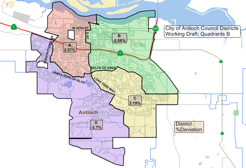
Quadrants B Map

The Quadrants B map had the apparent support of Wright, and Councilmembers Lori Ogorchock and Tony Tiscareno, who agreed with the public speakers in support of it, that it would allow two council members to represent portions of the north side of Antioch. The speakers in favor of that map, including former Antioch Mayor Don Freitas, argued that in order to get something accomplished it takes the votes of three council members and with two representing the north side of town, that area will have more advocates on the council, making it easier to get to three votes.

However, there was an effort at the end of the hearing by Wright to make some changes to the Quadrants B map, to accommodate some of the concerns expressed by members of the public. As the hour was getting late, the consultants said any change to one district would cause a ripple effect among the other districts from a population standpoint, and there were still three items on the agenda that staff said needed to be dealt with, it was decided to hold one more workshop, prior to the April 10th council meeting, at 5:30 p.m. that same evening.

Interim City Attorney Derek Cole explained to the council that they have three things to decide at their meeting on April 10. First, they must vote whether or not to move forward with district elections, and if so which map to use and when to implement them, either this year, or wait until 2020 to do so.

The council voted unanimously to support moving forward both maps. They also agreed to hold a special meeting on Monday, April 23 to accommodate Ogorchock’s schedule, as she will be out of town on April 24, and to ensure they complete the process in the legally proscribed time frame to avoid facing the threatened lawsuit, which started the entire process, in court.

Public Comments

Former Antioch Councilwoman Norma Hernandez was the first member of the public to speak saying, I can’t believe this is the United States of America and this is happening in the City of Antioch. This is the worst thing that could happen to our city.

We’re putting people against each other. At the same time, we’re disenfranchising the voter. They can only vote for the mayor and one member. They’ll only have two people beholding to them. I can’t believe this man who has come to our cities and is going to other cities is getting away with this.

You represent the whole city. You will only represent one district. The sharing, behind door deals, with sharing the money. The whole community gets ripped off. Just because the state of California is running games it doesn’t mean we have to go along with it. I want to be able to come to my city council and if I don’t like you, I want to be able to recall you. I’m totally against this. Don’t let the State of California change the United States of America.”

Former Antioch Councilman Ralph Hernandez said, “First off, I am opposed to the district elections. I think we should keep it here in Antioch the way it is. I don’t want you guys to be scared. The city gets a lot of lawsuits. You hire consultants and help to fight those lawsuits. This is something you as a city council as a whole to fight this. Governor Brown made it easy to where you don’t have to go to the community if they want district elections. You should have gone to the community and asked if we want district elections. I understand the lawsuits. I understand the threat. The attorney and whoever is behind this. They’re making money off this. Why should Antioch be the stepchild to this attorney. You need to stand up. You need to show the community you really care about the community. How many of you decided not to represent a particular area or a particular group of people? You all agreed to represent each and every person who lives in Antioch equally. If you’ve since decided not to you should sit down and let someone who wants to represent everyone take your place. Segregation is something that America has gone through for many, many years. This is segregation. It’s discrimination. That’s really what is going to be accomplished. You’re pitting areas of our community against each other.

Joette Milano Wright said, “I am in support of working Draft #1. I don’t want to see the old Antioch divided.”

Donald Bright said, “I was opposed to districting…but since we are forced into this situation, I am in favor of Working Draft 1.”

Brenden Olaski said, “I am a member of the East County Regional Group. We trust a new system will not change you representing all of Antioch. It will ensure the demographic challenges facing Antioch. North Antioch has a large immigrant community. It is critical that it has its own district. We have not had a council member from north Antioch since the late ‘80’s. I ask you to form one district in north Antioch and support Working Draft 1.”

Ellie Householder said, “I felt like I just had to speak. I am in full support of the districting. I was born and raised in Antioch. Proposed, Working Draft 1 makes the most sense. D Street is not a logic place to split that up. People have issues with isn’t Highway 4 a divider? But it is a cultural divide. It’s not about segregation it’s about representation. That 3/10 council meeting was the first one I’d ever gone to. I just think that representation is a good thing. Being from the north part of Antioch, I’m confident that who ever I vote for will represent all of Antioch. There are things in each neighborhood that everyone cares about. My part of Antioch hasn’t been active as far as registration goes. I think we’ll get a lot more engaged voters.”

Antioch Planning Commissioner and brother of Joy, Kerry Motts said, “None of us are too happy the way this came about…under threat of a lawsuit. I believe the two quadrant maps are inherently political…and dilute representation north of Highway 4. I believe council members as a whole will represent all of Antioch. Working Draft #1 is best. I think this should be done for 2018.”

Christine Clark said, “I am…a member of East County Regional Group. I do live in the Rivertown community and support creating one district north of Highway 4. It also creates a more democratic Antioch that reflects our values. Working Draft 1…is the best plan for a strong Antioch.”

Deborah Polk said, “I am in support of creating one district north of highway 4. I am in opposition of splitting this are into two or more districts…diminishing the capacity to be represented. Working Draft 1 is the only reasonable, viable and equitable decision.”

Tina Price said “I am here for the Change.org petition, put together with Ms. Walker, referring to designating the Hillcrest/Deer Valley corridor as a community of interest. She then read from the petition, which can be seen at the link, above.

Susana Williams said, I too support of the first map. First and foremost, this has nothing to do with segregation this is about representation. None of you when elected said you were going to only represent your neighborhood. It’s just much fairer representation. We’re not talking about the numbers of people who live in these areas. North Antioch has gotten the short-end of the stick in so many ways because the focus has been on new part of Antioch. No city has won that has fought this. It’s a colossal waste of money. I would definitely like to see this happen.”

Ellen Ramirez spoke in Spanish and used a translator. “We need to make sure his process is fair. I value democracy…in the drawing of districts. At this time unfortunately, this is not the case because low income people don’t have representation on the city council. It is difficult for all residents to have a say in important decisions. I believe this is important to support a community north of Highway 4 because it represents communities of need. I think you should form a single district north of Highway 4. It will help a child of a poor neighborhood as a child in a neighborhood with more resources.”

Evelyn Lopez said, “I am also a member of the East County Regional Group and a resident of Antioch. Ask you to vote for Working Draft 1. We need our own district and our own representative.”

Sylvia Angeles, who spoke in Spanish using a translator, said, “I am a member of East County Regional Group and I have been a resident of Antioch for many years. She wanted to make sure “the maps are fair.”

“I am a resident of the community north of Highway 4,” she said. “As a mother I am concerned about the crime…especially on 18th Street where I live. I feel powerless because there is no representation for my neighborhood. Volunteer work is not enough. We need to work together in Antioch…to find the solutions to the problems of our community. This person will understand our needs. We all have the same needs north of Highway 4…with one representative on the city council… Today I come to speak out for the first time because this issue is important. I ask you to support Working Draft 1 to create a single district.”

Verlyn Leon said, “A resident of Antioch for more than 15 years. I greatly value having a democratic process and I support creating a single district north of Highway 4. Has different needs than other parts of Antioch. An accessible representative. Someone who lives our realities. That is democracy and is how you make our city strong. If you divide north Antioch it will create more inequality…we run the risk of being a minority. It is fair, it is democratic and the right thing to do.

East County Regional Group Vice Chair Freddie Leon said he and his wife were celebrating their 19th anniversary, which garnered applause from the audience. “This is more important,” he said. “I have lived in Antioch for more than 15 years. I want my city to be a safe and secure place to raise my kids. Many people living north of Highway 4 are immigrants and people of color. The community is strong. They go to church and try to improve the community. I know it’s a really hard task but they are trying. North of Antioch above Highway 4 needs to be one entity. I support working Draft 1. It is the only one that is fair.

Samson Knight said, “I am just your average community member. I was at the special meeting on March 10th. Some of the comments made against districting kind of disgusted me. Many of these supporters backed the quadrant system to keep the council responsible to the average needs of our community. If anything, the balkanization of Antioch will be created by ignoring these differences. We need reasonable…districting. The 4 is not an arbitrary boundary…albeit man made.”

Antioch Economic Development Commissioner Tim McCall said, “I sat out there and listened to many people speak about…dividing the downtown area. That is exactly what we’re doing to the City of Antioch. Are we really dividing our city into four areas? I guess we are. If you divide into the four sections, no matter how you did it, you’re going to have a problem with new development and redevelopment. He suggested a “sliced bread” approach…making all council members responsible for each part of Antioch. I’m wondering if any of the council members are thinking about voting for one or more of these plans because you can’t have two people in one district…people will begin voting for self, not for city. I ask you to not rush this through…but delay it until 2020.”

Dr. Terry Ramus said, “Our family has lived here for 33 years, in our current house for 28 years. I was at the mapping meeting…I am opposed to this entire process. My caution is that sometimes you might get what you wish for. Folks are saying keep all of the area north of Highway 4 in one district. But, you have one vote. You still have to get two more votes. I have been coming here for years” speaking for things in the north side of the freeway.

“Is Beede Park more related to the Madill area than say the Putnam area?” he asked. “The idea that everything north of Highway 4 is the same…these are false differences. The one that I support is to unite the city. Many of us have worked to reduce that problem. Either quadrant is fine, frankly. It causes the city to try to work more together. The one I would pick is the point.”

Jennifer Hughes said, “I’ve lived in Antioch since 1995. The second home I’ve bought is in the downtown. I walk the dog I go down by the river. I’ve listened to the entire city council meeting. I thought about it a lot. I’m in favor of districting. I’m in favor of Working Draft #1. Because it’s not working now. I really do think that each section of town will be better served by separate representatives. Each of you would be a specialist for your area.  You can’t be fully informed of all the needs of the city. Specializing is a good thing and I think it gives us the representation the way it should be. The quadrants are keeping things the same.”

Warren Lutz said, “This is the first time I’ve been up here. I think the districting is great. I also support Working Draft #1. I live off of Hillcrest and Laurel. Working Draft 2 splits my neighborhood unnecessarily. I’m appalled to hear there’s been no representation north of Highway 4 since 1994. That would be one representative more than they have now.”

Karen Johnson said, “When I first read about the districting my heart dropped. I moved here in 1994. Most of my activities have been north of Highway 4. I’m from the Midwest. Antioch reminded me of where I came from. One town. Regardless of what side of Highway 4 you lived in. I’m hearing a lot of artificial excuses of why we should split up. We’re all experiencing crime. I never experienced or saw anyone who was representing Antioch that wasn’t thinking of the whole city. We have the low-income homes in Rivertown. There’s always been an effort here to address the needs of everyone. I don’t think we need to get in this mindset that we’re different because of what part of Antioch we live in. We don’t really have real differences here that we can’t address. Let’s face it someone decides to sue us because we don’t have districting it’s like the devil trying to push us into dividing ourselves when it doesn’t have to be that way.”

Antioch Planning Commissioner Ken Turnage said, “Personally I like Quadrant B if we’re going to do this. I can talk to any of you, right now. If this goes through I got only one person to talk to. Growing up here, I actually moved to Antioch in 1972. What I hear in here, are communities of special interest. Are we looking to have…quadrants that work together…or pitted together like I’m hearing, tonight? I want people who are going to vote for what the entire city needs. If we divide this out by our special interests…then we are going to have nothing but fighting. I believe people will once again look out for what their area is because they want to get reelected. Let’s not look at special interests, let’s look at communities of interests.”

Janet Costa said, “I’m here tonight to ask council to support Working Draft 1…and only advance this one, tonight. I’m excited about the possibility of a district devoted to north of Highway 4. I understand that this change does not mean my needs will not be met. I would like to say on behalf of all of the Regional Group we have worked with the council for more than a decade. This is not personal toward the council. It gives them a chance to participate in the electoral process in a more equitable way.”

Francisco Nazario said, “I’ve been a resident of Antioch for a short four years, but I’ve had the opportunity to visit parts of Antioch. The United States was created as a representative republic…which is made up of districts, which is also echoed at the state level. It’s a question of the size of population. Change is a process. It’s human nature to resist it. Cities have tried fighting it. Get used to it. It’s coming. Make the best of it. I think Working Draft 1 makes the most sense from kind of a historical perspective. Each group would like to have a person to represent their area. They have someone directly to go to…and if they don’t do a good enough job they elect someone else. Antioch will continue to grow. Get used to it it’s coming. I think everyone on the council has a fiduciary responsibility to protect the finances of the city. I think we need to focus on implementing this districting and focus on the best job you can do as a council and we can do as citizens.”

Former Mayor Don Freitas said, “Well I’m 63 years of age and I was born in the city of Antioch. I was born in the hospital on 6th Street. I also had the great fortune of representing Antioch both locally and regionally. A lot of people, you’re always going to think of Antioch’s best interests. I absolutely hate this districting plan is being shoved down the throats of the people of Antioch. You can fight it or we can create four different districts. The decision you make is going to last forever. It’s critical for every decision for each census when we have to move the lines. Two things are critical. Shape and balance.

I absolutely do not like this alternative (Working Draft I). Politically you will isolate the downtown area. Be careful what you ask for you might get. You might have a representative in this schematic.

Quadrant B…in this case you will have potentially two representatives.

I strongly encourage you start in 2020. Alternative one does not provide balance. It does allow one person to rant and rave about the needs of the downtown area.

The Antioch Council spent approximately $25 million uniting…A Street to 2nd Street in downtown. We wanted to prepare the downtown for growth. I would suggest the first one and Quadrant two be the options to go forward. The first alternative is going to bring back that war full force. Please, God, don’t embrace that alternative.”

Joy Motts was the last to speak saying, “I was also born on Sixth Street in the same hospital (as Freitas). I couldn’t disagree with you more. We already have the situation of have and have nots. Although this isn’t a panacea. Clearly the people of the community are speaking out saying they want to keep the north part of Antioch together. I agree. One of the reasons I ran for school board was because…Antioch High School was falling apart. I lived in north Antioch…I knew the needs there. It’s only because I brought that forward…we brought it before the people and they supported it. I’m just saying this is going to work. I have trust in you. We’re all adults. We’re one community, one Antioch. But we need representation for those communities. Your Quadrant map literally divides the (Rivertown) Preservation Group. Keep north Antioch together. It won’t divide this community. It will empower this community.” (Editor’s Note: The Quadrant B map does not divide Rivertown, which is bordered from 10th Street north to the river. The section divided by that map is south of W. 10th Street).

Council Discussion

Mayor Wright said, “We allowed every person to speak for their full five minutes because of the passion. At the next meeting we may cut your time down.”

Mayor Pro Thorpe was next to speak saying, “This is a big issue and you know Antioch has gone through a lot of change. There’s a lot of change happening very rapidly. I don’t like this process. This should have gone to the voters. But, as I’ve maintained throughout this process…I have a difficult time with these quadrants. I’m not a big fan of them. Population…I go beyond that and look at voting patterns. The quadrants do a disservice. There are just some claims that are made that are not accurate. It is true the last person to be elected to the Antioch Council was in the 1980’s. But the last person to serve was Martha Parsons. That will be the same. Because southeast Antioch has grown. I wish Joy Motts was still on the school board. But, she’ll never get elected because people in south Antioch look at her as old Antioch and dismiss her. This is not dividing up the city but creating legislative districts. Some folks made some claims there will be some infighting and back room deals. I picked up the phone and called Berkeley…and they said the divisions of…the hills and the flatlands have always been there. The same for Elk Grove.

“You find there is infighting but it’s because of personalities not because of districts. For anyone to call this a special interest…this is a community advocacy group. The special interests are the ones financing our campaigns…who focus on growth in southeast Antioch. Because that’s how you get elected in Antioch. It’s through single member districts that you can raise enough money from your neighbors…so you don’t have to hitch a ride with developers, Realtors or unions.

I’m not supporting any of the quadrants because they don’t fulfill the purpose.

“The city council did not advance them. Two city council members advanced these quadrants… these arbitrary lines that we’re coming up with these quadrants.”

“The Brown Act still exists,” he added. “You can still only talk to one other council member, now. It will be the same under the district system. It’s arguments about nothing.”

Councilman Tony Tiscareno was next to share his thoughts saying, “I’ve been actively opposed to districting. The reason why is because we have been submitted by force which shouldn’t been submitted to the city. People have been talking about geographic. It was submitted on another nature, with which I disagree. For the last 15-20 years that I can count we’ve had a diverse city council. I’m quite upset with the way it came about. I don’t like any of the maps. I want to represent…the entire city. I understand and agree there’s a lack of representation on the north side of the city. It’s why I’m listening to the districts, right now. I’m kind of offended…I kind of feel bad. I’m only a block away from the freeway so I’m kind of representing the north waterfront. I’ve always felt I’ve represented that part because that’s where I grew up. The true part of Antioch has always been the north side…You do in some respect have someone who cares about the older part of Antioch. If we’re going to entertain this sort of thing, I want to respect the people. So, I’m willing to consider Working Draft 1. But, I’m not saying I’m going to vote for it. The quadrants seem to be something that is fair. I seem to think that if you have two representatives for one particular area it’s better than one.”

Wright said, “One of the things I may propose…is how do you adhere to what the letter dictates, how do we go about not getting sued. We have a census in 2020. One of my problems is we’re using numbers from 2010. So, these lines that are being drawn are not based on true numbers. We’re going to wait until 2020 after the Census occurs. I’m not sure if that will satisfy the lawsuit.”

Cole responded, “The Census will be done in 2020. But the numbers will not be out until after the November 2020. I feel comfortable if we phase in…because of the systemic change involved, because we have Latino representation on the council. But…we would have to get past two election cycles to get to the Census.”

Tiscareno said, “Then I’m going to suggest another extreme and that’s to have the elections in 2018. Which map, it really doesn’t matter. In my mind when we’re running to represent all of Antioch. You implement whatever map is supported by the council, you have everybody run so there’s no hard feelings of who will run.”

Cole responded with, “By law we cannot abridge their terms. If you do implement in 2018 those two council members would be allowed to serve until 2020. Do you want to phase in the two districts you want to run this year…then you have to choose which districts they will run in. Or you choose to phase in at-large elections for two years, then everyone runs in 2020.”

Tiscareno then said, “At least narrow it down to two maps. I’m willing to vote no on this right now. I’m willing to stay at large. Quadrant B with some possible tweaks to that. If we implement in 2018 or 2020 I really don’t care.”

Councilwoman Monica Wilson was next to speak saying, “Thank you to everyone for reaching out to me. Joy, yes you did some wonderful work on the school board. You’re probably the hardest working person north of Highway 4. Why aren’t you on the school board? It’s because of the dilution of vote north of Highway 4.”

“Going forward with this districting…I am for it. Draft Map #1 seems to be the most popular one so that’s what I’m going with. I’m leaning toward Draft 2 because I want to keep north of Antioch together. Quadrant B divides Rivertown Preservation Society.”

Councilwoman Lori Ogorchock then said, “I don’t like this idea. It’s probably a good thing in the long run but the way it’s going I don’t agree with. The people I hear from are the people that have heard what we’ve said. When they hear us talking about it…I hear lots of people saying they don’t like the downtown being in one district. If you have the quadrants you have two people representing the downtown. I kind of like the idea of the quadrants. People came up and said they don’t like the idea of one vote for the downtown. I grew up in downtown. The freeway did divide the town. What made it worse was the ZIP Codes. It made it ten times worse. It is one town. We have to listen to everybody. Communities of interest are being listened to.”

Wright then said, “the idea that you can’t win if you live downtown is just not true. I don’t know where they all live. I don’t look at where they live when I’m voting. I look at if they’re going to do a good job. Looking at Quadrant Map B, I have some issues with the lines. Is there a reason A Street isn’t the divide?”

Q2 consultant Jaime Clark responded, “That was for population and to respect communities of interest. To keep the C Street group COI in tact and not cut through these smaller neighborhoods.”

Wright then asked, “Do we just ignore that there are 15,000 people in southeast Antioch that aren’t being accounted for?”

Clark said, “We have to use the 2010 Census.”

“So, we’re just ignoring those 15,000 people,” Wright stated. “The C Street area, they’re closer to downtown. So, I think they should be part of downtown. He then suggested some changes to the Quadrants B map.”

Clark then switched over to a live map to draw changes.

Tiscareno then said, “the concern I have is the numbers we’re using the 2010 Census really don’t reflect what we’re looking at now. I’m also looking at Congressional districts to stay within a community of interest.”

Cole said the council could hold another workshop.

Wright said, “there’s a motion to move forward Working Draft 1 and Quadrant B.”

Cole responded, “I can draft an ordinance that adopts a four-district system. I can also provide two options that implements districts in 2018 or 2020. You only have to introduce an ordinance at your next meeting. I will work with the consultant to make some changes.”

Consultant Clark then shared, “I don’t feel I have enough information from council offline without specific, detailed input.”

Cole explained to the council, “If you want to look at Quadrants C…then we can bring that back at the next meeting.”

Q2 consultant Karin MacDonald said, “The problem is any changes she makes to one district will have a ripple effect. So, we’re going to need your input. I’m not sure if this is possible to do this quickly at the beginning of the next meeting.”

Tiscareno said, “Maybe we start three or four hours earlier. I think it’s going to take more than an hour. The meeting is going to be packed. We’re going to have community input. It’s going to take some time.”

The council then decided to start the workshop at 5:30 p.m. following a closed session at 5:00 p.m. on April 10th.

Cole then pointed out, “The maps have to be published, but right after the 10th we can have them in the newspaper right after that. The reason we have to finalize the map at the first meeting in April is because we have to advertise it in the paper seven days before the meeting.”

Ogorchock said, “I will not be at the 24th meeting. So, we have to get it done.”

The council then settled on a special meeting on Monday night, April 23rd.

On April 10th 5:30 p.m. the council will have a workshop on the final map. At the 7:00 p.m. meeting they will take initial votes on the matter.

On April 23rd the council will consider the adoption of the final map.

Wright then said “we’re going to come back with Working Draft 1 and Quadrants B. And we’re going to work on those changes that night.”


Antioch Council to consider narrowing four alternative district maps to two at Tuesday meeting

Monday, March 26th, 2018

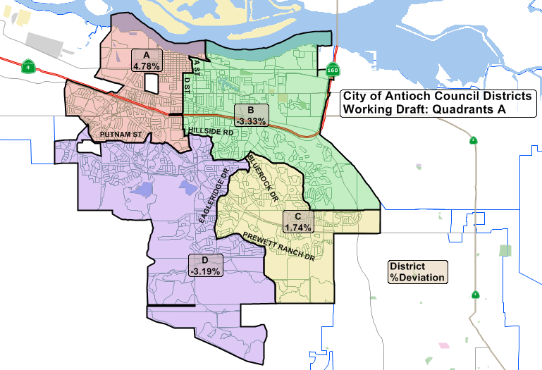
One of the two “quadrant” maps of proposed council districts created in response to the input given at the March 10th council meeting.

By Allen Payton

At their meeting on Tuesday night, March 27, the Antioch City Council will consider narrowing down the choices from four to two of the alternative maps for creating the new council districts in time for this November’s elections.

At the March 10th meeting held at the Nick Rodriguez Community Center in downtown, which lasted three hours, the council took input from the public and added two alternative maps to the two developed by the consultant. (To watch the video of that meeting, click here – http://www.ci.antioch.ca.us/CityGov/CouncilMeetings/031018/) (To see the staff report for that meeting, click here: ACC031018 Districting)

One idea and alternative map of increasing the number of council seats from four to six, for a seven-member council including the mayor, was rejected at that meeting.

This is one of two proposed council district maps that keeps all of the area north of Highway 4 in one district.

According to the staff report for that meeting by Interim City Attorney Derek Cole, the council can decide to implement the district elections in one of two ways. That read as follows:

Timing of lmplementation of District Elections

A separate issue for which Council direction is necessary is on when to have the district elections begin. To this end, I include correspondence from the County Registrar of Voters, who has expressed concerned about his office’s ability to implement district elections in the upcoming general election this November (which is the first available election in which Antioch could switch to by-district elections.) I question whether the Registrar has the authority to not implement districting elections starting this year, but I did want to convey his statement to the Council for your consideration.

I note that two councilmembers have been elected for terms through 2020. Consistent with Government Code section 34873, it does not appear these terms can be abridged. Thus, the options appear to be to partially implement district elections starting in 2018 or to implement districting all at once beginning in 2020. Possible scenarios could include the following:
Staggered rollout of district elections starting this year. In this scenario, the City would keep the two at-large seats of the councilmembers whose terms do not expire, and it would implement two of the four districts for this November’s election; then in 2020, the City would replace the two remaining at-large seats with the two other districts. This would keep the current staggering of elections in which two councilmembers are up for election each election cycle.

Implement districts all at once in 2020: With this option, the city would start all district elections in 2020, but provide that half of the districts would initially be for 2-year terms, while the other half would be for full 4-year terms. Then, in 2022, the districts for which 2-year initial terms were held would convert to 4-year terms. This would allow for the Council to maintain a staggered election system. (What this would mean for the two council seats that are up this year is that those would still be elected on an at-large basis in November, but they would only provide for terms of two years.)

County Registrar of Voters’ Concerns

County Clerk-Registrar of Voters Joe Canciamilla said that the best way to implement the district elections, this year would be for the maps to be drawn using existing precinct lines. According to Jaime Clark of Q2 in her presentation at the March 10th meeting, less than five precincts in Antioch have been split in Map 1.

At their April 10th meeting, the council will first decide to approve switching to district elections and then, if so, which map to approve for the 2018 and 2020 elections. Finally, they will decide whether to have a staggered rollout in 2018 or implement district elections all at once in 2020. If the council approves district elections, whichever map they choose will last until 2022, after the next census in 2020 and redistricting in 2021 when a new district map will have to be created.

The council meeting begins at 7:00 p.m. in the Council Chambers at 200 H Street in downtown or it can be viewed on local cable access channel or via live stream on the city’s website at http://www.ci.antioch.ca.us/CityGov/citycouncilmeetings.htm.

Deputy DA’s endorse Graves for Contra Costa District Attorney

Tuesday, March 13th, 2018

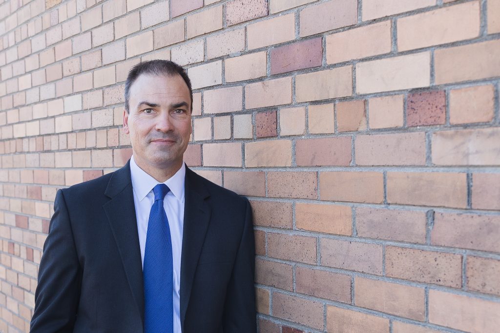
Contra Costa Senior Deputy District Attorney Paul Graves. Photo courtesy of Paul Graves for DA

The Contra Costa County District Attorneys’ Association endorses Paul Graves for District Attorney.  Delivering the news, Association President Aron DeFerrari noted “Paul has the experience and integrity Contra Costa deserves in its next District Attorney.”

Stephanie Kang, a DAs’ Association Board Member, noted “Paul Graves is exactly the type of person who should be leading the change and reforms Contra Costa needs.  Paul Graves had the courage and leadership to stand up against Mark Peterson’s misconduct and run against him even though taking a stand risked Paul’s career.”  

Lauren Whalen, another Association Board Member, and lifelong Contra Costa County resident, said “Paul’s actions put Contra Costa first and we know he’ll continue to do so as District Attorney.”

Steve Bolen, an Association Board Member noted “Our prosecutors are eager for change. We embrace the idea of a fresh start and the possibilities it offers. Most importantly, we care about the safety of the residents and communities we serve.  We know Paul Graves puts public safety above politics, that’s what matters to us.” 

The people of Contra Costa deserve an experienced, trusted prosecutor who can provide the leadership needed to keep our communities safe.  Paul Graves alone offers both that experience and integrity. He should be Contra Costa’s next District Attorney.

Environmental groups, Antioch residents submit initiative seeking third vote on new home development area

Friday, March 2nd, 2018

By Allen Payton

On Thursday February 8, 2018 a coalition of Antioch residents and community groups, entitled the Antioch Community to Save Sand Creek, submitted the text of the “Let Antioch Voters Decide: The Sand Creek Area Protection Initiative” to the City of Antioch.  According to a press release from the group, the initiative is in response to plans for the remaining 2,800 houses in the Sand Creek area at Antioch’s southern border, the undeveloped area stretching from Deer Valley Road west to Black Diamond Mines Regional Park. The initiative would give Antioch voters the right to vote on Sand Creek Area projects or changes to Antioch’s Urban Limit Line.” 180208 Initiative

However, the voters of Antioch already voted to allow development in the Sand Creek area both in 1990 with the passage of the countywide Measure C, as well as with the passage of Antioch’s Measure K in 2005. Measure C established the countywide Urban Limit Line and Measure K moved the line back out and established a city Urban Limit Line (ULL), which supersedes the county’s line, after the Board of Supervisors moved the line in and cut the former Roddy Ranch golf course and planned development of 640 homes in a gated community, out of the line. Those 900 acres have since been sold by Roddy and his partners to the East Bay Regional Parks District and are now publicly owned open space inside the ULL.

The initiative petition was signed by three Antioch residents, Michael Amorosa, Selina Button and Kristina Gutilla. However, the effort is also backed by Save Mt. Diablo, Greenbelt Alliance, Sierra Club San Francisco Bay, the California Native Plant Society and Antioch Creeks & Trails Alliance.

Organizers say the “Let Antioch Voters Decide: The Sand Creek Area Protection Initiative” would: Require a vote to allow any major development in the initiative area; limit the extent and amount of development in a 3 square mile (1800-acre) area between Deer Valley Road and Black Diamond Mines Regional Preserve; protect the existing Urban Limit Line; preserve nature, open spaces, and historic qualities; maintain agriculture; protect the Sand Creek stream corridor; limit traffic in Antioch; decrease impacts on schools, water police fire and other services; help focus city investments, revitalization and economic development on existing neighborhoods, downtown and along the waterfront.

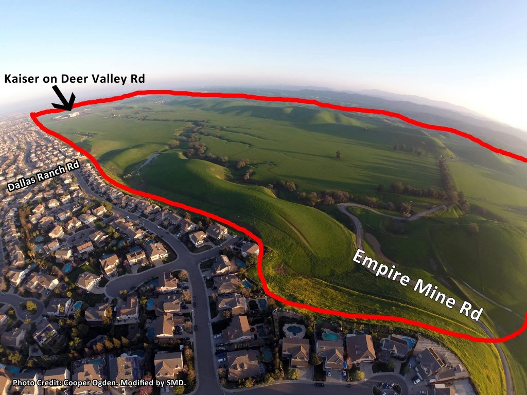
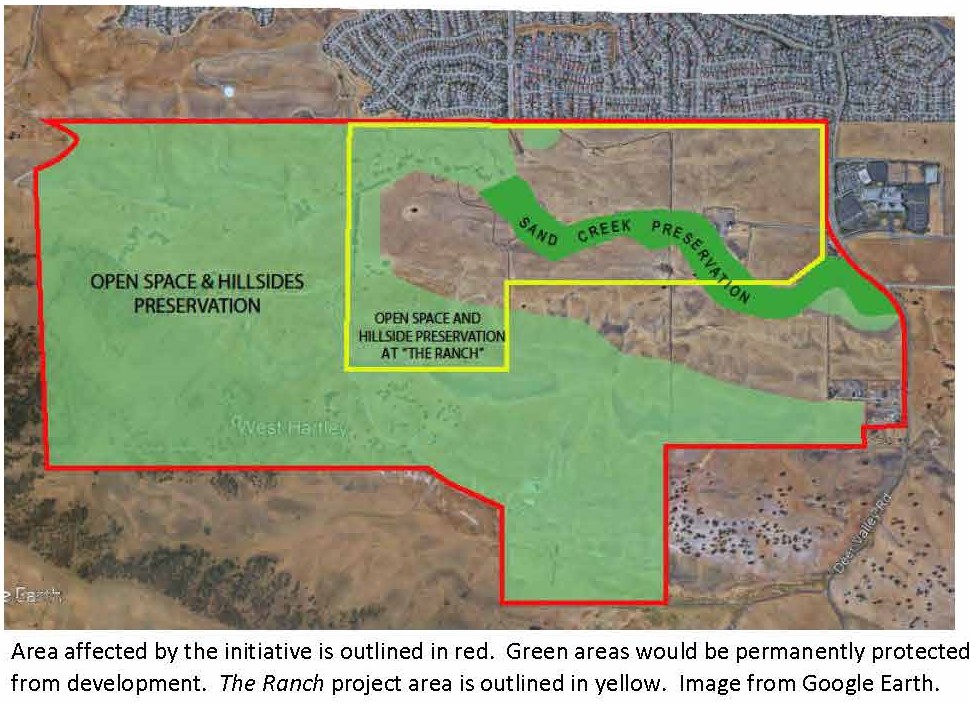
It would do so by designating the roughly 1,800-acre area between Kaiser Hospital and Black Diamond Mines for rural residential, agricultural and open space uses. It would require a vote of Antioch voters to allow more intensive development.

The effort is specifically targeting the project known as The Ranch where as many as 1,307 homes are  proposed, down from 1,700 just two years ago, as well as Zeka Ranch project, on the former Higgins Ranch property, at the western end of the valley. That property is immediately adjacent to the Black Diamond Mines Regional Preserve land, publicly owned by the East Bay Regional Parks District. – https://www.theranchantioch.com/

One project left off of the list that has yet to be approved, is the proposed development known as the Olive Groves, which includes 300 homes in a gated senior community south of Sand Creek and east of Deer Valley Road.

The initiative, if passed, would also make Antioch’s Urban Limit Line permanent. Under Measure K, through December 31, 2020, only the voters may change the location of the Line. “After that date voter approval is not required and the urban boundary can be changed by the Antioch city council any time they want. Maintaining voter approval of the urban limit line is in the best interests of Antioch residents,” the organizers claim.

Six Months to Gather Signatures

The City had 15 days from Feb. 8 to provide a title and summary before signature gathering for the initiative could begin. According to Antioch City Clerk Arne Simonsen, “the Title & Summary was prepared by the City Attorney which I received on February 23rd and immediately sent to the proponent(s) of the initiative.” Initiative Title & Summary

However, Simonsen said it is too late to get the initiative on the June ballot and the soonest it can make it would be the ballot in November.

“They have 180 days from the date they publish their Notice of Intent to Circulate Petition in the newspaper to gather the necessary signatures,” he said. That occurred on Feb. 28. The group then must print the initiative petitions and gather the necessary signatures to qualify the measure.  Published Notice of Intent 2-28-18

The group has to obtain 10% of the registered voters in the city as of the last time the County Registrar of Voters updated the California Secretary of State. That occurred early last year, according to both Simonsen and County Clerk-Registrar of Voters, Joe Canciamilla.

There were 51,040 registered voters in Antioch at that time. So, the group has to gather 5,104 valid signatures of registered Antioch voters. That will give them until sometime in late August to gather and submit the required signatures. The cut-off date to make it onto the November ballot is mid-August.

If the group is unable to make the November ballot, the soonest the initiative could be up for a vote would be in June 2020 because, according to Simonsen, “the initiative did not call for a special election, so it would have to appear on a regular election.”

Also, if the council approves the remainder of the homes prior to the November election the initiative will be moot, except for making the ULL permanent. The council could also opt to place the measure on the ballot, even if the group is unsuccessful in obtaining the required signatures or misses the deadline.

“I became involved with the ‘Let Antioch Voters Decide:  The Sand Creek Area Protection Initiative’ not only to help conserve and protect open spaces in Antioch, but also to reduce an uptick in unneeded and unwanted development and growth.  Antioch, and especially Highway 4, does not have the infrastructure to support an additional 4,000 or more houses,” said Button, an Antioch Rivertown resident who is a member of the steering committee of the “Antioch Community to Save Sand Creek” coalition. “There is so much beauty in Antioch, from the San Joaquin River to Mt. Diablo views, and we have a responsibility to ensure that this natural beauty is preserved for future generations.”

Lack of Infrastructure Capacity Claims Disputed

In response to a question about the capacity built into the design for the Highway 4 widening, Linsey Willis of the Contra Costa Transportation Authority refuted Button’s claims, stating, “The traffic studies completed as part of the required environmental reviews for the expansion of Highway 4 were based upon the housing forecast information released by the Association of Bay Area Governments (ABAG) and the Metropolitan Transportation Commission (MTC) during the late 1990’s.  The horizon year of the forecast at that time was 2025.”

In addition, Mike McGill of MMS Design, the engineer of record who designed the roads, water and sewer systems in southeast Antioch said that they were overbuilt. That was to allow for additional capacity to support the projected homes in the Sand Creek Focus Area (formerly referred to as Future Urban Area 1 or FUA-1), as well as the employment area planned for the Laurel Road area north of Highway 4 (known then as Future Urban Area 2 or FUA-2), back in the 1980’s.

“When we set up southeast Antioch, FUA-1 and FUA-2, we were doing that against the backdrop of what we were thinking the ultimate land-use would be. We put together the infrastructure for 12,000 homes in FUA-2,” he said.

“We didn’t do anything for Hwy 4, initially because we had approached Cal-Trans. They said ‘that’s a state highway, we’ll take care of that. You just bring everyone to us,’” McGill explained. “I believe they used the ultimate build-out of Antioch, Oakley and Brentwood. City staff would have given Cal-Trans that data. But, it was much more than 4,000.”

“The local network was designed to handle 12,000 units in FUA-1, now known as Sand Creek Focus Area, and Roddy,” he reiterated. “When the roads are first built, people get used to driving on them almost empty at level of service A. At ultimate build out it’s designed to be at level of service C. Lone Tree Way was designed to be three lanes in each direction without a bike lane, because the bicycles were supposed to be on the Mokelumne trail. But the bicycle coalition didn’t like that because they wanted to be on the street.”

“We had to consider the traffic coming into the area and did the traffic design for FUA-1 and FUA-2 and tied it all together,” McGill continued. “The road network was sized on the ultimate usage. But it all hasn’t been built, yet. There are pieces that aren’t done. When Sand Creek Road connects to Dallas Ranch Road the traffic on Deer Valley Road and Lone Tree Way east of Dallas Ranch Road will reduce significantly. Also, Deer Valley Road will ultimately be expanded all the way to Balfour Road.”

“With Lone Tree valley development reduced, and Roddy now gone, there will be excess capacity in the roadway than everyone originally thought and planned,” he added.

Organizations supporting the initiative.

Additional Reasons for the Initiative

Other organizers shared their concerns with the development, as well.

“For so long it has felt like Antioch has been led blindly by our city council,” said Kristina Gutilla, one of the Antioch residents who submitted the petition to the city. “This gives residents a chance to let their voices be heard, giving control back to the people.”

“Much of Antioch’s creeks, marshes, and landscapes have been paved over,” said Antioch resident Michael Amorosa, who helped create the coalition. “The extremely unique Sand Creek Area, which I like to refer to as the Upper Lone Tree Valley, is high in biodiversity and is an aesthetically alluring watershed with century old riparian forests that absolutely should not vanish in any way, shape, or form. This extraordinary slice of virgin land needs to remain as open space, not bulldozed over.”

“Antioch has a General Plan to guide development in Sand Creek. The amount of development proposed – 4,000 units – is crazy to begin with but the city has ignored the General Plan every time a project has been proposed,” said Seth Adams, Land Conservation Director for Save Mount Diablo. “If they continue at the same rate, we’re talking 4,000 to 8,000 more houses on the south edge of the city.”

However, what Adams didn’t mention is that the City’s original plans for the Sand Creek area was for 8,950 homes, plus the 640 homes at the Roddy Ranch development. Plus, the council in 2016 already approved over 1,200 homes on the eastern end of the area, between Deer Valley Road and the city’s boundary with Brentwood, around Kaiser and Dozier-Libbey Medical High School.

“Conservation of the Sand Creek Area has long been one of our goals,” said Lesley Hunt, California Native Plant Society, East Bay Chapter. “It contains several rare and unusual plants with the potential for more. It is also an important transitional zone between three major ecoregions. Preservation of this area will allow all species to adapt to changing conditions.”

Former Mayor, City Staff Respond

But, the land has been owned by developers since the mid-1990’s and is just now being prepared for development of the new, upscale homes, on larger lots, with gated communities and senior communities.

When reached for comment, former Mayor Don Freitas whose council adopted the new policies Sand Creek Focus Area in 2003 said, “It was a very transparent process. How many meetings did we have with the public? Dozens.”

“We cut the total number of homes by more than 50% from over 8,900 to about 4,000,” he continued. “We wanted the type of housing for Antioch that we don’t currently have.”

Freitas also explained how he said at the time plan had to require that the Antioch Unified School District was “100% satisfied and that there has to be enough money to build the school facilities in FUA1 or I will not support it.”

Antioch’s Community Development Director, Forrest Ebbs further stated the limit of the number of homes for the area.

“What the council did in 2003 was instead of adopting a Specific Plan for the Sand Creek Focus Area, was to adopt policies and include them in the City’s General Plan.” Those policies included the total number of homes “shall not exceed 4,000 and that has been in place since 2003,” he stated.

On the group’s Facebook page, people are encouraged to “get involved by calling Juan Pablo Galvan at Save Mount Diablo” not one of the local organizers. Galvan does not live in Antioch and only Antioch residents who are registered voters can gather signatures for the petitions.

Initiative’s Leaders Respond to Questions

The following questions were sent to Adams, Amorosa and Button on Tuesday, Feb. 20. Some of the same questions were posted on the group’s Facebook page, without response. However, Adams responded by email that day with, “Thanks for your questions.  Our coalition will respond to your email after our Steering Committee has a chance to discuss it.”

  • First, other than making the ULL permanent, why do we need another vote of the people when there have already been two to allow development in the Sand Creek Focus Area, as you point out in the press release – the Measure C countywide vote approving the original Urban Limit Line and Measure K, a vote of the people of Antioch which established the city’s Urban Limit Line in the same place?
  • Second, what city do you live in and the other leaders and most of the members of your and the other organizations helping lead this effort? Are there upscale, executive homes there in which business owners and executives live who have their businesses close by employing other residents in your cities? Why can’t Antioch have the same thing?
  • Did you try to stop that same type of housing in Brentwood, Oakley and Brentwood? Why should Antioch home owners have to move out of our city in order to live in a nicer home on a larger lot with views, or in a gated community, or in a senior community – as some of housing in The Ranch project is proposed? Why can’t Antioch have those same types of homes that other cities in Lamorinda, the San Ramon Valley and Central County have?
  • Isn’t it rather elitist and an effort to keep your property values high at the expense of those in our city, preventing us from having a complete mix of housing, now that it’s our turn to have it and we have the Highway widened, the Bypass/Hwy 4 extension will be completed, and the Antioch and Pittsburg BART Stations opened in May?
  • Also, by cutting off the additional supply of housing in our county, aren’t you contributing to the increasing home prices and rental prices, and thus to the increase in the homelessness crisis?
  • Isn’t it also contributing to actually causing people to buy homes further out in the prime agricultural land of the Central Valley and driving further to their jobs, thus blowing more smoke out of their tailpipes and polluting the environment more?
  • Isn’t 65% of the land in the county enough for open space? Plus, 900 acres of the former Roddy Ranch golf course and development have recently and in the past few years become permanent open space with the sale to the East Bay Regional Parks District, as well as acreage donated by Gordon Gravelle off of James Donlon Blvd. where he had upscale homes on view lots planned, all of which is inside the Urban Limit Line.
  • Were you aware that originally there were 8,950 homes planned for the Sand Creek Focus Area plus the 640 homes at Roddy and now it’s down to just 4,000 of which 1,200+/- have already been approved?
  • Aren’t those enough victories for you and the environmental organizations? A 58% decrease in the total number of homes?
  • Finally, it’s been mentioned that the environmental community cut a deal with the development community over Measure C and Measure J, as well, that basically said you can have the 65% of the land outside the line, but that you would leave the land inside the line alone. Is that true?

The three responded on Friday, March 2 with the following:

Frequently Asked Questions (FAQ)

What is the Sand Creek Focus Area?

It’s a 2,783 acre area along the south edge of the city, stretching from Black Diamond Mines east to Brentwood. It’s divided into three parts by Empire Mine Road and Deer Valley Road.

What Land Is Affected by the “Let Antioch Voters Decide Initiative”?

Our initiative would affect about 1850 acres from Deer Valley Road west, past Empire Mine Road, to Black Diamond Mines Regional Park. 80-90% of that area is owned by out of town speculators and developers.  Our initiative doesn’t affect the 900 acres east of Deer Valley Road including Kaiser and several already approved developments (Aviano and Promenade).

Why Is Our Coalition Proposing the Initiative?

Antioch residents are fed up.  They want change from business as usual.  Current development approvals have created many problems that need to be addressed. Additional development to the south will stretch services and damage sensitive, beautiful areas. Our initiative would require that developers persuade Antioch voters that their project benefits Antioch.

What Does The “Let Antioch Voters Decide Initiative” Do?

–      Designates 1800 acres west of Deer Valley Road as the Initiative Area and zones it Rural Residential, Agricultural and Open Space.

–      Limits development in the Sand Creek area between Kaiser Hospital and Black Diamond Mines, where the city is proposing 4000-8000 houses.

–      Require Antioch voter approval to allow more intensive development. It Lets Antioch Voters Decide if they want to allow bigger developments.

–      Permanently Require Voter Approval Of Amendments To The Urban Limit Line. The current Antioch Urban Limit Line is only voter approved until December 2020. Our measure would continue to require voter approval for changes.

How Many Signatures Do We Need To Collect?

10% of registered voters in Antioch, or 5100.  But some won’t be good signatures, so our goal is 7700 signatures. We’re starting collecting March 3-4.  To qualify an initiative you have 6 months but we hope to finish sooner.

How Can I Help?

–      We need help collecting signatures to qualify our initiative. It’s easy, we’ll put you with a partner or you can bring your own, and a shift is just two hours.

–      Check our Coalition Facebook page: “Antioch Community to Save Sand Creek” or call or email Juan Pablo Galvan at Save Mount Diablo at 925 947-3535 or JPGalvan@savemountdiablo.org, to sign up.  www.facebook.com/antiochsavesandcreekandstoptheranch/

–      Like and Share our Facebook page – it’s the easiest way to communicate with you.

–      Sign up for our E-Blast – it’s our most detailed information.

What’s Special About The Initiative Area’s 1850 acres

From A Neighbor Perspective: It’s beautiful, and if our initiative is adopted, it doesn’t stretch services, it doesn’t add traffic, etc.   From A Resource Perspective: The Initiative Area is beautiful ranch land and open space next to Black Diamond Mines and Deer Valley Regional Parks.  It’s crossed by sinuous Sand Creek, which supports a number of endangered species, and is part of a wildlife corridor from Black Diamond Mines to Los Vaqueros Watershed. It’s home to many rare plants and animals, including golden eagles and owls, as well as more common species like bobcats, deer and coyotes. It’s the most sensitive part of the Sand Creek Focus Area with big rock outcroppings, ponds, and springs and an oak savannah with huge old oaks separating the Sand Creek Area from Horse Valley and Deer Valley Regional Park. It’s also a bad place for development with underlying coal mines – two coal mining towns were located in the Focus Area. The real question is whether to impact the public’s investment on these parks, or to buffer the parks.

Do We Need More Housing?

Not For Years.  Antioch already has over 2000 housing units in town approved but not built. That’s a huge amount of traffic and impacts on schools, police, fire and other services that are yet to be felt.

What Is An Initiative?

“Initiatives” are one of the reforms from the Progressive Area, like “recall” of corrupt politicians.  It allows private citizens to write and enact their own laws. After talking with people for over two years, that’s what we did, with the help of a volunteer, retired law professor.

Do We Need This Initiative Now If Development Might Not Happen For Years

Yes. If the area west of Kaiser isn’t protected by our initiative, it will be broken up and fragmented by current development applications, even if development takes place later.  The area east of the hospital has already been fragmented.  Developers and some elected officials like to suggest impacts of projects might not happen for years. But they also suggest project benefits will happen immediately. Reality is in the middle. They also ignore that other development already approved, but not yet built (more than 2,000 units in Antioch) is still to be felt in our schools and services. Approving more development when thousands of units are already approved Is asking for problems and digging those holes deeper.

What Are “Development Agreements” ?

Developers ask the city for “Development Agreements” which guarantee their rights for extended periods.  In many places, those “Development Agreements” rights are negotiated in exchange for substantial public benefit. In East County they’re practically given away.

There Have Been Several Votes On Urban Limit Lines (ULL), Why Do We Need Another?

There have been five major urban limit line decisions affecting Antioch in 30 years. They’re all listed at the bottom of this FAQ.  Most of them were very general and don’t affect any of the properties in the Sand Creek area.

Why Didn’t You just Shrink the Urban Limit Line (ULL) to Exclude the Sand Creek Area?

If our initiative qualifies and is approved by the voters, Antioch voters retain control of the area. Developers will have to convince Antioch voters to allow more intensive projects. If we had proposed shrinking the ULL, the city and developers would probably threaten that the area would be developed by the County or Brentwood. Our initiative would maintain local control by Antioch residents.

Who Are We? Are Antioch Residents Involved?

Developers or elected officials sometimes try to suggest that newer residents, nonresidents, or advocacy organizations should be ignored or aren’t legitimate.  They never make that claim about out-of-town developers. More than 80% of the area that would be affected by our initiative is owned by 4 out-of-town developer speculators, including two from Southern California and one from Nevada.

We believe anyone who lives, works, or plays in Antioch has a voice. These projects threaten existing neighborhoods and residents’ quality of life. They also threaten two regional parks we’ve all invested in, wildlife and resources, and will have regional impacts on traffic, air quality, etc.  Just because you’re a new resident doesn’t mean your voice is less important. The real question is whether new development will stretch services and make problems worse, or better?

The “Antioch Community to Save Sand Creek” coalition which drafted the initiative, is made up of Antioch residents and community groups, and communicates with thousands of Antioch residents.  All three of the listed proponents who drafted the initiative—Michael Amorosa, Selina Button, and Kristina Gutilla– are Antioch residents. Community groups such as Save Mount Diablo, Greenbelt Alliance, California Native Plant Society, and Sierra Club all have members who live in Antioch.

How Much Traffic Would The Sand Creek Focus Area Cause?

Each new house generates 10 daily car trips, according to traffic engineers. 4,000-8,000 housing units would generate 40,000 to 80,000 car trips per day, on Empire Mine Road, Dallas Ranch, and Deer Valley Road, through existing neighborhoods to Lone Tree Way, without increasing capacity on any roads.  Our initiative does not affect any road extensions, or completion of Sand Creek Road from the Bypass to Deer Valley Road and Kaiser.

How Will Sand Creek Development Affect Our Local Economy?

Since there are already thousands of houses approved to be built in and Around Antioch, this development isn’t needed to create temporary building jobs. The proposed development will compete with existing and already approved but not yet built housing, reducing property and resale values.

Where Are The Developers Going To Get Water?

The developers do not provide any new water supplies, further stretching our water supplies during drought.

Why Didn’t You Include The Area East Of Deer Valley Road In The Initiative?

Our initiative is silent about the area east of Deer Valley Road and wouldn’t change the status quo.  Just like it’s silent on other areas. One reason is that area is already fragmented and includes Kaiser and two approved housing projects, Aviano and Promenade. They’re grandfathered in. City officials say they want Senior and Executive Housing. There is a proposed senior project there, the 301-unit “Albers Ranch / the Olive Groves” project (If the city actually makes them perform on promised senior housing.)

Why Did you Exclude the small 4-acre rectangle at the bottom right corner of the initiative area?

There’s only one parcel west of Deer Valley Road mentioned in the city’s General Plan Housing Element.  It’s that 4-acre property. None of the other parcels

The City Wants Upscale, Executive, Senior Housing or Business Park, etc.

At about 115,000 people, Antioch is almost tied with Concord for largest city in the County by population. It’s nearly tied for second with Concord in geographic size. It’s a little late to think it’s an underdog.  If it doesn’t have what other cities have it’s because the city council is not demanding it, or developers don’t believe the market will support it.

Is This The Place For Executive Housing

“Executive Housing” is a buzz word meant to suggest “upscale” and is often demanded or promised, but rarely delivered. Executives tend to live close to business parks and headquarters, like Bishop Ranch, Hacienda, and in Silicon Valley or San Francisco.  Until the city solves existing problems, businesses are less likely to locate here.  Developers claim they will build Executive Housing to get approvals.  Then they ask the city to let them build whatever the market will bear at the time of construction. The Antioch City Council usually allows them to change their product whenever they ask. So, one thing gets approved, then what actually gets built is different.

Is This The Place For Senior Housing?

We’re all aging, and many of us have aging parents, so Senior Housing sounds good, but it’s rarely delivered. Cities often suggest they want senior housing because it suggests less commute traffic and no impacts on schools.  Then after environmental review is done, they often discard the senior requirement and you get those traffic and school impacts anyway.  That’s exactly what’s happening at the Aviano project, east of Kaiser.

Are Our Organizations Working Just In Antioch?

The organizations involved in our coalition have all been working in East County for decades, in a variety of cities, on a variety of projects. Save Mount Diablo for example, began working to create Black Diamond Mines Regional Park in 1973

What Does The Sand Creek Area Have to Do With Mt. Diablo?

The Sand Creek Area is part of the foothills of Mt. Diablo, a wildlife corridor from Black Diamond Mines to Los Vaqueros Watershed, and adjacent to two regional parks Save Mount Diablo helped create, Black Diamond Mines and Deer Valley Regional Park. It’s part of the historic Mt. Diablo Coalfields which began being mined in the 1850s. And the area is part of the Diablo Range, which was defined by the California Geological Survey in the 1850s.

Why is a staff member for Save Mount Diablo, the contact for the effort?

Because this is a big priority for Save Mount Diablo and to make it easy for people asking questions to reach us.  Check our Coalition Facebook page: “Antioch Community to Save Sand Creek” or call or email Juan Pablo Galvan at Save Mount Diablo at 925 947-3535 or JPGalvan@savemountdiablo.org, if you have questions.  www.facebook.com/antiochsavesandcreekandstoptheranch/

Should We Be Concerned About Our Property Values?

Of course Antioch residents should be concerned about our property values. For many families, it’s our major investment. During the recession, many Antioch houses lost half their values.  Every new house that’s built competes with existing houses for resales. Caring about property values and quality of life is common sense.

Does Requiring Developers to “Let Antioch Voters Decide” Restrict Housing Supply?

No. It Requires Developers to Propose Projects Good Enough to Get Voter Support.  There are thousands of homes approved but not yet built in East County, including more than 2,000 in Antioch. Every City is required to meet regional housing needs by zoning adequate land for housing.  Antioch has zoned and approved more than required. Not a single parcel in our initiative area is required to meet Antioch’s designated housing needs.

If They Don’t Build It Here, Won’t They Build it On Prime Farmland Further Out?

California has had massive waves of development since the Gold Rush. As long as there’s good weather and a strong economy, it will continue. Antioch has more than met its share of regional housing. Residents have the right to preserve their community’s quality of life.  Whether we make better development choices now or after there is no more vacant land in Antioch, we face the same choice—smarter growth with fewer impacts. Plenty of communities are building lots of housing without spreading out further.

How Did You Calculate 4,000-8,000 House Number In The Sand Creek Focus Area ?

The City’s General Plan suggests 4000 units in the Sand Creek Area, but for each project so far they’ve amended the General Plan to allowed more. The Sand Creek Focus Area includes 2,783 acres. The approved Aviano and Promenade projects include 1,183 houses on 281 acres east of Kaiser.  “The Ranch” proposes 1307 on 552 acres.  “Olive Grove” proposes 301 units on 97 acres.  In total that’s 2,791 units on 930 acres, just a third of the total acreage.  If the city continues ignoring the General Plan at the same pace, that equals 8,352 units on 2,783 acres.  So we use a range of 4000 units suggested in the General Plan and 8000, suggested by what’s actually taking place.

What Planning Has Happened In The Sand Creek Area?

Antioch started but never finished a Specific Plan in the Sand Creek Focus Area (2002-2003) and started but never completed a General Plan Amendment of the 2003 General Plan. The only real land use map is a 2018 photocopy of a 2003 photocopy (below), with a couple of changes on the east end. That’s the level of planning for this area.

Both the 2003 and the 2018 Antioch General Plans say:  “Prior to or concurrent with approvals of any development applications other than major employment-generating uses (including, but not limited to a medical facility on the Kaiser property), a specific plan or alternative planning process as determined by the City Council, shall be prepared and approved for the Sand Creek Focus Area.”

The City has never completed a Sand Creek Specific Plan. Instead, a developer proposes a project and the city ignores its vague General Plan Focus Area map, and approves something completely different.

The Sand Creek area was originally called Future Urban Area #1 (FUA#1) and was added to the city in the early 1990s. Around 2002 the city began planning a specific plan for FUA#1. They did inadequate environmental review and when challenged by environmental groups, they tabled the specific plan and never completed it. The only direction about the Sand Creek Focus Area is a few pages in the General Plan, (GP 2003, pg 4-38 to 4-45) and a version of the vague map above, (http://www.ci.antioch.ca.us/CityGov/CommDev/PlanningDivision/docs/Antioch_Adopted_General_Plan.pdf).

In 2003 the City updated the General Plan and included a document that had been developed for the FUA#1  Specific Plan that was never finished, called “Appendix A: Sand Creek Resource Management Plan.” In 2015-2018 the city started to create something like a Specific Plan (a General Plan Amendment) again for the Sand Creek Focus Area as part of a General Plan Update.

Once again they did inadequate environmental review and when challenged by environmental groups, they tabled the plan again and never incorporated it into the General Plan. Bottom Line, the City has started to create a Specific Plan for the Sand Creek Area twice, and never completed either Plan.

Does The Current Specific Plan Or General Plan Protect The Creek?

No.  There is no Specific Plan for the area.  The General Plan has some vague language but no specific setbacks from the creek. A Management Plan attached to the General Plan refers to the draft Specific Plan that was never completed and a 250’ creek corridor. And for all 3 projects so far, the city has changed the General Plan substantially.  Save Mount Diablo was successful in getting a significant creek buffer for the Aviano and Promenade projects, but nothing in the General Plan requires it. The “Let Antioch Voters Decide Initiative” requires a 200’ wide corridor on either side of Sand Creek if approved (400’ total).

Editor’s Note: However, according to Ebbs, The General Plan has language providing appropriate buffers for development adjacent to Sand Creek. There’s no numerical standard. It’s based on a site-specific analysis because the creek varies and the projects vary. So, there’s not a standard, across-the-board set-back. There is a host of other agencies that review this, that have their standards. But, the plan does not say you can build right up to the creek, by right.

Urban Limit Line Decisions Affecting the Antioch Area

Nov. 1990 – Measure C –  County Urban Limit Line (ULL) was approved, creating – it was expansive and designed to allow a large amount of development. Cities weren’t bound by the ULL, which could be changed by a 4/5 vote of the County Board of Supervisors.

Aug. 2000 – County Urban Limit Line Tightened – The County Board of Supervisors approves tightening the County Urban Limit Line. It still only affects the County.

Nov 2004 – Measure J – Requiring Voter-Approved Urban Limit Lines – The Contra Costa Transportation Authority passes Measure J, requiring that the County and all the cities have voter-approved Urban Limit Lines to qualify for transportation funding.

Nov. 2005 – Measure K Roddy Ranch Developer Urban Limit Line – in response to Measure J, Roddy Ranch/developers circulate Measure K, an expansive Urban Limit Line affecting just Antioch – potentially allowing a large amount of development. The campaign is all about limiting growth but in reality Measure K could allow a lot of development. The measure is approved. It will sunset in Dec 2020, after which point voter approval is no longer needed to change it. At that point it can be changed by the Antioch City Council.

Nov. 2006 – Measure L Unified County Urban Limit Line – in response to 2004 Measure J, the county Board of Supervisors places Measure L on the ballot, referencing the 2000 tightened Urban Limit Line, and various changes all around the County. (Editor’s Note: Measure L did not make any changes to the Urban Limit Line in Antioch).

What’s the 65/35 Plan? Was it an agreement with Environmentalists?

No it wasn’t.  In 1990 Conservationists proposed the first County Urban Limit Line Measure, Measure F. The County Board of Supervisors and Developers put a competing Initiative on the ballot, Measure C (see above).  Measure C beat Measure F and created an expansive County Urban Limit Line called the 65/35 plan.  Developers said “Who cares if there’s an Urban Limit Line if you need binoculars to see it?”

Problem was, Measure C didn’t affect cities. If developers couldn’t get what they wanted from a city, they’d go to the county, and vice versa.  Measure C could also be changed by a 4/5 vote of the County Board of Supervisors.

Isn’t There 65% Open Space Outside The Urban Limit Line, And 35% Inside the Urban Limit Line?

No. The 65% standard just suggests non-urban density. That can include all kinds of development like all the houses along Marsh Creek Road, the trailer park, the county jail, etc.  The 35% standard is urban, but it can also include all kinds of other uses including protected land.  There’s protected land inside the line, and developed land outside the line.  In Antioch for example, Contra Loma Reservoir, Dow Wetlands and part of Deer Valley Regional Park are all inside the Urban Limit Line and the City Limits, and are protected.

The line became more useful when it was tightened by the County Board of Supervisors in 2000, and even more so in 2004 when Measure J required that both the county and the cities have voter-approved Urban Limit Lines—that put more control in the hands of residents.

More Information

General Plan:  A statement of policies, including text, maps and diagrams setting forth objectives, principles, standards, and plan proposals, for the future physical development of a city or county. The official public document or ‘constitution’ adopted by a county, city or other agency as the policy guide for decisions about its future development and redevelopment. A General Plan usually includes, but is not limited to, a land use plan, housing, transportation, etc.  General Plans and General Plan Amendments and are subject to environmental review.

General Plan Amendment:  An amendment to the General Plan can involve either a change to the policy text of the plan or a change on the General Plan Map which alters the land use designation of a particular parcel of property. General Plan Amendments and are subject to environmental review.  The 1300(-home) “The Ranch” project would require a General Plan Amedment.

Specific Plan: A plan addressing land use distribution, open space availability, infrastructure, and infrastructure financing for a portion of the community. Specific plans put the provisions of the local general plan into action. For example, a “Downtown Specific Plan” or the “Sand Creek Specific Plan” covering a smaller part of the city.

Urban Limit Line: The local government enacts an ordinance that defines on a map where growth will occur in the future and where basic services, such as schools, sewers, water facilities, and police and fire protection, can be provided economically.  AKA “Urban Growth Boundary (UGB).” Each one is unique. Some are strong. Some are weak.

Adams also responded to the questions directed to him with, The leaders of community organizations also represented on the Steering Committee are from a variety of places; all of those organizations have members and donors in Antioch. I personally live in Martinez. All of the developers proposing projects in the initiative area are from out of town or out of state.

The initiative isn’t about stopping all development, or any specific kind of development – it’s about giving control to Antioch voters,” he added. Caring about quality of life and property values is common sense.

The group filed the necessary paperwork with the Antioch City Clerk’s office on Thursday, March 1 in order to begin raising funds to pay for the campaign. Form 410 Initial Antioch Community to Save Sand Creek rcvd 3-1-18


Joy Motts switches sights and files intent to run for Antioch City Council in November

Saturday, February 24th, 2018

Joy Motts from Facebook on Oct. 31, 2017. Photo by the Hon. Monica Wilson

By Allen Payton

After serving on the Antioch School Board and running unsuccessfully for reelection in 2014 and then again in 2016, on Tuesday, Feb. 13, Joy Motts switched her sights toward the City Council and filed an intent to run in the November election. She is the first candidate to do so and will either face one of the incumbents Tony Tiscareno or Lori Ogorchock, if either decides to run for reelection or are able to should they live in one of the new districts that will be soon be created by the council. Form 501 – Joyann Motts filed 2-13-18 (1)

Motts served on the school board from 2010 to 2014. She has since been leading the effort to create a park and event center, named the Rivertown Square, on the former Antioch Lumber Company lot in downtown, also known as The Yard. Two efforts by the group to place an initiative on the ballot have failed. But, the council recently rezoned the property to mixed use which would allow the park and event center.

Motts is also one of the directors of the Celebrate Antioch Foundation which organizes Antioch’s annual July 4th Parade and Celebration, as well as the Holiday Parade and City Christmas Tree Lighting. She is also a member of the Rivertown Preservation Society, a group of homeowners seeking to preserve the historic qualities of the city’s downtown, north of W. 10th Street.

Filing for the two council seats up for election in November opens in July. However, neither Motts nor anyone else knows, yet if she will be able to run this year. She lives in the Rivertown area but, if and until the council approves dividing the city into four districts, the two that will have elections this year won’t be known until their meeting on April 10.

Asked why she wanted to run for the city council, Motts responded with the following via email:

“To start, service for my community is a part of my DNA.  My parents believed and instilled in myself and my siblings that it was a citizen’s responsibility to participate in making and leaving the world a better place. My father served our nation in World War II and my mother, served 20 years on the Antioch School Board.  I followed in her footsteps and served on Antioch’s School Board between 2010 and 2014, and I am proud of the work that was accomplished during that time, from being fiscally efficient and successfully weathering the economic downturn to the rebuild and renovation of Antioch High School.  I serve and still work on several Foundations and service organizations that support Antioch’s children, its quality of life and its citizens.

As a lifelong resident, it has been frustrating to watch surrounding communities thrive while Antioch continues to struggle with issues of crime, blight and homelessness.   Whereas recently I have seen improvements, we are still a community that needs a stronger and cohesive vision, and leadership that can collaborate on a brighter path forward. The perception that we are not a healthy or safe community, that our schools are failing is sometimes played out on social media, our local news and in the conversations amongst ourselves and all over the Bay Area and makes economic vibrancy very difficult. This should not be our story.  It is time for Antioch to recognize its potential!  We sit in a beautiful place, with unparalleled climate, on the San Joaquin Delta, one of the largest inland waterways in the world, in the middle of the State that has the seventh largest economy in the world. We are diverse, intelligent and are home to citizens with some of the highest salaries in the Bay Area.

As a city councilwoman, I plan to tackle those issues that are preventing us from changing our story.  We must maintain and improve the number of police that protect this great city. We must support the extension of Measure C to support law enforcement and all efforts to keep our citizens safe. We need Code Enforcement to return to pre-recession employee levels to tackle the negligent and irresponsible landlords and business owners who do not maintain their properties or shopping centers and all areas of blight in our community.  We must develop a long-term plan to support the rehabilitation, support of services and housing for homeless.

We must work together with the Antioch Unified School District as over 20,000 of our citizens attend Antioch schools, private and public as AUSD is our largest employer, their concerns and challenges are and should be the City of Antioch’s concerns and challenges.  We need to develop a strategic plan to address infrastructure needs for our entire city especially our older north Antioch community. We must work with other cities in the Bay area and aggressively promote job development in East County and along Antioch’s northern waterfront, a gold mine of possibility for good living wage jobs for our citizens.

We must sit down with our community, developers and other interests, in collaborating on what smart growth and development looks like before we end up at a stalemate.  We must listen to our citizens, promote community and civic events and create reasons for our community to come together to celebrate.  I am committed, passionate and capable of making a difference.  Hope this helps you understand why I am running.”

On Thursday, Feb. 22 Motts filed paperwork for the formation of her campaign committee, Citizens for Joy Motts – 2018 City Council, allowing her to begin raising receiving contributions. Form 410 – Citizens For Joy Motts – 2018 City Council rcvd 2-22-18

For more information about the city’s districting process, click here. For information about running for city council, contact the City Clerk’s office at (925) 779-7009.

Not all residents happy with council dividing Antioch into four election districts, “not a done deal”

Wednesday, February 14th, 2018

How should the City Council divide Antioch into four equal districts? Create your own map and offer your input now through April 10.

Next hearing Thursday night, Feb. 15 at 7:00 p.m. at Antioch Community Center in Prewett Park

By John Crowder

The City of Antioch held it’s first of two public hearings on Districting on Tuesday, February 13 and not all residents are happy about it. Districting is the process that may result in changing from the current system of at-large elections for city council members to one in which representatives are elected from four districts, by voters who live in each district. (See related articles, here and here).

When the agenda item was reached, late in the meeting, Interim Antioch City Attorney Derek Cole explained the process

According to Cole, it was the first of five meetings the City would undertake as part of the process to convert from at-large elections of City Council members to elections held by District. However, the mayor would still be elected citywide under the new system. Cole introduced Karin MacDonald, Principal Consultant of Q2 Data and Research, the consulting firm tasked with leading the districting process for the city. Q2 was the same firm selected as the consultant to the California Citizens Redistricting Commission for the statewide decennial effort in 2011.

MacDonald provided a slide presentation explaining the districting process.  As she explained, the 2001 California Voting Rights Act (CVRA) made it easier for members of a protected class to prove that at-large elections ‘dilute’ their voting strength.  In November 2017, the Council received a ‘demand letter’ asserting a violation under the CVRA.  As a result, in January 2018, the Council passed a resolution of intent to move from at-large to by-district elections.

According to MacDonald, the strict timeline and constraints imposed by the CVRA require the entire process be completed in 90 days, that five hearings take place, and that two of these hearings occur prior to creating a draft map.  At the final hearing, the Council can adopt the Council District Boundaries.

Besides explaining the process, the February 13 hearing would serve as the first of two hearings designed to gather community input.  The second will take place on February 15, at 7:00 pm, at the Prewett Community Center.

The third meeting is scheduled for March 10, at 9:00 am at the Nick Rodriguez Community Center.  During that meeeting, consultants will present the input received and outline draft maps and options.  The Council will be able to create a draft map during the meeting.  The draft map will be available for comment online and elsewhere around March 12.

The final two meetings will be held on March 27 and April 10, both at 7:00 pm in the City Hall Council Chambers.  At these hearings the ordinance will be read.  At the final hearing, it is anticipated that a vote will take place on the ordinance.

MacDonald noted that there are five criteria used for drawing districts; equal population, compliance with the Federal Voting Rights Act (FVRA), contiguity, compactness, and respect for communities of interest.  Not to be considered are incumbents, candidates, and political parties.  Elections could be undertaken by districts as early as November 2018.

During the hearing, a handful of speakers weighed in, some supporting and some opposing the idea of district elections.

Nancy Fernandez, the first speaker, stated her opposition to district elections.  “They don’t function because each council member is trying to please his voting constituents and not doing the business of the city as a whole,” she said.

Planning Commissioner Jim Conley also spoke in opposition.  After stating that Antioch has a diverse community and a diverse city council, he said that districting makes council members very parochial and leads to backroom deals being done.  “The City doesn’t matter,” he said, “It’s your district that matters.”

Planning Commissioner Kerry Motts expressed support for district elections.  He said that districts have worked elsewhere and will solve a major problem of underrepresentation in the northern part of Antioch.

Two members of the East County Regional Group spoke in favor of district elections.  They argued that district elections would make running for office more accessible, and asked that the number of immigrants, low-income, families, and people of color be considered in forming districts.

Representing the Rivertown Preservation Society, Joy Motts also spoke in favor of district elections.  She said that members of the Rivertown community do not feel they are represented or listened to and said that the creation of a path for a North Rivertown representative should be a priority.  She dismissed the idea that elected officials would be parochial, saying, “Quality leaders will work together.”

The last to speak from the public was long-time resident Larry Harrison.  Calling the move to district elections, “utter nonsense,” he said that it was, “a solution without a problem.”  He advocated banding together with other cities that oppose moving to district elections and working to overturn the law that was forcing the change.

During Council discussion, Mayor Pro Tem Lamar Thorpe began by saying, “This is not a done deal.”  He went on to say that, while the Antioch City Council is diverse, other elected offices must be considered, and other factors besides race should be taken into account.  (Mac Donald responded that race could not be considered in drawing districts.)  Thorpe also said that the process had created more competitive elections in other electoral races.

Council Member Tony Tiscareno noted that the demand letter was based on lack of Latino representation, yet, “we have Latino’s living throughout the city.”  He also raised the concern that data from the 2010 census would be used to draw the maps.  “Right now, it’s very confusing to me,” he said.

Mayor Sean Wright agreed with Tiscareno that the process, and the premise behind it, were confusing.  “The confusion for all of us, is that we’re threatened because we’re ‘racially polarized.’  It just does not make sense,” he said.

Council Member Lori Ogorchock expressed concern with the lack of attendance.  “There’s maybe forty people here,” she said.  “We really need to hear everybody’s point of view.  We want everybody to have their voices heard.”  She encouraged those present to share information with their neighbors.

Following the hearing, the lead consultant, Ms. MacDonald, emphasized the need for as much public input as possible to create, “lines that will work.”  She asked that City residents go to the City Website and to the Districting page, http://districtelections.ci.antioch.ca.us/, and share their comments and even create their own draft maps using the interactive city map.