Archive for the ‘News’ Category

Highway 4 Night Closure at Somersville Starts Aug. 15

Tuesday, August 9th, 2011

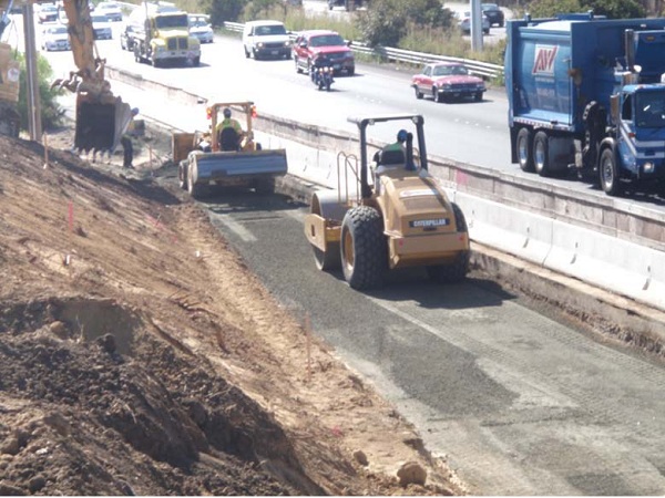
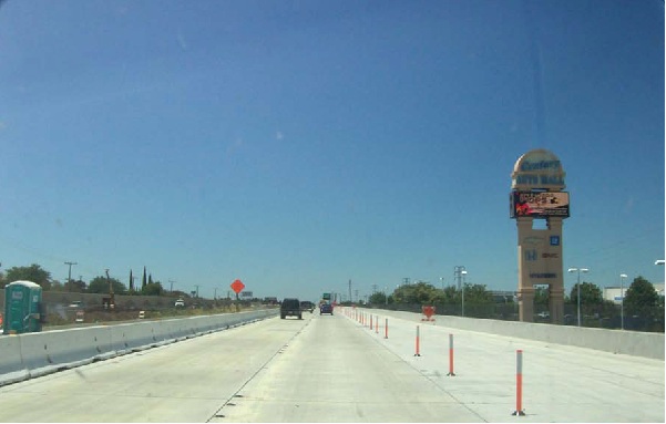
The contractor for the Somersville Road project will be closing all northbound and southbound lanes of Somersville Road where it crosses under Highway 4 beginning on August 15. This closure will be in place from 11 p.m. to 6 a.m. on Monday through Thursday nights and from 11:00 p.m. to 7:00 a.m. on Friday nights.

It is estimated that the work will take three weeks to complete. The anticipated completion date is September 2. This closure is to ensure crew and public safety while crews install temporary supports for construction of one of the new bridges at Somersville Road. Signs will be in place directing motorists around the work zone via Delta Fair Boulevard and Century Boulevard.

Motorists are advised to expect delays and allow extra time for their commute. Please drive with caution through the detour and leave a safe traveling distance between your vehicle and the vehicle ahead of you. Caltrans and CCTA appreciate your patience as we work to improve the highways. For the most current information on all SR-4 corridor projects and lane closures please visit our web site at: http://widensr4.org.

Highway 4 Closure Friday Night

Tuesday, August 2nd, 2011

The contractor for the Highway 4 widening Loveridge Road project will close all lanes on westbound Highway 4 at Loveridge Road for several hours on Friday between 11 p.m. and 5 a.m. This work is to ensure public and crew safety while crews work to place steel piles for the bridge structure at Loveridge Road.

The detour for this work will be as follows: motorists will be directed off the highway at Somersville Road/Auto Center Drive, left on Somersville Road, continue on to Auto Center Drive, left on Tenth Street, left on Loveridge Road, right on California Avenue, and left on westbound Highway 4. Motorists are advised to expect delays and allow extra time for their commute.

Please drive with caution through the detour and leave a safe traveling distance between your vehicle and the vehicle ahead of you. Caltrans and CCTA appreciate your patience as they work to improve the highways. For the most current information on all Highway 4 corridor closures please visit http://widensr4.org.

New Redistricting Maps Mean Changes for Antioch in Assembly and Congress

Saturday, July 30th, 2011

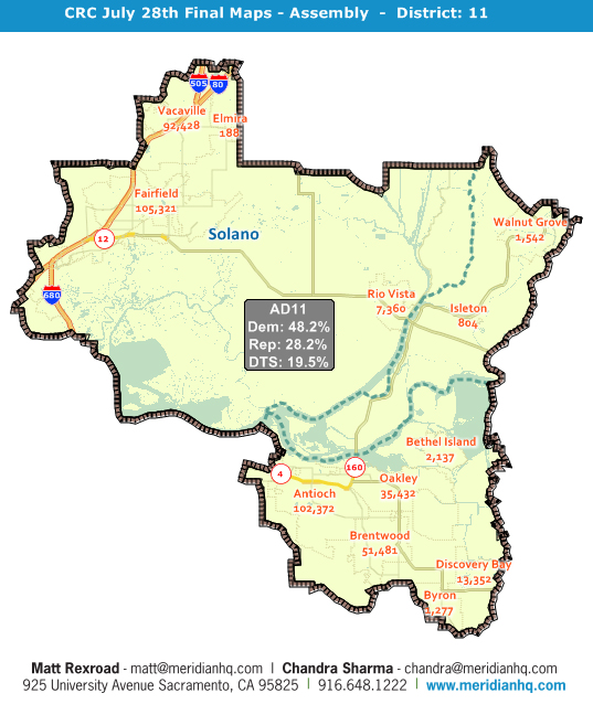
The new Assembly District 11. Map and information by Meridian Pacific, Inc.

By Allen Payton, Publisher

The California Citizens Redistricting Commission took their first vote on the final maps for State Assembly, State Senate, Congressional and Board of Equalization district maps, yesterday, Friday, July 29 and the results mean many changes for Antioch.

STATE ASSEMBLY

All of Antioch will now be in a new Assembly district, labeled AD11, with the other East County communities of Oakley, Brentwood, Discovery Bay, Bethel Island, Byron, Knightsen and part of Pittsburg, as well as the majority of Solano County. The city will no longer be represented by Susan Bonilla (D-Concord) and will get a new Assembly member, since there is no incumbent who currently lives in the new district. A member of either the Assembly or State Senate must live in the district they represent.

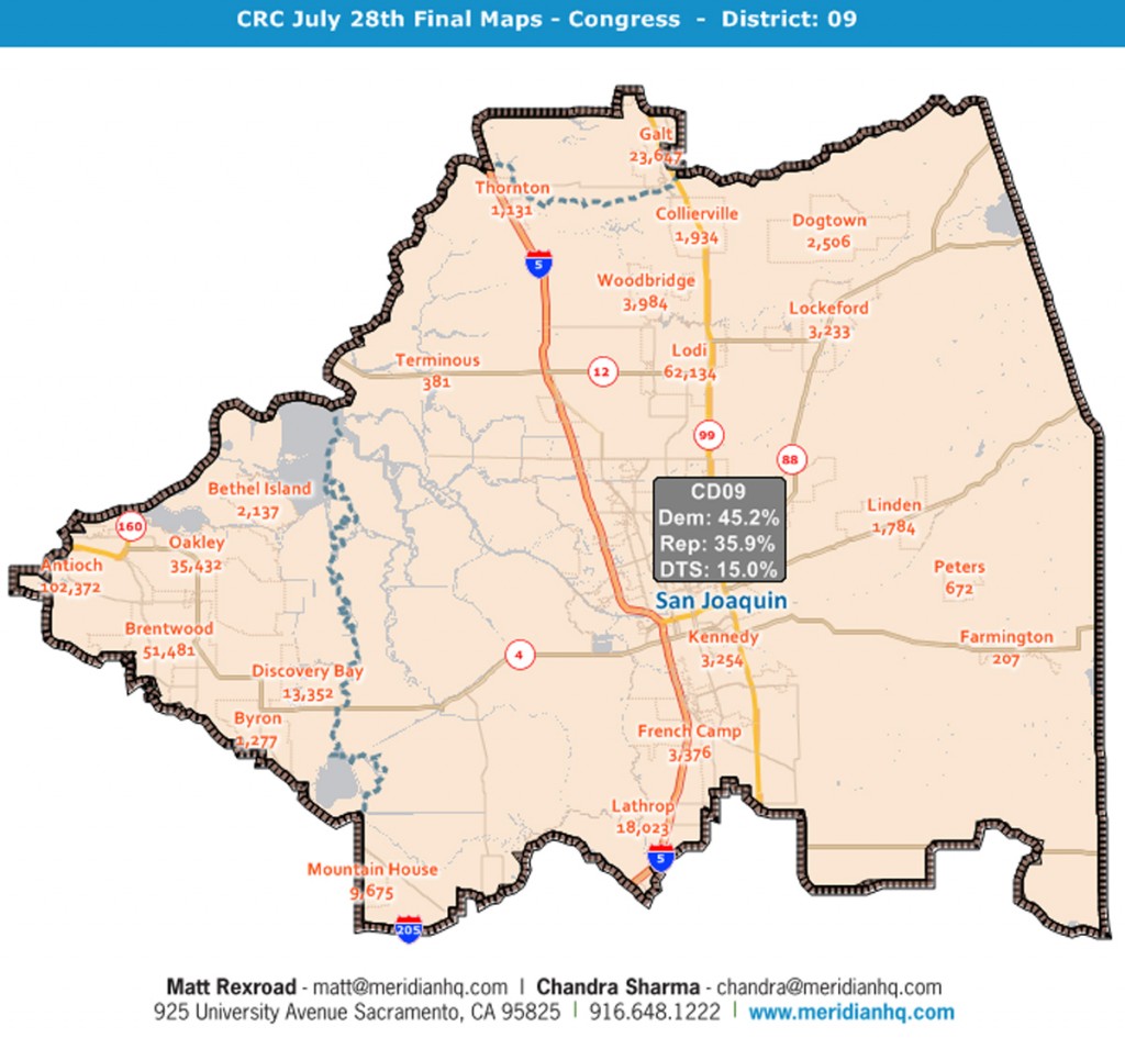
The new Congressional District 9. Map and information by Meridian Pacific, Inc.

CONGRESS

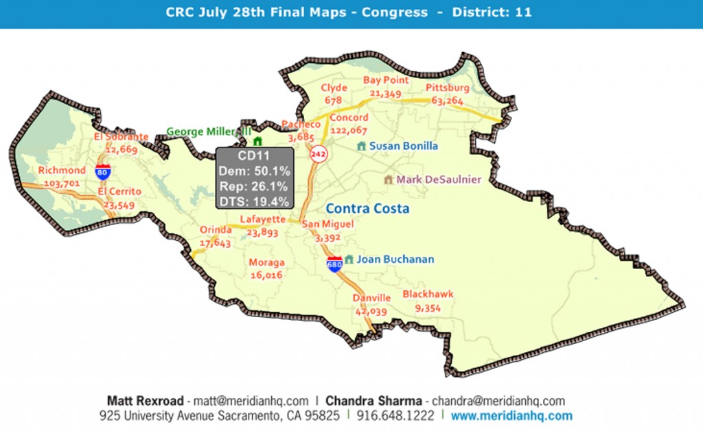
Antioch will also be getting two new members in the House of Representatives, with the western side of the city moving into Congressman George Miller’s (D-Martinez) district and the rest of the city into a district with no incumbent. However, Congressman Jerry McNerney (D-Pleasanton), who currently represents a portion of  San Joaquin County and Eastern Contra Costa County, announced he will be moving into the new district in San Joaquin County, although that’s not a requirement for Congress.

The new congressional district maps divide Antioch in a peculiar way, because each congressional district has to be equal in population, unlike State Assembly and Senate Districts, which have an approximate one percent population deviation from one to the other.

The new district line runs from Somersville Road, south of the James Donlon Blvd. intersection, down the middle of James Donlon Blvd., includes the Twin Creeks Apartments and then turns north down the middle of Contra Loma Blvd. Then the line runs along Putnam Street, then turns north along D Street to San Joaquin Avenue.  It turns east to West Tregallas Road, follows that road around the Post Office back to D Street, then heads north to the west bound lanes of Highway 4.

The new Congressional District 11, including western Antioch. Map and information by Meridian Pacific, Inc.

It then runs east to A Street, turns north and runs in the middle of A Street to 18th Street. The dividing line then turns west and runs along 18th Street to D Street, again, turns north to 10th Street. It then makes a right turn and heads one block east along 10th Street to C Street, then south on C Street to Park Lane.

It then runs east on Park Lane back to A Street where it turns north and runs up to Beede Way, turning east, briefly to Almond Court, to Wilbur Avenue. It then turns east and runs down the middle of Wilbur Avenue to Fulton Shipyard Road. It turns north and runs along Fulton Shipyard Road to just east of the old shipyard and runs north out into the river.

In general, if you live on the northwest side of the dividing line, you’re in CD11 with the smaller portion of Antioch, all of Pittsburg, Bay Point, and most of the rest of Contra Costa County, and Eastern Alameda County. If you live on the southeast side of the line, you’re in CD9 with most of Antioch, Far East County and northern San Joaquin County.

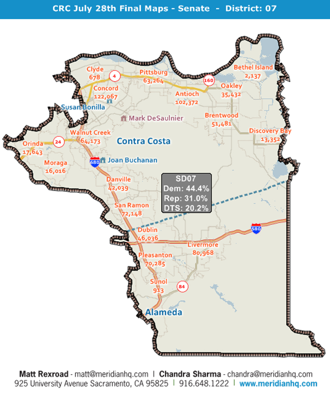
The new State Senate District 7. Map and information by Meridian Pacific, Inc.

STATE SENATE

State Senator Mark DeSaulnier (D-Concord) will continue to represent Antioch and the rest of East County, as well as most of Contra Costa County, plus Dublin, Pleasanton, Livermore and Sunol in Eastern Alameda County, in State Senate District 9. Finishing his first term in the State Senate, he is up for election, next year and can run for only one more term.

For more information and to see all the maps of all the 177 new districts throughout the state, click here or visit either www.wedrawthelines.com or Meridian Pacific’s website at www.mpimaps.com/mapanalysis.

Highway 4 Closure Monday Night

Thursday, July 28th, 2011

All lanes on westbound Highway 4 at Loveridge Road will be closed for several hours on Monday, August 1 between 10 p.m. and 3:30 a.m. This work is to ensure public and crew safety while crews work to place steel piles for the bridge structure at Loveridge Road.

The detour for this work will be as follows: motorists will be directed off the highway at Somersville Road/Auto Center Drive, left on Somersville Road, continue on to Auto Center Drive, left on Tenth Street, left on Loveridge Road, right on California Avenue, and left on westbound Highway 4.

Motorists are advised to expect delays and allow extra time for their commute. Please drive with caution through the detour and leave a safe traveling distance between your vehicle and the vehicle ahead of you. Caltrans and CCTA appreciate your patience as they work to improve the highways.

Supervisors Decide On New District Plan – Antioch Split

Thursday, July 28th, 2011

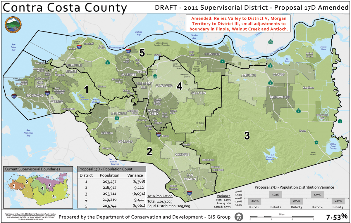
The new Contra Costa County Board of Supervisors districts

“Not a perfect plan…but the plan that most reflects the commonalities of communities” – Supervisor John Gioia

By Allen Payton, Publisher

Most of Antioch will have a new County Supervisor starting in September, while the northern part of the city will continue to be represented by Supervisor Federal Glover in District 5.

On Tuesday, July 26, the Contra Costa Board of Supervisors on a 3-2 vote, approved a final redistricting plan for their five districts which splits Antioch along Highway 4 and East 18th Street, with most of the city in an East County district with Oakley, Brentwood, Discovery Bay, Bethel Island, Byron and Knightsen.

The larger part of Antioch south of Highway 4 and East 18th Street will move into District 3, currently represented by Supervisor Mary Nejedly Piepho of Discovery Bay, as of September 8, which is 30 days after the August 9 scheduled final vote on the new plan.

Supervisors John Gioia, Karen Mitchoff and Glover voted for the new plan, while Supervisors Gayle Uilkema and Piepho voted against it. The latter two preferred a plan that did the least to change the current district configuration.

The new map was a variation of the plan proposed and submitted by the Contra Costa Citizens Redistricting Task Force (of which I was the Chairman), which was labeled Concept 6 and garnered the most support during the public process, including 14 workshops throughout the county, emails, postcards and letters.

However, in that plan only Concord – the county’s largest city – was split and it had the smallest population difference from one district to the next at 3.56%.  That was opposed by Mitchoff of Pleasant Hill who currently represents Concord and made keeping that city whole one of the key requirements for her vote.

So, in order to obtain her support, Gioia made changes to Concept 6 and it was relabeled Proposal 17, splitting Antioch, Pinole, Walnut Creek and Concord by 10,000 to 11,000 residents each and presented it at the July 12 Board meeting.

But, Mitchoff still opposed that. So Glover, who was prepared for such a possibility, presented Proposal 17D at the same meeting, which made Concord whole, but split Antioch further and the San Ramon Valley, moving Diablo, Blackhawk and Camino Tassajara into the East County district.

Further changes were made to that plan to bring it under an 8% population deviation between districts and labeled Proposal 17D Amended, and presented at the July 26 meeting.

Uilkema, who is up for reelection next year and will now have half her district new, with the San Ramon Valley in and Hercules, Rodeo, Crockett and Martinez out of the district, argued for making the least amount of change.

“The law says it is a mandate for adjustment,” she stated. “I will be supporting map 15.”

Gioia, the main member pushing for what Uilkema labeled “radical change”, spoke of the current districts in support of the new plan.

“We’re correcting an error that occurred 10 years ago,” he said. “With the goal of keeping as many cities whole. While 17D Amended is not a perfect plan, it is the plan the most reflects the commonalities of communities.”

Before the vote, things got heated between Mitchoff and Piepho.

“We’re not making a major change, here,” Mitchoff stated. Piepho rolled her eyes and tilted her head back and looked at the ceiling in response. “If we ever thought we were going to get a perfect map, we should be recalled.”

Piepho who lost part of Walnut Creek and the entire San Ramon Valley from her district, gave an empassioned speech in favor of her Proposal 15, which kept whole all the cities and communities in the county, and had the lowest population deviation of the final five plans under consideration by the Board, that day.

“How can you split Antioch, Pinole, Walnut Creek and the San Ramon Valley and meet your definition of keeping the commonalities of communities (quoting Gioia’s earlier comments)?” she asked of her fellow Board members.

One last effort by the task force was made at that meeting, by presenting a plan labeled 17E, which revised Proposal 17, making Antioch and Pinole whole, keeping Walnut Creek split by leaving only Rossmoor in District 2 and splitting Concord by about 5,000 less than in Concept 6. A variety of individuals spoke in favor of the proposed plan, including Antioch Councilwoman Mary Rocha and East County Democrats for Action President George Van Hasselt.

Rocha also argued from the standpoint of which plan had the highest percentage of Latinos in each district. Both Proposal 17D Amended and 17E have three districts that are close to or more than 30% Hispanic.

But, none of the Supervisors would bring up17E for consideration and in the end it was Proposal 17D Amended which was adopted.

“This was the compromise,” Glover said following the meeting. “I felt it gave everyone a little bit of what they wanted. The magic here was getting to three. It keeps me representing part of Antioch, dealing with issues of power plants and the annexation.”

“It was a good process,” he added. “One of the best in terms of public engagement. The plan reflects that input.”

Glover gave up Oakley, Bethel Island and most of Antioch, and picked up Clyde, Martinez, Pacheco, Port Costa, Crockett, Rodeo, Hercules and part of Pinole in his new district.

Piepho offered her thoughts following the meeting.

“I already represent Antioch,” she said. “It will now be more direct in the future.”

“I look forward to continue working on delta water issues, transportation issues of Highway 4, the Bypass and Vasco Road.”

Both Glover’s and Piepho’s terms end and they will be up for election, next year.

For more information on the new map, with detailed population and demographic information, vi sit www.ccredistricting.org and click on Maps and Data.


Interpretive Signs for Prewett Burrowing Owl Preserve

Tuesday, July 26th, 2011

Burrowing Owl Conservation Network has been awarded a grant for the manufacture of four interpretive signs to be installed at the 24-acre Prewett Family Park Burrowing Owl Habitat Preserve in Antioch.

The Board of Supervisors approved the Fish and Wildlife Committee’s recommendation for dispersal of grant funds from the Contra Costa County Fish and Wildlife Propagation Fund, which is entirely supported by fine revenues resulting from violations of Fish and Game Code.

This newly created wildlife and habitat preserve has a number of designated pedestrian access trails that allow and encourage visitors to observe from a distance burrowing owls, other raptors and wildlife that inhabit this suburban grassland ecosystem year-round.

“As burrowing owls are a California Species of Special Concern and have witnessed steep declines in the San Francisco Bay Area and California, we believe community education and outreach is a vital part of their survival and protection of their habitat. We have found many people are unaware of the existence of burrowing owls, have never seen them in the wild, or are simply unaware that Contra Costa County is fortunate to have them as year-round residents,” said Scott Artis, Executive Director of Burrowing Owl Conservation Network.

“As such, these signs will provide species and habitat information and will be used to inform visitors and complement a museum-quality burrowing owl diorama and educational program that we are currently raising much needed funds for.”

The interpretive signs will serve as a means by which the value of protecting, conserving, and preserving wildlife and habitat can be passed on to county residents and visitors. Because burrowing owls rely on fossorial mammals (e.g. ground squirrels) for the construction of their burrows, the four interpretive signs will also highlight the interdependency between species and demonstrate the value of protecting functioning ecosystems.

For more information and to donate, please visit http://burrowingowlconservation.org and indicate that you would like your donation designated to the Prewett Family Park Burrowing Owl Habitat Preserve.

Burrowing Owl Conservation Network is a non-profit charitable organization that advocates for the protection and restoration of the Western Burrowing Owl and promotes the preservation and careful management of habitat to prevent loss, foster healthy populations, and maintain intact natural communities for an ecologically sound future.

Highway 4 to Close Wednesday Night

Thursday, July 21st, 2011

The contractor for the Highway 4 widening project at Loveridge Road will close all lanes on westbound Highway 4 at Loveridge Road for several hours on Wednesday, July 27 between 10 p.m. and 3:30 a.m. This work is to ensure public and crew safety while crews work to place steel piles for the bridge structure at Loveridge Road.

The detour for this work will be as follows: motorists will be directed off the highway at Somersville Road/Auto Center Drive, left on Somersville Road, continue on to Auto Center Drive, left on Tenth Street, left on Loveridge Road, right on California Avenue, and left on westbound Highway 4.

Motorists are advised to expect delays and allow extra time for their commute. Please drive with caution through the detour and leave a safe traveling distance between your vehicle and the vehicle ahead of you. Caltrans and CCTA appreciate your patience as we work to improve the highways. For the most current information on all SR-4 corridor closures please visit http://widensr4.org.

Endangered Delta Smelt Population Improves

Wednesday, July 20th, 2011

Young Delta smelt abundance this year roughly doubled when compared to last year but is a small fraction of their historical abundance, state biologists say. The improvement is likely due in large part to higher than usual flows from the San Joaquin and Sacramento rivers this year which resulted in better habitat conditions and water quality.

Because it is exceptionally difficult to determine the actual number of Delta smelt, Department of Fish and Game (DFG) biologists use survey data to develop “indices” of the species’ abundance. An index is a number that is likely to vary in direct proportion to abundance. For example, if a hypothetical index were to double from 4 to 8 then abundance would also have doubled (e.g., from 200,000 to 400,000).

The 20-Millimeter Survey index of young Delta smelt abundance – which has been developed yearly since 1995 and is named after the approximate size of fish it collects – was 8.0 this year while the index in 2010 was 3.8 and its record high was 39.7 in 1999. The Summer Tow Net Survey index of slightly-older Delta smelt abundance – which has been developed yearly since 1959 and is named after the type of net used to collect fish – was 2.2 this year while the index in 2010 was 0.8 and the record high was 62.5 in 1978.

The increased number of young Delta smelt is encouraging, but because it is still early in their one-year life cycle, the abundance of adults may or may not increase similarly. DFG will continue to monitor the population and at the conclusion of the Fall Midwater Trawl Survey in December will calculate and then release an index of sub-adult Delta smelt abundance.

Delta smelt occur only in the Sacramento-San Joaquin River Delta. The finger-sized fish was historically one of the most abundant in the Delta, but the species declined substantially and was listed as threatened under the California and Federal Endangered Species acts (ESA) in 1993. After a further decline, the species was designated as endangered in 2010 under the California ESA.

Ongoing efforts to protect and recover the population include research on threats to the species, active management to minimize loss at water diversions under federal ESA biological opinions and a state ESA authorization, development of the Bay Delta Conservation Plan, improved water quality, habitat restoration and conservation of genetic diversity through special hatchery-rearing techniques.

To see how the indices of Delta smelt abundance have varied over the years, please visit www.dfg.ca.gov/delta/data/townet/indices.asp?species=3and http://nrm.dfg.ca.gov/FileHandler.ashx?DocumentID=34731.