


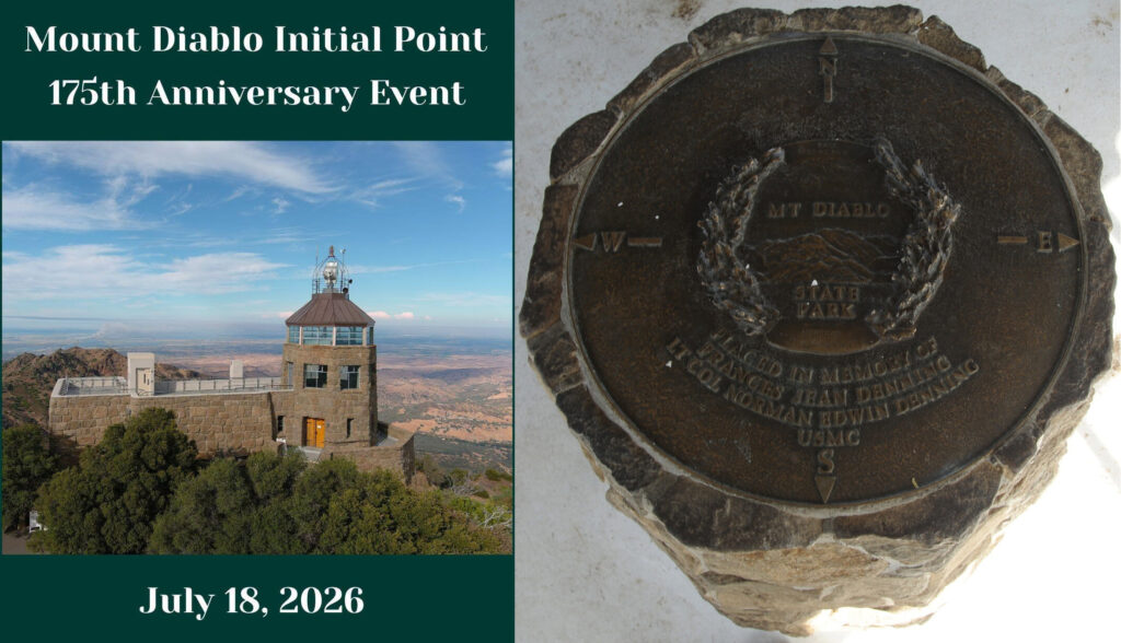
Mount Diablo Initial Point’s 175th Anniversary to celebrate California’s surveying heritage July 18th
Free historic public event commemorates one of the most significant survey monuments in the American West
By Mount Diablo State Park & Public Land Survey System Foundation
Join us on July 18, 2026, for a day-long public celebration commemorating the history and enduring importance of one of the West’s most significant surveying landmarks and an important day in California mapping history.
On a hot summer day in 1851 Colonel Leander Ransom and his survey crew carried their equipment to the top of Mount Diablo and established the Mount Diablo Initial Point – the starting point for mapping property lines for much of California and all of Nevada.
Celebrate the 175th anniversary of the Initial Point with us…explore antique and modern surveying equipment, visit information booths, enjoy hands-on exhibits showcasing the science and practice of land surveying and activities designed to introduce younger visitors to the profession. Land surveyors and historians will be on hand to demonstrate equipment and answer questions about the history and significance of the Initial Point and Mount Diablo’s prominence. Guided tours will point out the original survey monuments housed inside the Summit Visitor Center.
The free educational event will be held from 10:00 a.m. to 4:00 p.m. at the Summit Upper Lot in Mount Diablo State Park. Visitors of all ages are invited to experience interactive exhibits, historical surveying demonstrations, educational presentations, and family-friendly activities that illustrate the vital role surveying has played in the development of California and Nevada.
According to The Center for Land Use Interpretation, the Mount Diablo Initial Point “is one of 37 federal survey points of origin covering the USA (outside of the 13 original colonies), known as Initial Points, selected over the course of 150 years, to anchor newly acquired federal land to the legal and cartographic grid.
“Most Initial Points are created incidentally, as baselines (and sometimes the meridians) are usually created first, with one end anchored on relatively immutable geographic features, such as the confluence of rivers, or latitudinal lines. The west has a number of exceptions, where prominent peaks were selected to be Initial Points, and then base-lines and meridians were drawn from them, as their visibility from great distances aided the surveyor’s task. Such was the case with Mount Diablo, an isolated mound rising above the surrounding valley, east of the San Francisco Bay area.”
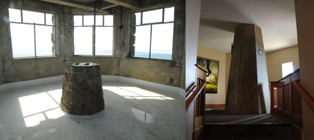
“Mount Diablo has the most elaborate commemorative architectures of all the Initial Points. The building at the top of the mountain, built by the Civilian Conservation Corps in the 1930s, contains a small museum and encloses a monument built on top of the summit. The building itself extends the peak another 45 feet in elevation. A concrete column, built at the same time as the rest of the structure, sits atop the exposed bedrock of the summit and continues through the ceiling to a viewing gallery on the level above where it is topped with a brass plate. The rock of the actual summit is exposed at the base of the concrete column. An opening at the base of the column was provided to allow access to the exact spot from which the survey was conducted, marked now by a copper bolt head left from a 1876 triangulation station.”
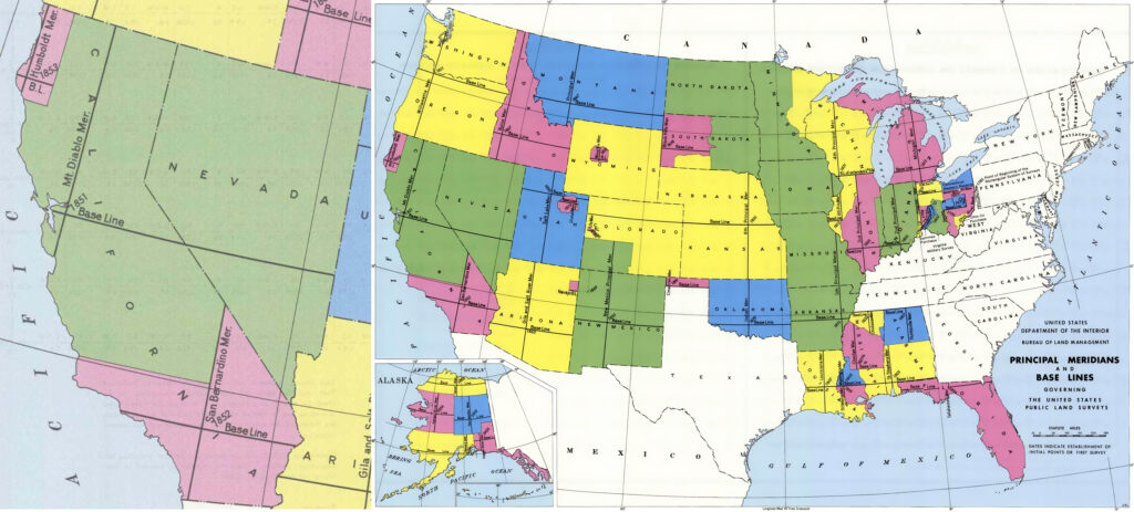
According to the Mount Diablo Surveyors Historical Society, “California has three initial points; Mount Diablo Base and Meridian (est. 1851) (center), San Bernardino Base and Meridian (est. 1852) (bottom), and Humboldt Base and Meridian (est. 1853) (top). Initial points are the starting points, and were established to describe and enable the government to sell public lands covering California and Nevada which were part of the Public Lands Survey System (PLSS).”
Visitors are encouraged to bring lunch, snacks, drinks and sunscreen and plan to spend the day enjoying the mountaintop setting while learning about one of California’s most enduring historical landmarks.
California State Parks, the Mount Diablo Surveyors Historical Society and Mount Diablo Interpretive Association are presenting this event and invite visitors to drop in between 10am-4pm at the Summit Visitor Center parking lot. Parking in this lot will be very limited. Please follow signs to park in the lower parking lot. There is a $10 per vehicle park entry fee, but no charge for the event.
For more information about the Public Land Survey System Foundation visit www.plssfoundation.org.
Click for more information about Mount Diablo State Park or www.facebook.com/MountDiabloStatePark#.
Allen D. Payton contributed to this report.
the attachments to this post:

Mt Diablo CA & US Meridians & Base Lines map

Mt Diablo Initial Point marker column

Mt Diablo Initial Point 175th 071826