


PG&E power shut-offs “likely” in Contra Costa Oct. 17-19
By Allen D. Payton
According to Con Fire, “A Public Safety Power Shutoff (PSPS) may be possible in parts of Contra Costa County from 10/17 to 10/19 to help prevent wildfires. For details and resources on how to prepare visit PG&E Outage Center – PSPS 7-Day Forecast (pge.com)
PG&E provided the following details:
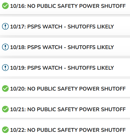
10/17: PSPS Watch – Shutoffs likely
Affected Areas:
- Some parts of the following counties may be affected
- Specific addresses, maps, and shutoff details are typically available 2 days before shutoff.
Counties under Watch: Due to high winds and dry conditions, a shutoff is likely
- Alameda
- Colusa
- Contra Costa
- Glenn
- Lake
- Mendocino
- Napa
- Santa Clara
- Shasta
- Solano
- Sonoma
- Tehama
- Yolo
Get notifications for your address
Forecast
This forecast is based on weather conditions and fuel moisture content only. It does not include other criteria used to determine whether a PSPS may be necessary. This forecast only provides a broad overview for a potential PSPS event in the next 7 days. It is determined from an analysis of forecast weather, the potential for wind-related damage, and fuel moisture content in dead and live vegetation. It is not a fire danger forecast. The forecast is broken down by county. PSPS decisions are made at more granular levels. Only a portion of a county may experience a PSPS event. While a PSPS event may not be expected for an area, due to the interconnectivity of the grid any location within PG&E territory may be subject to PSPS event.
PG&E 7 Day Public Safety Power Shutoff (PSPS) and Enhanced Powerline Safety Settings (EPSS) Potential: Wednesday October 16, 2024 Evening Update: The forecast remains on track for a weather system to enter the Great Basin resulting in breezy to locally gusty offshore winds tomorrow through Saturday afternoon. The PSPS 7-day forecast continues to highlight Watch status for counties that are expected to experience potential PSPS weather conditions tomorrow through Saturday. Note that entire counties will not be deenergized and this forecast is only intended to show counties that have a non-zero customer impact from a potential PSPS event. The exact areas in scope for PSPS will be available at the public outage map here, https://pgealerts.alerts.pge.com/outage-tools/outage-map/, by selecting future PSPS outages.
Previous Discussion: A weather system is beginning to push into Northern California this morning and is bringing showers to portions of the North Coast, with those showers expected to continue to develop across portions of northern California through this afternoon, mainly across the Southern Cascades and northern Sierra Nevada. Behind today’s system, dry northerly winds will develop along the western side of the Sacramento Valley tomorrow before more widespread offshore flow develops tomorrow night through midday Saturday. The strongest winds are expected in the Sierra Nevada foothills, the western Sacramento Valley, elevated Bay Area terrain and elevated terrain in portions of the Central Coast.
Winds will decrease in strength but remain offshore through Sunday, before more settled weather returns early next week. Multiple Red Flag Warnings go into effect tomorrow night across the territory as well as High Risk indications from other federal agencies. The PSPS 7 day forecast is in Watch status for counties that are expected to experience potential PSPS weather conditions Thursday through Saturday. Note that entire counties will not be deenergized and this forecast is only intended to show counties that have a non-zero customer impact from a potential PSPS event. The exact areas in scope for PSPS will be available at the public outage map here, https://pgealerts.alerts.pge.com/outage-tools/outage-map/, by selecting future PSPS outages.
Fuels: An abundant and fully cured grass crop is present at all elevations. Dead fuel moisture values are expected to remain very low due to recent hot temperatures. Live fuel moisture values have largely fallen to below normal levels over the course of this hot summer and are below critical values and near seasonal minimums.
The latest 4 Month Seasonal Outlook from Northern Operations Predictive Services is forecasting normal to above normal fire activity in October and normal fire activity November through January. Southern Operations Predictive Services is forecasting normal to above normal significant fire potential across the territory October through December and normal fire activity for January. There are 646 of 788 circuits in High Fire Risk Areas (HFRA) that are EPSS-enabled today, with 48 of these circuits having at least one EPSS Buffer device enabled. The remaining 142 circuits in HFRA will have devices postured in normal settings due to seasonable temperatures.
Additionally, zero EPSS Buffer-only circuits are enabled today. Please note: This forecast is published daily by an operational meteorologist from PG&E’s Meteorology and Analytics team. This forecast has been customized for PG&E utility operations and should not be used for any other purpose or by any other entity.
This forecast only provides a broad overview for a potential Public Safety Power Shutoff (PSPS) event in the next 7 days as determined from an analysis of forecasted weather, the potential for wind-related damage, and fuel moisture content in dead and live vegetation. It is not a fire danger forecast. The forecast is broken down by county; however, PSPS decisions are made at more granular levels; thus, only a portion of a county may experience a PSPS event.
While a PSPS event may not be expected for an area, due to the interconnectivity of the grid any location within PG&E territory may be subject to PSPS event. Daily PG&E operational decisions should be based on the PG&E Utility Fire Potential Index (FPI), which presents detailed FPI rating forecasts from R1 to R5-Plus for each FPI Rating Area in the PG&E territory today (Day 0) through Day 2. To subscribe to the PG&E Utility FPI, click here
PLEASE NOTE: This forecast is published daily by an operational meteorologist from PG&E’s Meteorology and Analytics team. This forecast has been customized for PG&E utility operations. It should not be used for any other purpose or by any other entity.
the attachments to this post:
PG&E PSPS 7-Day Forecast

PG&E PSPS 7-Day Forecast 10-16 thru 10-22-24