By Allen Payton
On Thursday February 8, 2018 a coalition of Antioch residents and community groups, entitled the Antioch Community to Save Sand Creek, submitted the text of the “Let Antioch Voters Decide: The Sand Creek Area Protection Initiative” to the City of Antioch. According to a press release from the group, the initiative is in response to plans for the remaining 2,800 houses in the Sand Creek area at Antioch’s southern border, the undeveloped area stretching from Deer Valley Road west to Black Diamond Mines Regional Park. The initiative would give Antioch voters the right to vote on Sand Creek Area projects or changes to Antioch’s Urban Limit Line.” 180208 Initiative
However, the voters of Antioch already voted to allow development in the Sand Creek area both in 1990 with the passage of the countywide Measure C, as well as with the passage of Antioch’s Measure K in 2005. Measure C established the countywide Urban Limit Line and Measure K moved the line back out and established a city Urban Limit Line (ULL), which supersedes the county’s line, after the Board of Supervisors moved the line in and cut the former Roddy Ranch golf course and planned development of 640 homes in a gated community, out of the line. Those 900 acres have since been sold by Roddy and his partners to the East Bay Regional Parks District and are now publicly owned open space inside the ULL.
The initiative petition was signed by three Antioch residents, Michael Amorosa, Selina Button and Kristina Gutilla. However, the effort is also backed by Save Mt. Diablo, Greenbelt Alliance, Sierra Club San Francisco Bay, the California Native Plant Society and Antioch Creeks & Trails Alliance.
Organizers say the “Let Antioch Voters Decide: The Sand Creek Area Protection Initiative” would: Require a vote to allow any major development in the initiative area; limit the extent and amount of development in a 3 square mile (1800-acre) area between Deer Valley Road and Black Diamond Mines Regional Preserve; protect the existing Urban Limit Line; preserve nature, open spaces, and historic qualities; maintain agriculture; protect the Sand Creek stream corridor; limit traffic in Antioch; decrease impacts on schools, water police fire and other services; help focus city investments, revitalization and economic development on existing neighborhoods, downtown and along the waterfront.
It would do so by designating the roughly 1,800-acre area between Kaiser Hospital and Black Diamond Mines for rural residential, agricultural and open space uses. It would require a vote of Antioch voters to allow more intensive development.
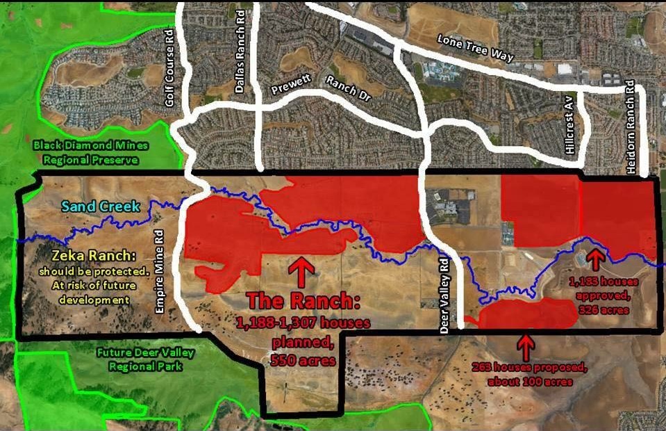
The effort is specifically targeting the project known as The Ranch where as many as 1,307 homes are proposed, down from 1,700 just two years ago, as well as Zeka Ranch project, on the former Higgins Ranch property, at the western end of the valley. That property is immediately adjacent to the Black Diamond Mines Regional Preserve land, publicly owned by the East Bay Regional Parks District. – https://www.theranchantioch.com/
One project left off of the list that has yet to be approved, is the proposed development known as the Olive Groves, which includes 300 homes in a gated senior community south of Sand Creek and east of Deer Valley Road.
The initiative, if passed, would also make Antioch’s Urban Limit Line permanent. Under Measure K, through December 31, 2020, only the voters may change the location of the Line. “After that date voter approval is not required and the urban boundary can be changed by the Antioch city council any time they want. Maintaining voter approval of the urban limit line is in the best interests of Antioch residents,” the organizers claim.
 Six Months to Gather Signatures
The City had 15 days from Feb. 8 to provide a title and summary before signature gathering for the initiative could begin. According to Antioch City Clerk Arne Simonsen, “the Title & Summary was prepared by the City Attorney which I received on February 23rd and immediately sent to the proponent(s) of the initiative.” Initiative Title & Summary
However, Simonsen said it is too late to get the initiative on the June ballot and the soonest it can make it would be the ballot in November.
“They have 180 days from the date they publish their Notice of Intent to Circulate Petition in the newspaper to gather the necessary signatures,” he said. That occurred on Feb. 28. The group then must print the initiative petitions and gather the necessary signatures to qualify the measure. Published Notice of Intent 2-28-18
The group has to obtain 10% of the registered voters in the city as of the last time the County Registrar of Voters updated the California Secretary of State. That occurred early last year, according to both Simonsen and County Clerk-Registrar of Voters, Joe Canciamilla.
There were 51,040 registered voters in Antioch at that time. So, the group has to gather 5,104 valid signatures of registered Antioch voters. That will give them until sometime in late August to gather and submit the required signatures. The cut-off date to make it onto the November ballot is mid-August.
If the group is unable to make the November ballot, the soonest the initiative could be up for a vote would be in June 2020 because, according to Simonsen, “the initiative did not call for a special election, so it would have to appear on a regular election.”
Also, if the council approves the remainder of the homes prior to the November election the initiative will be moot, except for making the ULL permanent. The council could also opt to place the measure on the ballot, even if the group is unsuccessful in obtaining the required signatures or misses the deadline.
“I became involved with the ‘Let Antioch Voters Decide: The Sand Creek Area Protection Initiative’ not only to help conserve and protect open spaces in Antioch, but also to reduce an uptick in unneeded and unwanted development and growth. Antioch, and especially Highway 4, does not have the infrastructure to support an additional 4,000 or more houses,” said Button, an Antioch Rivertown resident who is a member of the steering committee of the “Antioch Community to Save Sand Creek” coalition. “There is so much beauty in Antioch, from the San Joaquin River to Mt. Diablo views, and we have a responsibility to ensure that this natural beauty is preserved for future generations.”
Lack of Infrastructure Capacity Claims Disputed
In response to a question about the capacity built into the design for the Highway 4 widening, Linsey Willis of the Contra Costa Transportation Authority refuted Button’s claims, stating, “The traffic studies completed as part of the required environmental reviews for the expansion of Highway 4 were based upon the housing forecast information released by the Association of Bay Area Governments (ABAG) and the Metropolitan Transportation Commission (MTC) during the late 1990’s. The horizon year of the forecast at that time was 2025.”
In addition, Mike McGill of MMS Design, the engineer of record who designed the roads, water and sewer systems in southeast Antioch said that they were overbuilt. That was to allow for additional capacity to support the projected homes in the Sand Creek Focus Area (formerly referred to as Future Urban Area 1 or FUA-1), as well as the employment area planned for the Laurel Road area north of Highway 4 (known then as Future Urban Area 2 or FUA-2), back in the 1980’s.
“When we set up southeast Antioch, FUA-1 and FUA-2, we were doing that against the backdrop of what we were thinking the ultimate land-use would be. We put together the infrastructure for 12,000 homes in FUA-2,” he said.
“We didn’t do anything for Hwy 4, initially because we had approached Cal-Trans. They said ‘that’s a state highway, we’ll take care of that. You just bring everyone to us,’” McGill explained. “I believe they used the ultimate build-out of Antioch, Oakley and Brentwood. City staff would have given Cal-Trans that data. But, it was much more than 4,000.”
“The local network was designed to handle 12,000 units in FUA-1, now known as Sand Creek Focus Area, and Roddy,” he reiterated. “When the roads are first built, people get used to driving on them almost empty at level of service A. At ultimate build out it’s designed to be at level of service C. Lone Tree Way was designed to be three lanes in each direction without a bike lane, because the bicycles were supposed to be on the Mokelumne trail. But the bicycle coalition didn’t like that because they wanted to be on the street.”
“We had to consider the traffic coming into the area and did the traffic design for FUA-1 and FUA-2 and tied it all together,” McGill continued. “The road network was sized on the ultimate usage. But it all hasn’t been built, yet. There are pieces that aren’t done. When Sand Creek Road connects to Dallas Ranch Road the traffic on Deer Valley Road and Lone Tree Way east of Dallas Ranch Road will reduce significantly. Also, Deer Valley Road will ultimately be expanded all the way to Balfour Road.”
“With Lone Tree valley development reduced, and Roddy now gone, there will be excess capacity in the roadway than everyone originally thought and planned,” he added.
Organizations supporting the initiative.
Additional Reasons for the Initiative
Other organizers shared their concerns with the development, as well.
“For so long it has felt like Antioch has been led blindly by our city council,” said Kristina Gutilla, one of the Antioch residents who submitted the petition to the city. “This gives residents a chance to let their voices be heard, giving control back to the people.”
“Much of Antioch’s creeks, marshes, and landscapes have been paved over,” said Antioch resident Michael Amorosa, who helped create the coalition. “The extremely unique Sand Creek Area, which I like to refer to as the Upper Lone Tree Valley, is high in biodiversity and is an aesthetically alluring watershed with century old riparian forests that absolutely should not vanish in any way, shape, or form. This extraordinary slice of virgin land needs to remain as open space, not bulldozed over.”
“Antioch has a General Plan to guide development in Sand Creek. The amount of development proposed – 4,000 units – is crazy to begin with but the city has ignored the General Plan every time a project has been proposed,” said Seth Adams, Land Conservation Director for Save Mount Diablo. “If they continue at the same rate, we’re talking 4,000 to 8,000 more houses on the south edge of the city.”
However, what Adams didn’t mention is that the City’s original plans for the Sand Creek area was for 8,950 homes, plus the 640 homes at the Roddy Ranch development. Plus, the council in 2016 already approved over 1,200 homes on the eastern end of the area, between Deer Valley Road and the city’s boundary with Brentwood, around Kaiser and Dozier-Libbey Medical High School.
“Conservation of the Sand Creek Area has long been one of our goals,” said Lesley Hunt, California Native Plant Society, East Bay Chapter. “It contains several rare and unusual plants with the potential for more. It is also an important transitional zone between three major ecoregions. Preservation of this area will allow all species to adapt to changing conditions.”
Former Mayor, City Staff Respond
But, the land has been owned by developers since the mid-1990’s and is just now being prepared for development of the new, upscale homes, on larger lots, with gated communities and senior communities.
When reached for comment, former Mayor Don Freitas whose council adopted the new policies Sand Creek Focus Area in 2003 said, “It was a very transparent process. How many meetings did we have with the public? Dozens.”
“We cut the total number of homes by more than 50% from over 8,900 to about 4,000,” he continued. “We wanted the type of housing for Antioch that we don’t currently have.”
Freitas also explained how he said at the time plan had to require that the Antioch Unified School District was “100% satisfied and that there has to be enough money to build the school facilities in FUA1 or I will not support it.”
Antioch’s Community Development Director, Forrest Ebbs further stated the limit of the number of homes for the area.
“What the council did in 2003 was instead of adopting a Specific Plan for the Sand Creek Focus Area, was to adopt policies and include them in the City’s General Plan.” Those policies included the total number of homes “shall not exceed 4,000 and that has been in place since 2003,” he stated.
On the group’s Facebook page, people are encouraged to “get involved by calling Juan Pablo Galvan at Save Mount Diablo” not one of the local organizers. Galvan does not live in Antioch and only Antioch residents who are registered voters can gather signatures for the petitions.
 Initiative’s Leaders Respond to Questions
The following questions were sent to Adams, Amorosa and Button on Tuesday, Feb. 20. Some of the same questions were posted on the group’s Facebook page, without response. However, Adams responded by email that day with, “Thanks for your questions. Our coalition will respond to your email after our Steering Committee has a chance to discuss it.”
- First, other than making the ULL permanent, why do we need another vote of the people when there have already been two to allow development in the Sand Creek Focus Area, as you point out in the press release – the Measure C countywide vote approving the original Urban Limit Line and Measure K, a vote of the people of Antioch which established the city’s Urban Limit Line in the same place?
- Second, what city do you live in and the other leaders and most of the members of your and the other organizations helping lead this effort? Are there upscale, executive homes there in which business owners and executives live who have their businesses close by employing other residents in your cities? Why can’t Antioch have the same thing?
- Did you try to stop that same type of housing in Brentwood, Oakley and Brentwood? Why should Antioch home owners have to move out of our city in order to live in a nicer home on a larger lot with views, or in a gated community, or in a senior community – as some of housing in The Ranch project is proposed? Why can’t Antioch have those same types of homes that other cities in Lamorinda, the San Ramon Valley and Central County have?
- Isn’t it rather elitist and an effort to keep your property values high at the expense of those in our city, preventing us from having a complete mix of housing, now that it’s our turn to have it and we have the Highway widened, the Bypass/Hwy 4 extension will be completed, and the Antioch and Pittsburg BART Stations opened in May?
- Also, by cutting off the additional supply of housing in our county, aren’t you contributing to the increasing home prices and rental prices, and thus to the increase in the homelessness crisis?
- Isn’t it also contributing to actually causing people to buy homes further out in the prime agricultural land of the Central Valley and driving further to their jobs, thus blowing more smoke out of their tailpipes and polluting the environment more?
- Isn’t 65% of the land in the county enough for open space? Plus, 900 acres of the former Roddy Ranch golf course and development have recently and in the past few years become permanent open space with the sale to the East Bay Regional Parks District, as well as acreage donated by Gordon Gravelle off of James Donlon Blvd. where he had upscale homes on view lots planned, all of which is inside the Urban Limit Line.
- Were you aware that originally there were 8,950 homes planned for the Sand Creek Focus Area plus the 640 homes at Roddy and now it’s down to just 4,000 of which 1,200+/- have already been approved?
- Aren’t those enough victories for you and the environmental organizations? A 58% decrease in the total number of homes?
- Finally, it’s been mentioned that the environmental community cut a deal with the development community over Measure C and Measure J, as well, that basically said you can have the 65% of the land outside the line, but that you would leave the land inside the line alone. Is that true?
The three responded on Friday, March 2 with the following:
Frequently Asked Questions (FAQ)
What is the Sand Creek Focus Area?
It’s a 2,783 acre area along the south edge of the city, stretching from Black Diamond Mines east to Brentwood. It’s divided into three parts by Empire Mine Road and Deer Valley Road.
What Land Is Affected by the “Let Antioch Voters Decide Initiative”?
Our initiative would affect about 1850 acres from Deer Valley Road west, past Empire Mine Road, to Black Diamond Mines Regional Park. 80-90% of that area is owned by out of town speculators and developers. Our initiative doesn’t affect the 900 acres east of Deer Valley Road including Kaiser and several already approved developments (Aviano and Promenade).
Why Is Our Coalition Proposing the Initiative?
Antioch residents are fed up. They want change from business as usual. Current development approvals have created many problems that need to be addressed. Additional development to the south will stretch services and damage sensitive, beautiful areas. Our initiative would require that developers persuade Antioch voters that their project benefits Antioch.
What Does The “Let Antioch Voters Decide Initiative” Do?
– Designates 1800 acres west of Deer Valley Road as the Initiative Area and zones it Rural Residential, Agricultural and Open Space.
– Limits development in the Sand Creek area between Kaiser Hospital and Black Diamond Mines, where the city is proposing 4000-8000 houses.
– Require Antioch voter approval to allow more intensive development. It Lets Antioch Voters Decide if they want to allow bigger developments.
– Permanently Require Voter Approval Of Amendments To The Urban Limit Line. The current Antioch Urban Limit Line is only voter approved until December 2020. Our measure would continue to require voter approval for changes.
How Many Signatures Do We Need To Collect?
10% of registered voters in Antioch, or 5100. But some won’t be good signatures, so our goal is 7700 signatures. We’re starting collecting March 3-4. To qualify an initiative you have 6 months but we hope to finish sooner.
How Can I Help?
– We need help collecting signatures to qualify our initiative. It’s easy, we’ll put you with a partner or you can bring your own, and a shift is just two hours.
– Check our Coalition Facebook page: “Antioch Community to Save Sand Creek” or call or email Juan Pablo Galvan at Save Mount Diablo at 925 947-3535 or JPGalvan@savemountdiablo.org, to sign up. www.facebook.com/antiochsavesandcreekandstoptheranch/
– Like and Share our Facebook page – it’s the easiest way to communicate with you.
– Sign up for our E-Blast – it’s our most detailed information.
What’s Special About The Initiative Area’s 1850 acres
From A Neighbor Perspective: It’s beautiful, and if our initiative is adopted, it doesn’t stretch services, it doesn’t add traffic, etc. From A Resource Perspective: The Initiative Area is beautiful ranch land and open space next to Black Diamond Mines and Deer Valley Regional Parks. It’s crossed by sinuous Sand Creek, which supports a number of endangered species, and is part of a wildlife corridor from Black Diamond Mines to Los Vaqueros Watershed. It’s home to many rare plants and animals, including golden eagles and owls, as well as more common species like bobcats, deer and coyotes. It’s the most sensitive part of the Sand Creek Focus Area with big rock outcroppings, ponds, and springs and an oak savannah with huge old oaks separating the Sand Creek Area from Horse Valley and Deer Valley Regional Park. It’s also a bad place for development with underlying coal mines – two coal mining towns were located in the Focus Area. The real question is whether to impact the public’s investment on these parks, or to buffer the parks.
Do We Need More Housing?
Not For Years. Antioch already has over 2000 housing units in town approved but not built. That’s a huge amount of traffic and impacts on schools, police, fire and other services that are yet to be felt.
What Is An Initiative?
“Initiatives” are one of the reforms from the Progressive Area, like “recall” of corrupt politicians. It allows private citizens to write and enact their own laws. After talking with people for over two years, that’s what we did, with the help of a volunteer, retired law professor.
Do We Need This Initiative Now If Development Might Not Happen For Years
Yes. If the area west of Kaiser isn’t protected by our initiative, it will be broken up and fragmented by current development applications, even if development takes place later. The area east of the hospital has already been fragmented. Developers and some elected officials like to suggest impacts of projects might not happen for years. But they also suggest project benefits will happen immediately. Reality is in the middle. They also ignore that other development already approved, but not yet built (more than 2,000 units in Antioch) is still to be felt in our schools and services. Approving more development when thousands of units are already approved Is asking for problems and digging those holes deeper.
What Are “Development Agreements” ?
Developers ask the city for “Development Agreements” which guarantee their rights for extended periods. In many places, those “Development Agreements” rights are negotiated in exchange for substantial public benefit. In East County they’re practically given away.
There Have Been Several Votes On Urban Limit Lines (ULL), Why Do We Need Another?
There have been five major urban limit line decisions affecting Antioch in 30 years. They’re all listed at the bottom of this FAQ. Most of them were very general and don’t affect any of the properties in the Sand Creek area.
Why Didn’t You just Shrink the Urban Limit Line (ULL) to Exclude the Sand Creek Area?
If our initiative qualifies and is approved by the voters, Antioch voters retain control of the area. Developers will have to convince Antioch voters to allow more intensive projects. If we had proposed shrinking the ULL, the city and developers would probably threaten that the area would be developed by the County or Brentwood. Our initiative would maintain local control by Antioch residents.
Who Are We? Are Antioch Residents Involved?
Developers or elected officials sometimes try to suggest that newer residents, nonresidents, or advocacy organizations should be ignored or aren’t legitimate. They never make that claim about out-of-town developers. More than 80% of the area that would be affected by our initiative is owned by 4 out-of-town developer speculators, including two from Southern California and one from Nevada.
We believe anyone who lives, works, or plays in Antioch has a voice. These projects threaten existing neighborhoods and residents’ quality of life. They also threaten two regional parks we’ve all invested in, wildlife and resources, and will have regional impacts on traffic, air quality, etc. Just because you’re a new resident doesn’t mean your voice is less important. The real question is whether new development will stretch services and make problems worse, or better?
The “Antioch Community to Save Sand Creek” coalition which drafted the initiative, is made up of Antioch residents and community groups, and communicates with thousands of Antioch residents. All three of the listed proponents who drafted the initiative—Michael Amorosa, Selina Button, and Kristina Gutilla– are Antioch residents. Community groups such as Save Mount Diablo, Greenbelt Alliance, California Native Plant Society, and Sierra Club all have members who live in Antioch.
How Much Traffic Would The Sand Creek Focus Area Cause?
Each new house generates 10 daily car trips, according to traffic engineers. 4,000-8,000 housing units would generate 40,000 to 80,000 car trips per day, on Empire Mine Road, Dallas Ranch, and Deer Valley Road, through existing neighborhoods to Lone Tree Way, without increasing capacity on any roads. Our initiative does not affect any road extensions, or completion of Sand Creek Road from the Bypass to Deer Valley Road and Kaiser.
How Will Sand Creek Development Affect Our Local Economy?
Since there are already thousands of houses approved to be built in and Around Antioch, this development isn’t needed to create temporary building jobs. The proposed development will compete with existing and already approved but not yet built housing, reducing property and resale values.
Where Are The Developers Going To Get Water?
The developers do not provide any new water supplies, further stretching our water supplies during drought.
Why Didn’t You Include The Area East Of Deer Valley Road In The Initiative?
Our initiative is silent about the area east of Deer Valley Road and wouldn’t change the status quo. Just like it’s silent on other areas. One reason is that area is already fragmented and includes Kaiser and two approved housing projects, Aviano and Promenade. They’re grandfathered in. City officials say they want Senior and Executive Housing. There is a proposed senior project there, the 301-unit “Albers Ranch / the Olive Groves” project (If the city actually makes them perform on promised senior housing.)
Why Did you Exclude the small 4-acre rectangle at the bottom right corner of the initiative area?
There’s only one parcel west of Deer Valley Road mentioned in the city’s General Plan Housing Element. It’s that 4-acre property. None of the other parcels
The City Wants Upscale, Executive, Senior Housing or Business Park, etc.
At about 115,000 people, Antioch is almost tied with Concord for largest city in the County by population. It’s nearly tied for second with Concord in geographic size. It’s a little late to think it’s an underdog. If it doesn’t have what other cities have it’s because the city council is not demanding it, or developers don’t believe the market will support it.
Is This The Place For Executive Housing?
“Executive Housing” is a buzz word meant to suggest “upscale” and is often demanded or promised, but rarely delivered. Executives tend to live close to business parks and headquarters, like Bishop Ranch, Hacienda, and in Silicon Valley or San Francisco. Until the city solves existing problems, businesses are less likely to locate here. Developers claim they will build Executive Housing to get approvals. Then they ask the city to let them build whatever the market will bear at the time of construction. The Antioch City Council usually allows them to change their product whenever they ask. So, one thing gets approved, then what actually gets built is different.
Is This The Place For Senior Housing?
We’re all aging, and many of us have aging parents, so Senior Housing sounds good, but it’s rarely delivered. Cities often suggest they want senior housing because it suggests less commute traffic and no impacts on schools. Then after environmental review is done, they often discard the senior requirement and you get those traffic and school impacts anyway. That’s exactly what’s happening at the Aviano project, east of Kaiser.
Are Our Organizations Working Just In Antioch?
The organizations involved in our coalition have all been working in East County for decades, in a variety of cities, on a variety of projects. Save Mount Diablo for example, began working to create Black Diamond Mines Regional Park in 1973
What Does The Sand Creek Area Have to Do With Mt. Diablo?
The Sand Creek Area is part of the foothills of Mt. Diablo, a wildlife corridor from Black Diamond Mines to Los Vaqueros Watershed, and adjacent to two regional parks Save Mount Diablo helped create, Black Diamond Mines and Deer Valley Regional Park. It’s part of the historic Mt. Diablo Coalfields which began being mined in the 1850s. And the area is part of the Diablo Range, which was defined by the California Geological Survey in the 1850s.
Why is a staff member for Save Mount Diablo, the contact for the effort?
Because this is a big priority for Save Mount Diablo and to make it easy for people asking questions to reach us. Check our Coalition Facebook page: “Antioch Community to Save Sand Creek” or call or email Juan Pablo Galvan at Save Mount Diablo at 925 947-3535 or JPGalvan@savemountdiablo.org, if you have questions. www.facebook.com/antiochsavesandcreekandstoptheranch/
Should We Be Concerned About Our Property Values?
Of course Antioch residents should be concerned about our property values. For many families, it’s our major investment. During the recession, many Antioch houses lost half their values. Every new house that’s built competes with existing houses for resales. Caring about property values and quality of life is common sense.
Does Requiring Developers to “Let Antioch Voters Decide” Restrict Housing Supply?
No. It Requires Developers to Propose Projects Good Enough to Get Voter Support. There are thousands of homes approved but not yet built in East County, including more than 2,000 in Antioch. Every City is required to meet regional housing needs by zoning adequate land for housing. Antioch has zoned and approved more than required. Not a single parcel in our initiative area is required to meet Antioch’s designated housing needs.
If They Don’t Build It Here, Won’t They Build it On Prime Farmland Further Out?
California has had massive waves of development since the Gold Rush. As long as there’s good weather and a strong economy, it will continue. Antioch has more than met its share of regional housing. Residents have the right to preserve their community’s quality of life. Whether we make better development choices now or after there is no more vacant land in Antioch, we face the same choice—smarter growth with fewer impacts. Plenty of communities are building lots of housing without spreading out further.
How Did You Calculate 4,000-8,000 House Number In The Sand Creek Focus Area ?
The City’s General Plan suggests 4000 units in the Sand Creek Area, but for each project so far they’ve amended the General Plan to allowed more. The Sand Creek Focus Area includes 2,783 acres. The approved Aviano and Promenade projects include 1,183 houses on 281 acres east of Kaiser. “The Ranch” proposes 1307 on 552 acres. “Olive Grove” proposes 301 units on 97 acres. In total that’s 2,791 units on 930 acres, just a third of the total acreage. If the city continues ignoring the General Plan at the same pace, that equals 8,352 units on 2,783 acres. So we use a range of 4000 units suggested in the General Plan and 8000, suggested by what’s actually taking place.
What Planning Has Happened In The Sand Creek Area?
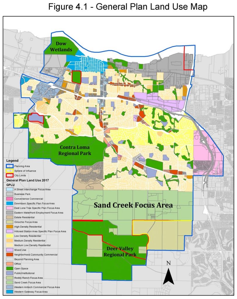
Antioch started but never finished a Specific Plan in the Sand Creek Focus Area (2002-2003) and started but never completed a General Plan Amendment of the 2003 General Plan. The only real land use map is a 2018 photocopy of a 2003 photocopy (below), with a couple of changes on the east end. That’s the level of planning for this area.
Both the 2003 and the 2018 Antioch General Plans say: “Prior to or concurrent with approvals of any development applications other than major employment-generating uses (including, but not limited to a medical facility on the Kaiser property), a specific plan or alternative planning process as determined by the City Council, shall be prepared and approved for the Sand Creek Focus Area.”
The City has never completed a Sand Creek Specific Plan. Instead, a developer proposes a project and the city ignores its vague General Plan Focus Area map, and approves something completely different.
The Sand Creek area was originally called Future Urban Area #1 (FUA#1) and was added to the city in the early 1990s. Around 2002 the city began planning a specific plan for FUA#1. They did inadequate environmental review and when challenged by environmental groups, they tabled the specific plan and never completed it. The only direction about the Sand Creek Focus Area is a few pages in the General Plan, (GP 2003, pg 4-38 to 4-45) and a version of the vague map above, (http://www.ci.antioch.ca.us/CityGov/CommDev/PlanningDivision/docs/Antioch_Adopted_General_Plan.pdf).
In 2003 the City updated the General Plan and included a document that had been developed for the FUA#1 Specific Plan that was never finished, called “Appendix A: Sand Creek Resource Management Plan.” In 2015-2018 the city started to create something like a Specific Plan (a General Plan Amendment) again for the Sand Creek Focus Area as part of a General Plan Update.
Once again they did inadequate environmental review and when challenged by environmental groups, they tabled the plan again and never incorporated it into the General Plan. Bottom Line, the City has started to create a Specific Plan for the Sand Creek Area twice, and never completed either Plan.
Does The Current Specific Plan Or General Plan Protect The Creek?
No. There is no Specific Plan for the area. The General Plan has some vague language but no specific setbacks from the creek. A Management Plan attached to the General Plan refers to the draft Specific Plan that was never completed and a 250’ creek corridor. And for all 3 projects so far, the city has changed the General Plan substantially. Save Mount Diablo was successful in getting a significant creek buffer for the Aviano and Promenade projects, but nothing in the General Plan requires it. The “Let Antioch Voters Decide Initiative” requires a 200’ wide corridor on either side of Sand Creek if approved (400’ total).
Editor’s Note: However, according to Ebbs, “The General Plan has language providing appropriate buffers for development adjacent to Sand Creek. There’s no numerical standard. It’s based on a site-specific analysis because the creek varies and the projects vary. So, there’s not a standard, across-the-board set-back. There is a host of other agencies that review this, that have their standards. But, the plan does not say you can build right up to the creek, by right.”
Urban Limit Line Decisions Affecting the Antioch Area
Nov. 1990 – Measure C – County Urban Limit Line (ULL) was approved, creating – it was expansive and designed to allow a large amount of development. Cities weren’t bound by the ULL, which could be changed by a 4/5 vote of the County Board of Supervisors.
Aug. 2000 – County Urban Limit Line Tightened – The County Board of Supervisors approves tightening the County Urban Limit Line. It still only affects the County.
Nov 2004 – Measure J – Requiring Voter-Approved Urban Limit Lines – The Contra Costa Transportation Authority passes Measure J, requiring that the County and all the cities have voter-approved Urban Limit Lines to qualify for transportation funding.
Nov. 2005 – Measure K Roddy Ranch Developer Urban Limit Line – in response to Measure J, Roddy Ranch/developers circulate Measure K, an expansive Urban Limit Line affecting just Antioch – potentially allowing a large amount of development. The campaign is all about limiting growth but in reality Measure K could allow a lot of development. The measure is approved. It will sunset in Dec 2020, after which point voter approval is no longer needed to change it. At that point it can be changed by the Antioch City Council.
Nov. 2006 – Measure L Unified County Urban Limit Line – in response to 2004 Measure J, the county Board of Supervisors places Measure L on the ballot, referencing the 2000 tightened Urban Limit Line, and various changes all around the County. (Editor’s Note: Measure L did not make any changes to the Urban Limit Line in Antioch).
What’s the 65/35 Plan? Was it an agreement with Environmentalists?
No it wasn’t. In 1990 Conservationists proposed the first County Urban Limit Line Measure, Measure F. The County Board of Supervisors and Developers put a competing Initiative on the ballot, Measure C (see above). Measure C beat Measure F and created an expansive County Urban Limit Line called the 65/35 plan. Developers said “Who cares if there’s an Urban Limit Line if you need binoculars to see it?”
Problem was, Measure C didn’t affect cities. If developers couldn’t get what they wanted from a city, they’d go to the county, and vice versa. Measure C could also be changed by a 4/5 vote of the County Board of Supervisors.
Isn’t There 65% Open Space Outside The Urban Limit Line, And 35% Inside the Urban Limit Line?
No. The 65% standard just suggests non-urban density. That can include all kinds of development like all the houses along Marsh Creek Road, the trailer park, the county jail, etc. The 35% standard is urban, but it can also include all kinds of other uses including protected land. There’s protected land inside the line, and developed land outside the line. In Antioch for example, Contra Loma Reservoir, Dow Wetlands and part of Deer Valley Regional Park are all inside the Urban Limit Line and the City Limits, and are protected.
The line became more useful when it was tightened by the County Board of Supervisors in 2000, and even more so in 2004 when Measure J required that both the county and the cities have voter-approved Urban Limit Lines—that put more control in the hands of residents.
More Information
General Plan: A statement of policies, including text, maps and diagrams setting forth objectives, principles, standards, and plan proposals, for the future physical development of a city or county. The official public document or ‘constitution’ adopted by a county, city or other agency as the policy guide for decisions about its future development and redevelopment. A General Plan usually includes, but is not limited to, a land use plan, housing, transportation, etc. General Plans and General Plan Amendments and are subject to environmental review.
General Plan Amendment: An amendment to the General Plan can involve either a change to the policy text of the plan or a change on the General Plan Map which alters the land use designation of a particular parcel of property. General Plan Amendments and are subject to environmental review. The 1300(-home) “The Ranch” project would require a General Plan Amedment.
Specific Plan: A plan addressing land use distribution, open space availability, infrastructure, and infrastructure financing for a portion of the community. Specific plans put the provisions of the local general plan into action. For example, a “Downtown Specific Plan” or the “Sand Creek Specific Plan” covering a smaller part of the city.
Urban Limit Line: The local government enacts an ordinance that defines on a map where growth will occur in the future and where basic services, such as schools, sewers, water facilities, and police and fire protection, can be provided economically. AKA “Urban Growth Boundary (UGB).” Each one is unique. Some are strong. Some are weak.
Adams also responded to the questions directed to him with, “The leaders of community organizations also represented on the Steering Committee are from a variety of places; all of those organizations have members and donors in Antioch. I personally live in Martinez. All of the developers proposing projects in the initiative area are from out of town or out of state.”
“The initiative isn’t about stopping all development, or any specific kind of development – it’s about giving control to Antioch voters,” he added. “Caring about quality of life and property values is common sense.”
The group filed the necessary paperwork with the Antioch City Clerk’s office on Thursday, March 1 in order to begin raising funds to pay for the campaign. Form 410 Initial Antioch Community to Save Sand Creek rcvd 3-1-18


 The Contra Costa Taxpayers Association (“CoCoTax”) is pleased to announce the formation of a new East Contra Costa chapter. To celebrate, CoCoTax East will hold its inaugural public meeting on Wednesday, March 28 with a luncheon meeting at Vic Stewart’s Restaurant at 2270 Balfour Road in Brentwood.


 SALT LAKE CITY (Grassroots Newswire) March 2, 2018 – The following local students have received their degree from Western Governors University (WGU). The university held its 64th commencement ceremony at the Disney Coronado Springs Resort in Orlando on February 10th to celebrate the graduation of about 15,000 graduates from across the country.
 From Congressman Jerry McNerney