Laser-equipped drone helps improve safety, efficiency on Hwy 4 improvement project

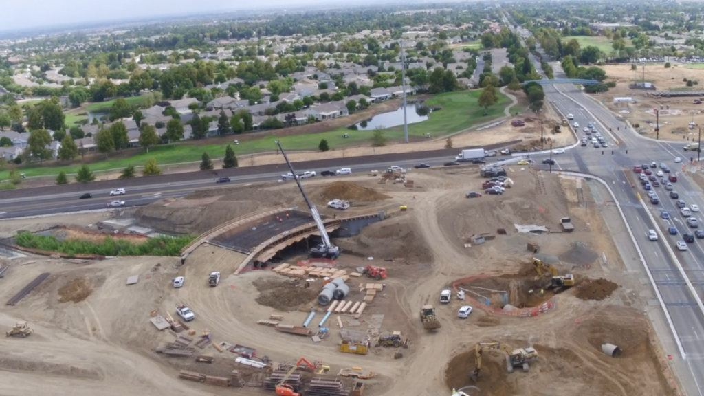
Screenshot from drone video of construction work at the Highway 4 and Balfour Road interchange in Brentwood, Tues., Sept. 12, 2017. Courtesy of Alta Vista Solutions.
Emerging drone technology moves construction and engineering into the future
On Tuesday morning, September 12, 2017, the Contra Costa Transportation Authority (CCTA) and Alta Vista Solutions showcased two emerging technologies on a construction project aimed to improve commutes on Highway 4 in Brentwood (aka the Bypass). Engineers piloted drones equipped with light detection and ranging (LiDAR) lasers–a surveying tool that uses a laser to create high-resolution geographical data.
The combination of the two emerging technologies has never been done in construction before and opens untold possibilities for unmanned aerial vehicle (UAV) technology and related jobs in the future. CCTA featured the system in action by providing a live feed of a drone flight. The feed from this morning’s drone flight can be viewed at altavistasolutions.com/media – bar .
With assistance from engineering firm Alta Vista Solutions (Alta Vista), who proposed the new method, CCTA is flying the LiDAR scanners to measure the volumes of earth that need to be moved during this $74-million project to rework the Balfour Road interchange. The drones ensure that the cut-and-fill earthwork goes efficiently. With LiDAR’s pinpoint accuracy, CCTA can now make needed calculations and monitor site conditions faster, eliminating the unavoidable guesswork involved in manual surveys. Putting LiDAR on drones gathers 15 gigabytes of precise, high-quality data per month, cutting down drastically on time spent surveying. The drones also improve safety by taking workers out of live traffic.
Drone capabilities enable CCTA to track construction progress firsthand as work on Highway 4 continues.
“We are always looking for new ways to increase safety and efficiency on construction projects,” said CCTA Executive Director Randy Iwasaki. “Drones give us aerial views of the site that were hard to come by before, making it safer for surveyors to do their job and helping us manage the large volumes of dirt that are being used to improve this intersection. This technology also allows us to monitor environmentally sensitive areas without disturbing the habitat.”
“This will change engineering and surveying,” said Ed Greutert, principal engineer at Alta Vista Solutions. “Innovations like combining LiDAR and UAVs are opening doors in infrastructure and making us efficient, effective, and safe in ways we couldn’t achieve before.”
Greutert also addresses fears of job loss as automation increases. “Using technology to do the surveying work can lead people to ask if this is the next step to the robot apocalypse – are drones going to take our jobs?” he speculates. “Not quite. It’s going to change jobs. It’s going to create new jobs in technology—and in the Balfour Road case, help people get to work faster.”
CCTA has faced challenges in being the first to test these technologies together.
“This has never been done. LiDAR on a UAV hasn’t worked until now – there are huge possibilities if we can be creative enough to really tap into them,” Greutert noted.
Handling the unprecedented quantity of data generated has also posed a challenge. However, in recent months, the team has succeeded in processing the hundreds of gigabytes collected.
“There are always challenges to pioneering new technology,” Iwasaki said. “But with the benefits this technology can provide in terms of keeping workers safe and managing a complicated construction project, I believe we’ll start to see more widespread use of drones on construction sites within a few years – especially as we discover new applications that can help save time and money. Right now, CCTA is excited to be leading efforts in this new frontier.”
About the Contra Costa Transportation Authority
The Contra Costa Transportation Authority (CCTA) is a public agency formed by Contra Costa voters in 1988 to manage the county’s transportation sales tax program and oversee countywide transportation planning efforts. CCTA is responsible for planning, funding and delivering critical transportation infrastructure projects and programs that connect our communities, foster a strong economy, increase sustainability, and safely and efficiently get people where they need to go. CCTA also serves as the county’s designated Congestion Management Agency, responsible for putting programs in place to keep traffic levels manageable. More information about CCTA is available at ccta.net.
About Alta Vista Solutions
Alta Vista is a California-based engineering firm that has been recognized as the 20th fastest-growing engineering firm in America by Inc. 5000 and was named by Zweig Group as one of America’s Hot Firms. Alta Vista has quickly differentiated itself by performing customized quality management strategies for some of the most complex infrastructure projects in the world. Over the past decade, Alta Vista has worked with public and private organizations to complete large-scale engineering projects that better serve their regions. Known for engineering services that include engineering, inspection, testing, unmanned aerial systems, quality management, and structural health monitoring, Alta Vista has grown and diversified and has been acknowledged in 2017 by ENR Magazine and other media outlets for using innovative solutions and technologies to deliver infrastructure projects faster, better and more cost effectively. For more information about Alta Vista, visit altavistasolutions.com.
the attachments to this post:

Drone video at Hwy 4 & Balfour Rd


