Smartphone App Released by 511
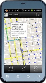
 With just one app, Smartphone users can plan trips on trains, buses and ferries offered by more than 30 public transit agencies. 511, the Bay Area’s traveler information system, is now offering its first smartphone app for transit users. The 511 Transit App is currently available for Android and an iPhone version will be released soon. The free 511 Transit App is a multiple-agency public transit trip planner using GPS-based location tools for smartphones. Ideal for a weekend errand, occasional trip or daily commute, the app serves both residents and visitors who are planning transit trips within the nine-county region.
The new app provides door-to-door transit trip planning and scheduled departure times for transit routes near your location or from a location you specify. It includes information for 720 routes and more than 23,700 transit stops throughout the region. An interactive, dynamic map shows routes and stops along the way, as well as your current position while on the move. Walking directions to and from stops and fares (including transfers) are also displayed.
The 511 Transit App includes data from SF Muni, BART, AC Transit, VTA, SamTrans, Caltrain, Golden Gate Transit, County Connection, Vallejo Transit, LAVTA, Sonoma County Transit, VINE (Napa County) and more than a dozen additional agencies. For a complete list of all transit agencies included in the 511 Transit app, visit the trip planning page.
the attachments to this post:


